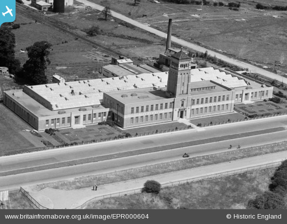
EPR000604 ENGLAND (1935). The Aladdin Building (Lamp Shade Manufactory), Greenford, 1935
© Copyright OpenStreetMap contributors and licensed by the OpenStreetMap Foundation. 2025. Cartography is licensed as CC BY-SA.
Nearby Images (23)
Details
| Title | [EPR000604] The Aladdin Building (Lamp Shade Manufactory), Greenford, 1935 |
| Reference | EPR000604 |
| Date | 9-June-1935 |
| Link | |
| Place name | GREENFORD |
| Parish | |
| District | |
| Country | ENGLAND |
| Easting / Northing | 513754, 183543 |
| Longitude / Latitude | -0.35959198985336, 51.538831604089 |
| National Grid Reference | TQ138835 |
Pins
Be the first to add a comment to this image!
User Comment Contributions
I think that lamp shades were probably more ancillary to the main output of paraffin oil lamps and heaters. |
 The Laird |
Tuesday 7th of February 2017 05:06:18 PM |


![[EPR000604] The Aladdin Building (Lamp Shade Manufactory), Greenford, 1935](http://britainfromabove.org.uk/sites/all/libraries/aerofilms-images/public/100x100/EPR/000/EPR000604.jpg)
![[EPW038798] The Aladdin Building (Lamp Shade Manufactory) and Greenford Trotting Track, Greenford, 1932](http://britainfromabove.org.uk/sites/all/libraries/aerofilms-images/public/100x100/EPW/038/EPW038798.jpg)
![[EPW053618] The Aladdin Building, Greenford, from the south-west, 1937](http://britainfromabove.org.uk/sites/all/libraries/aerofilms-images/public/100x100/EPW/053/EPW053618.jpg)
![[EPW038794] The Aladdin Building (Lamp Shade Manufactory) and Greenford Trotting Track, Greenford, 1932](http://britainfromabove.org.uk/sites/all/libraries/aerofilms-images/public/100x100/EPW/038/EPW038794.jpg)
![[EPW038795] The Aladdin Building (Lamp Shade Manufactory), Greenford, 1932](http://britainfromabove.org.uk/sites/all/libraries/aerofilms-images/public/100x100/EPW/038/EPW038795.jpg)
![[EPW053619] The Aladdin Building, Greenford, from the south-west, 1937](http://britainfromabove.org.uk/sites/all/libraries/aerofilms-images/public/100x100/EPW/053/EPW053619.jpg)
![[EPW038796] The Aladdin Building (Lamp Shade Manufactory), Greenford, 1932](http://britainfromabove.org.uk/sites/all/libraries/aerofilms-images/public/100x100/EPW/038/EPW038796.jpg)
![[EPW053621] The Aladdin Building, Greenford, from the south-west, 1937](http://britainfromabove.org.uk/sites/all/libraries/aerofilms-images/public/100x100/EPW/053/EPW053621.jpg)
![[EPW053622] The Aladdin Building, Greenford, 1937](http://britainfromabove.org.uk/sites/all/libraries/aerofilms-images/public/100x100/EPW/053/EPW053622.jpg)
![[EPW053620] The Aladdin Building, Greenford, from the south-west, 1937](http://britainfromabove.org.uk/sites/all/libraries/aerofilms-images/public/100x100/EPW/053/EPW053620.jpg)
![[EPW038797] The Aladdin Building (Lamp Shade Manufactory), Greenford, 1932](http://britainfromabove.org.uk/sites/all/libraries/aerofilms-images/public/100x100/EPW/038/EPW038797.jpg)
![[EPW038793] The Aladdin Building (Lamp Shade Manufactory), Greenford, 1932](http://britainfromabove.org.uk/sites/all/libraries/aerofilms-images/public/100x100/EPW/038/EPW038793.jpg)
![[EPW053625] The Aladdin Building, Greenford, 1937](http://britainfromabove.org.uk/sites/all/libraries/aerofilms-images/public/100x100/EPW/053/EPW053625.jpg)
![[EPW053623] The Aladdin Building, Greenford, 1937](http://britainfromabove.org.uk/sites/all/libraries/aerofilms-images/public/100x100/EPW/053/EPW053623.jpg)
![[EPW053617] The Aladdin Building, Greenford, 1937](http://britainfromabove.org.uk/sites/all/libraries/aerofilms-images/public/100x100/EPW/053/EPW053617.jpg)
![[EPW053624] The Aladdin Building, Greenford, 1937](http://britainfromabove.org.uk/sites/all/libraries/aerofilms-images/public/100x100/EPW/053/EPW053624.jpg)
![[EPW059347] The Aladdin Building (Lamp Shade Manufactory), Greenford, 1938](http://britainfromabove.org.uk/sites/all/libraries/aerofilms-images/public/100x100/EPW/059/EPW059347.jpg)
![[EPR000029] Western Avenue under construction alongside the Aladdin Building and the Grand Union Canal (Paddington Branch), Greenford, 1934](http://britainfromabove.org.uk/sites/all/libraries/aerofilms-images/public/100x100/EPR/000/EPR000029.jpg)
![[EPR000028] Western Avenue under construction alongside the Aladdin Building and the surrounding area, Greenford, from the north-west, 1934](http://britainfromabove.org.uk/sites/all/libraries/aerofilms-images/public/100x100/EPR/000/EPR000028.jpg)
![[EPW034570] The British Bath Co. Ltd Works, construction of housing on Long Drive and Greenford Trotting Track, Greenford, from the south-west, 1930](http://britainfromabove.org.uk/sites/all/libraries/aerofilms-images/public/100x100/EPW/034/EPW034570.jpg)
![[EPW061233] The Industrial Estate on Western Avenue, Greenford, from the south-east, 1939](http://britainfromabove.org.uk/sites/all/libraries/aerofilms-images/public/100x100/EPW/061/EPW061233.jpg)
![[EPW059346] The Aladdin Building (Lamp Shade Manufactory) and environs, Greenford, 1938](http://britainfromabove.org.uk/sites/all/libraries/aerofilms-images/public/100x100/EPW/059/EPW059346.jpg)
![[EPW034573] The British Bath Co. Ltd Works, construction of the Aladdin Building and the Greenford Trotting Track, Greenford, 1930](http://britainfromabove.org.uk/sites/all/libraries/aerofilms-images/public/100x100/EPW/034/EPW034573.jpg)