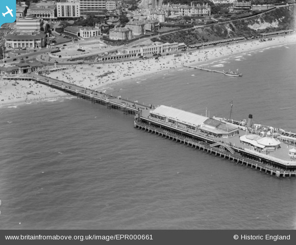
EPR000661 ENGLAND (1935). The pier, Bournemouth, 1935
© Copyright OpenStreetMap contributors and licensed by the OpenStreetMap Foundation. 2025. Cartography is licensed as CC BY-SA.
Nearby Images (25)
Details
| Title | [EPR000661] The pier, Bournemouth, 1935 |
| Reference | EPR000661 |
| Date | 26-June-1935 |
| Link | |
| Place name | BOURNEMOUTH |
| Parish | |
| District | |
| Country | ENGLAND |
| Easting / Northing | 408915, 90556 |
| Longitude / Latitude | -1.8737132904978, 50.713991954705 |
| National Grid Reference | SZ089906 |
Pins
 Louis |
Wednesday 12th of November 2014 07:22:37 PM |
User Comment Contributions
View from the pier, 07/11/2014 |
 Class31 |
Saturday 8th of November 2014 09:30:23 PM |


![[EPR000661] The pier, Bournemouth, 1935](http://britainfromabove.org.uk/sites/all/libraries/aerofilms-images/public/100x100/EPR/000/EPR000661.jpg)
![[EPW013551] The Pier, Bournemouth, 1925](http://britainfromabove.org.uk/sites/all/libraries/aerofilms-images/public/100x100/EPW/013/EPW013551.jpg)
![[EPW000252] The Pier, Bournemouth, 1920](http://britainfromabove.org.uk/sites/all/libraries/aerofilms-images/public/100x100/EPW/000/EPW000252.jpg)
![[EAW050053] Bournemouth Pier and environs, Bournemouth, 1953](http://britainfromabove.org.uk/sites/all/libraries/aerofilms-images/public/100x100/EAW/050/EAW050053.jpg)
![[EPW041047] The pier and the town, Bournemouth, from the south-east, 1933. This image has been produced from a print.](http://britainfromabove.org.uk/sites/all/libraries/aerofilms-images/public/100x100/EPW/041/EPW041047.jpg)
![[EPW000261] Bournemouth Pier, Bournemouth, from the west, 1920](http://britainfromabove.org.uk/sites/all/libraries/aerofilms-images/public/100x100/EPW/000/EPW000261.jpg)
![[EAW049056] Bournemouth Pier and the town, Bournemouth, from the south-east, 1953](http://britainfromabove.org.uk/sites/all/libraries/aerofilms-images/public/100x100/EAW/049/EAW049056.jpg)
![[EPW041046] The pier and the town, Bournemouth, from the south-east, 1933](http://britainfromabove.org.uk/sites/all/libraries/aerofilms-images/public/100x100/EPW/041/EPW041046.jpg)
![[EPW037422] Bournemouth Pier and West Cliff, Bournemouth, 1932](http://britainfromabove.org.uk/sites/all/libraries/aerofilms-images/public/100x100/EPW/037/EPW037422.jpg)
![[EPW000253] The Pier, Bournemouth, 1920](http://britainfromabove.org.uk/sites/all/libraries/aerofilms-images/public/100x100/EPW/000/EPW000253.jpg)
![[EPW037418] Bournemouth Pier, Bournemouth, 1932](http://britainfromabove.org.uk/sites/all/libraries/aerofilms-images/public/100x100/EPW/037/EPW037418.jpg)
![[EPW018164] Pier Approach and the beach by Bournemouth Club, Bournemouth, 1927. This image has been produced from a copy-negative.](http://britainfromabove.org.uk/sites/all/libraries/aerofilms-images/public/100x100/EPW/018/EPW018164.jpg)
![[EPW018167] Pier Approach, Bournemouth, 1927. This image has been produced from a print.](http://britainfromabove.org.uk/sites/all/libraries/aerofilms-images/public/100x100/EPW/018/EPW018167.jpg)
![[EAW034624] Pier Approach, the Pleasure Gardens and the town, Bournemouth, from the south-east, 1951](http://britainfromabove.org.uk/sites/all/libraries/aerofilms-images/public/100x100/EAW/034/EAW034624.jpg)
![[EPW061510] Pier Approach and environs, Bournemouth, from the south-east, 1939. This image has been produced from a damaged negative.](http://britainfromabove.org.uk/sites/all/libraries/aerofilms-images/public/100x100/EPW/061/EPW061510.jpg)
![[EAW018154] The pier, pleasure gardens and the town, Bournemouth, from the south-east, 1948. This image has been produced from a print.](http://britainfromabove.org.uk/sites/all/libraries/aerofilms-images/public/100x100/EAW/018/EAW018154.jpg)
![[EPW013553] Pier Approach, Bournemouth, 1925](http://britainfromabove.org.uk/sites/all/libraries/aerofilms-images/public/100x100/EPW/013/EPW013553.jpg)
![[EAW050052] Bournemouth Pier and the town, Bournemouth, from the south-east, 1953](http://britainfromabove.org.uk/sites/all/libraries/aerofilms-images/public/100x100/EAW/050/EAW050052.jpg)
![[EPW013560] Bournemouth Pier and beach, Bournemouth, 1925. This image has been produced from a print.](http://britainfromabove.org.uk/sites/all/libraries/aerofilms-images/public/100x100/EPW/013/EPW013560.jpg)
![[EPW018155] West Cliff Promenade and the town, Bournemouth, from the south, 1927. This image has been produced from a print.](http://britainfromabove.org.uk/sites/all/libraries/aerofilms-images/public/100x100/EPW/018/EPW018155.jpg)
![[EPW000266] Pier Approach, Bournemouth, 1920](http://britainfromabove.org.uk/sites/all/libraries/aerofilms-images/public/100x100/EPW/000/EPW000266.jpg)
![[EPW013552] Bath Hill and the sea front, Bournemouth, 1925](http://britainfromabove.org.uk/sites/all/libraries/aerofilms-images/public/100x100/EPW/013/EPW013552.jpg)
![[EAW002993] Repair works to Bournemouth Pier, Exeter Road and environs, Bournemouth, from the south-east, 1946](http://britainfromabove.org.uk/sites/all/libraries/aerofilms-images/public/100x100/EAW/002/EAW002993.jpg)
![[EPW041041] The seafront and town, Bournemouth, from the south-east, 1933](http://britainfromabove.org.uk/sites/all/libraries/aerofilms-images/public/100x100/EPW/041/EPW041041.jpg)
![[EAW035603] Undercliff Drive and the pier, Bournemouth, from the east, 1951. This image has been produced from a print.](http://britainfromabove.org.uk/sites/all/libraries/aerofilms-images/public/100x100/EAW/035/EAW035603.jpg)