
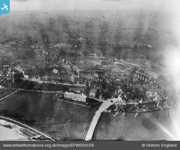
EPW000159 ENGLAND (1920). Market Road and environs, Rye, from the east, 1920
© Copyright OpenStreetMap contributors and licensed by the OpenStreetMap Foundation. 2025. Cartography is licensed as CC BY-SA.
Nearby Images (8)
EPW000159

EPW000127

EPW035354

EPW026240

EPW026243

EPW039358

EPW026236

EPW039360

Details
| Title | [EPW000159] Market Road and environs, Rye, from the east, 1920 |
| Reference | EPW000159 |
| Date | February-1920 |
| Link | |
| Place name | RYE |
| Parish | RYE |
| District | |
| Country | ENGLAND |
| Easting / Northing | 592272, 120608 |
| Longitude / Latitude | 0.73777134824075, 50.952238180075 |
| National Grid Reference | TQ923206 |
Pins
 RJG |
Wednesday 8th of August 2012 10:52:17 PM | |
 somoody |
Friday 13th of July 2012 04:56:25 PM | |
somoody |
Friday 13th of July 2012 04:55:18 PM | |
Martin Taylor |
Friday 29th of June 2012 11:41:32 PM | |
Dear Martin, That’s great; we’ve reviewed your suggestion and thanks to your help we can update the catalogue. The revised record will appear here in due course. Hope you have the same success solving some of our other mysteries! Katy Whitaker Britain from Above Cataloguer |
Katy Whitaker |
Monday 2nd of July 2012 12:24:31 PM |
User Comment Contributions
This view is looking across Rye from the A259 (the road in the foreground) At the T junction there is a roundabout now but the garage is still there. At the bottom left is the river and in the right distance you can just make out the railway station. |
Derek S |
Wednesday 11th of July 2012 06:55:05 PM |