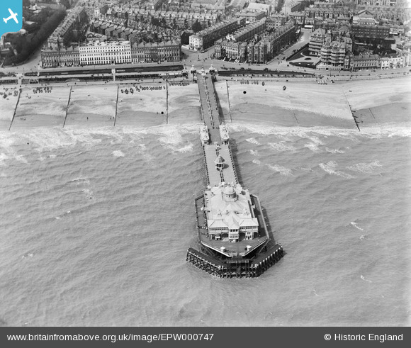
EPW000747 ENGLAND (1920). Grand Parade, Eastbourne, from the south-west, 1920
© Copyright OpenStreetMap contributors and licensed by the OpenStreetMap Foundation. 2025. Cartography is licensed as CC BY-SA.
Nearby Images (13)
Details
| Title | [EPW000747] Grand Parade, Eastbourne, from the south-west, 1920 |
| Reference | EPW000747 |
| Date | April-1920 |
| Link | |
| Place name | EASTBOURNE |
| Parish | |
| District | |
| Country | ENGLAND |
| Easting / Northing | 561383, 98288 |
| Longitude / Latitude | 0.28851129665595, 50.761143601211 |
| National Grid Reference | TV614983 |
Pins
 Mikeo1938 |
Sunday 15th of April 2018 06:23:22 PM | |
 Alan McFaden |
Monday 22nd of July 2013 11:30:13 AM | |
 Alan McFaden |
Monday 22nd of July 2013 11:29:17 AM | |
 Alan McFaden |
Monday 22nd of July 2013 11:28:06 AM | |
 Alan McFaden |
Monday 22nd of July 2013 11:27:29 AM | |
 Alan McFaden |
Monday 22nd of July 2013 11:26:21 AM | |
 Alan McFaden |
Monday 22nd of July 2013 11:25:42 AM | |
 Alan McFaden |
Monday 22nd of July 2013 11:24:58 AM |
User Comment Contributions
 Eastbourne Pier Fire Damage September 2014 |
 Alan McFaden |
Wednesday 8th of October 2014 10:33:47 AM |
 Chris |
Saturday 30th of June 2012 10:56:48 PM | |
To the extreme left can be seen what is now Terminus Road, formerly Victoria Place. The maisonettes, Victoria Mansions, are yet to be built on the western side of the road. |
 Mikeo1938 |
Tuesday 26th of June 2012 06:36:41 PM |


![[EPW000747] Grand Parade, Eastbourne, from the south-west, 1920](http://britainfromabove.org.uk/sites/all/libraries/aerofilms-images/public/100x100/EPW/000/EPW000747.jpg)
![[EPW051369] The Wish Tower (Martello Tower No 73), Eastbourne, 1936](http://britainfromabove.org.uk/sites/all/libraries/aerofilms-images/public/100x100/EPW/051/EPW051369.jpg)
![[EPW039413] The Wish Tower (Martello Tower no 73), the Grand Parade and the seafront, Eastbourne, from the south, 1932](http://britainfromabove.org.uk/sites/all/libraries/aerofilms-images/public/100x100/EPW/039/EPW039413.jpg)
![[EAW026327] The Wish Tower (Martello Tower No. 73), Eastbourne, 1949](http://britainfromabove.org.uk/sites/all/libraries/aerofilms-images/public/100x100/EAW/026/EAW026327.jpg)
![[EPW000745] Wilmington Square and the Wish Tower, Eastbourne, 1920](http://britainfromabove.org.uk/sites/all/libraries/aerofilms-images/public/100x100/EPW/000/EPW000745.jpg)
![[EAW006142] Seafront hotels along Grand Parade, the bandstand and the beach, Eastbourne, from the south-east, 1947](http://britainfromabove.org.uk/sites/all/libraries/aerofilms-images/public/100x100/EAW/006/EAW006142.jpg)
![[EPW035320] The Wish Tower, Pier and Grand Parade, Eastbourne, from the south-west, 1931](http://britainfromabove.org.uk/sites/all/libraries/aerofilms-images/public/100x100/EPW/035/EPW035320.jpg)
![[EAW006614] The seafront and town, Eastbourne, from the south, 1947](http://britainfromabove.org.uk/sites/all/libraries/aerofilms-images/public/100x100/EAW/006/EAW006614.jpg)
![[EAW022971] Grand Parade and the town, Eastbourne, from the south-east, 1949](http://britainfromabove.org.uk/sites/all/libraries/aerofilms-images/public/100x100/EAW/022/EAW022971.jpg)
![[EAW022969] Grand Parade and the town, Eastbourne, from the east, 1949](http://britainfromabove.org.uk/sites/all/libraries/aerofilms-images/public/100x100/EAW/022/EAW022969.jpg)
![[EAW006145] Hotels along Grand Parade, the seafront and the town, Eastbourne, from the south-east, 1947](http://britainfromabove.org.uk/sites/all/libraries/aerofilms-images/public/100x100/EAW/006/EAW006145.jpg)
![[EPW000104] The Grand Hotel, Eastbourne, 1920](http://britainfromabove.org.uk/sites/all/libraries/aerofilms-images/public/100x100/EPW/000/EPW000104.jpg)
![[EPW035323] The Cavendish Hotel and Grand Parade, Eastbourne, from the south-east, 1931](http://britainfromabove.org.uk/sites/all/libraries/aerofilms-images/public/100x100/EPW/035/EPW035323.jpg)


