
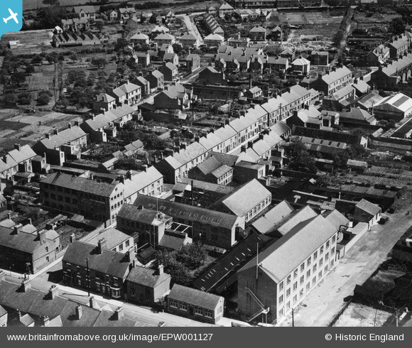
EPW001127 ENGLAND (1920). New Street and environs, Earl Shilton, 1920
© Copyright OpenStreetMap contributors and licensed by the OpenStreetMap Foundation. 2025. Cartography is licensed as CC BY-SA.
Nearby Images (9)
EPW001127

EAW001127

EAW001132

EAW001131

EPW001129

EAW001129

EAW001130

EAW001128

EPW001128

Details
| Title | [EPW001127] New Street and environs, Earl Shilton, 1920 |
| Reference | EPW001127 |
| Date | May-1920 |
| Link | |
| Place name | EARL SHILTON |
| Parish | EARL SHILTON |
| District | |
| Country | ENGLAND |
| Easting / Northing | 446053, 297531 |
| Longitude / Latitude | -1.3203833413109, 52.573288721362 |
| National Grid Reference | SP461975 |
Pins
 Class31 |
Wednesday 25th of July 2012 04:40:48 PM | |
Class31 |
Wednesday 25th of July 2012 04:40:25 PM | |
Class31 |
Wednesday 25th of July 2012 04:38:38 PM | |
Class31 |
Wednesday 25th of July 2012 04:37:33 PM | |
Class31 |
Wednesday 25th of July 2012 04:36:41 PM | |
Class31 |
Wednesday 25th of July 2012 04:36:22 PM | |
Class31 |
Wednesday 25th of July 2012 04:35:40 PM | |
 EastMarple1 |
Thursday 28th of June 2012 05:46:04 PM |
User Comment Contributions
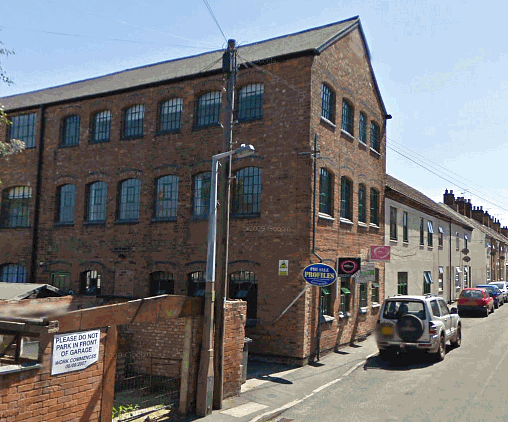
Dear all, That’s great; we’ve reviewed your comments and thanks to your help we can update the catalogue. The revised record with the correct location will appear here in due course. It's especially useful having the ground shot of one of the factory buildings, thanks Hazy. Yours, Katy Britain from Above Cataloguing Team Leader |
Katy Whitaker |
Tuesday 23rd of October 2012 10:01:40 AM |
View looking East from above Hinckley Road, Earl Shilton. |
Class31 |
Wednesday 25th of July 2012 04:44:26 PM |
 This is Earl Shilton. The three roads leading towards the top of the picture are, left to right, Melton Street, New Street and Rossendale Road, with Hinckley Road running along the bottom of the picture. The A.Abbott factory is still there, although it has been converted into flats. Most of the houses surrounding the Abbott factory are still there, although the block nearest the camera, including the large building with the fire escape, are now replaced by a industrial unit. In the background you can see Byron Street crossing the photo, houses on James Street under construction, with Metcalfe Street running off upwards towards Station Road, which crosses the picture right at the back. |
Hazycosmicvibe |
Tuesday 10th of July 2012 12:37:30 AM |
Spot on hazy - good confirmation as well :C) |
Eton Slaphead |
Tuesday 10th of July 2012 12:37:30 AM |
Unfortunately the factories are most likely not there anymore and will not show up on Google maps. Many such of these, probably boot and shoe factories originally, have been pulled down in Leics and Northants |
EastMarple1 |
Sunday 1st of July 2012 10:52:47 AM |
Vehicles in picture look like late 1930's, certainly later than 1920's. |
NE2 3PN |
Saturday 30th of June 2012 08:33:11 PM |
Shop at top right has a sign on the side "Everards Ales" Everards being a Leicestershire brewery |
Eton Slaphead |
Thursday 28th of June 2012 09:25:06 PM |
This image and EPW001128 are of the same location. |
co_fragment |
Tuesday 26th of June 2012 07:54:22 PM |