
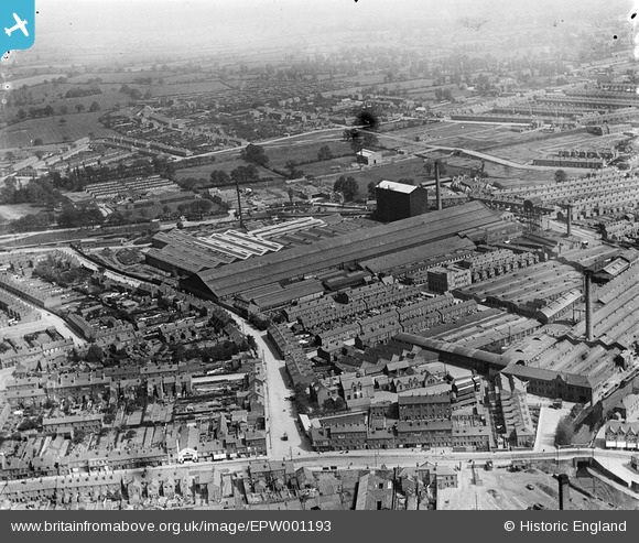
EPW001193 ENGLAND (1920). Factories, Red Lane, Great Heath, Coventry, 1920
© Copyright OpenStreetMap contributors and licensed by the OpenStreetMap Foundation. 2025. Cartography is licensed as CC BY-SA.
Nearby Images (13)
EPW001193

EPW033965

EPW033956

EPW010519

EPW033959

EPW033958

EPW010520

EPW010518

EPW033964

EPW061097

EPW061217

EPW033963

EPW033957

Details
| Title | [EPW001193] Factories, Red Lane, Great Heath, Coventry, 1920 |
| Reference | EPW001193 |
| Date | May-1920 |
| Link | |
| Place name | COVENTRY |
| Parish | |
| District | |
| Country | ENGLAND |
| Easting / Northing | 434618, 280246 |
| Longitude / Latitude | -1.4909222195356, 52.418733949852 |
| National Grid Reference | SP346802 |
Pins
 CovKid51 |
Tuesday 27th of June 2017 04:26:40 PM | |
CovKid51 |
Tuesday 27th of June 2017 04:12:44 PM | |
 |
CovKid51 |
Tuesday 27th of June 2017 03:57:10 PM |
CovKid51 |
Tuesday 27th of June 2017 03:12:23 PM | |
CovKid51 |
Tuesday 27th of June 2017 03:09:26 PM | |
CovKid51 |
Sunday 25th of June 2017 10:52:12 PM | |
CovKid51 |
Sunday 25th of June 2017 10:31:46 PM | |
CovKid51 |
Sunday 25th of June 2017 10:23:24 PM | |
Bob Curtis |
Thursday 31st of March 2016 11:18:10 AM | |
Bob Curtis |
Thursday 31st of March 2016 11:17:02 AM | |
Bob Curtis |
Thursday 31st of March 2016 11:15:26 AM | |
Bob Curtis |
Thursday 31st of March 2016 11:13:34 AM | |
Bob Curtis |
Thursday 31st of March 2016 11:08:44 AM | |
Derrickarthur |
Wednesday 9th of December 2015 12:52:38 AM | |
Jack Cobb |
Wednesday 3rd of December 2014 03:38:06 PM | |
Coventry kid |
Tuesday 22nd of July 2014 03:46:12 PM | |
Derrickarthur |
Tuesday 18th of March 2014 10:31:31 PM | |
 offshoredaze |
Sunday 29th of December 2013 03:08:07 PM | |
Tezzacov |
Monday 10th of June 2013 09:48:54 AM | |
Tezzacov |
Monday 10th of June 2013 09:48:49 AM | |
Tezzacov |
Saturday 1st of June 2013 07:42:05 PM | |
Tezzacov |
Saturday 1st of June 2013 07:39:48 PM | |
tezzacov |
Saturday 25th of May 2013 11:46:31 AM | |
Later (around late forties/early fifties) converted into St. Finbarr's Irish Social Club. |
Jack Cobb |
Wednesday 3rd of December 2014 03:34:15 PM |
JG |
Saturday 2nd of February 2013 12:20:50 PM | |
JG |
Saturday 2nd of February 2013 12:20:19 PM | |
JG |
Saturday 2nd of February 2013 12:19:53 PM | |
JG |
Saturday 2nd of February 2013 12:17:40 PM |

User Comment Contributions
 Because of the occupation of the Ordnance Works by the Admiralty from 1938 this area suffered badly from the bombing |
Bob Curtis |
Monday 4th of April 2016 11:05:39 AM |
Coventry Ordnance Works |
Lynda Tubbs |
Thursday 10th of July 2014 02:48:11 PM |
The road running left to right across the bottom of the photo is Stoney Stanton Road. The large building in the centre is the Ordnance Works. |
jvb |
Wednesday 16th of January 2013 09:53:28 PM |