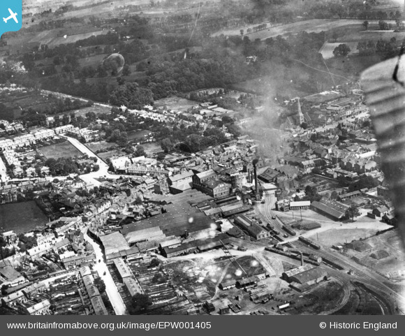
EPW001405 ENGLAND (1920). The Ind Coope and Co Romford Brewery and environs, Romford, 1920. This image has been produced from a print.
© Copyright OpenStreetMap contributors and licensed by the OpenStreetMap Foundation. 2025. Cartography is licensed as CC BY-SA.
Nearby Images (7)
Details
| Title | [EPW001405] The Ind Coope and Co Romford Brewery and environs, Romford, 1920. This image has been produced from a print. |
| Reference | EPW001405 |
| Date | 7-June-1920 |
| Link | |
| Place name | ROMFORD |
| Parish | |
| District | |
| Country | ENGLAND |
| Easting / Northing | 551082, 188841 |
| Longitude / Latitude | 0.18061182853972, 51.577681952286 |
| National Grid Reference | TQ511888 |
Pins
 OldManBrook |
Tuesday 19th of September 2023 10:34:37 PM | |
 jonnyace |
Tuesday 18th of July 2023 10:17:31 PM | |
 jonnyace |
Tuesday 18th of July 2023 10:16:31 PM | |
 n1dom |
Saturday 8th of August 2015 06:25:44 AM | |
 John Wass |
Monday 22nd of June 2015 03:31:27 PM | |
 GeoffR |
Tuesday 20th of January 2015 05:25:09 PM | |
 Chelsea61 |
Wednesday 26th of November 2014 06:58:25 PM |
User Comment Contributions
 GeoffR |
Tuesday 20th of January 2015 05:28:08 PM |


![[EPW001405] The Ind Coope and Co Romford Brewery and environs, Romford, 1920. This image has been produced from a print.](http://britainfromabove.org.uk/sites/all/libraries/aerofilms-images/public/100x100/EPW/001/EPW001405.jpg)
![[EPW001390] The Market Place and town centre, Romford, 1920](http://britainfromabove.org.uk/sites/all/libraries/aerofilms-images/public/100x100/EPW/001/EPW001390.jpg)
![[EPW006268] The Market Place and St Edward the Confessor's Church, Romford, 1921](http://britainfromabove.org.uk/sites/all/libraries/aerofilms-images/public/100x100/EPW/006/EPW006268.jpg)
![[EPW001391] General view of the town centre, Romford, 1920](http://britainfromabove.org.uk/sites/all/libraries/aerofilms-images/public/100x100/EPW/001/EPW001391.jpg)
![[EPW001394] The Market Place and Cattle Market, Romford, 1920](http://britainfromabove.org.uk/sites/all/libraries/aerofilms-images/public/100x100/EPW/001/EPW001394.jpg)
![[EPW001393] General view of the town centre, Romford, from the south, 1920](http://britainfromabove.org.uk/sites/all/libraries/aerofilms-images/public/100x100/EPW/001/EPW001393.jpg)
![[EPW001392] General view of the town centre, Romford, from the south-west, 1920](http://britainfromabove.org.uk/sites/all/libraries/aerofilms-images/public/100x100/EPW/001/EPW001392.jpg)
