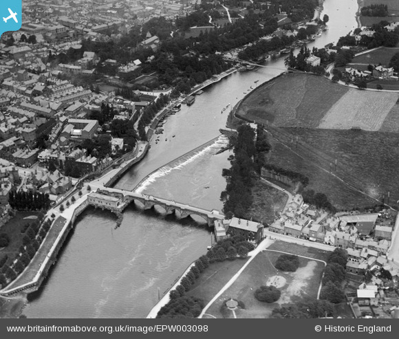
EPW003098 ENGLAND (1920). The Dee Bridge, Chester, 1920
© Copyright OpenStreetMap contributors and licensed by the OpenStreetMap Foundation. 2025. Cartography is licensed as CC BY-SA.
Nearby Images (11)
Details
| Title | [EPW003098] The Dee Bridge, Chester, 1920 |
| Reference | EPW003098 |
| Date | July-1920 |
| Link | |
| Place name | CHESTER |
| Parish | |
| District | |
| Country | ENGLAND |
| Easting / Northing | 340785, 365830 |
| Longitude / Latitude | -2.8862603039469, 53.185977722953 |
| National Grid Reference | SJ408658 |
Pins
 RachelMC |
Friday 15th of May 2015 08:40:27 PM | |
 London1955 |
Saturday 13th of July 2013 06:59:32 AM | |
 MB |
Tuesday 27th of November 2012 11:15:13 AM | |
 MB |
Tuesday 27th of November 2012 11:14:06 AM | |
 MB |
Tuesday 27th of November 2012 11:13:42 AM | |
 MB |
Tuesday 27th of November 2012 11:12:36 AM | |
 MB |
Tuesday 27th of November 2012 11:11:53 AM | |
 MB |
Tuesday 27th of November 2012 10:59:06 AM | |
 MB |
Tuesday 27th of November 2012 10:58:21 AM | |
 MB |
Tuesday 27th of November 2012 10:54:29 AM | |
 MB |
Tuesday 27th of November 2012 10:52:58 AM | |
 MB |
Tuesday 27th of November 2012 10:52:15 AM | |
 MB |
Tuesday 27th of November 2012 10:51:34 AM | |
Actually just a shelter placed on top of a sandstone outcrop of the old Roman Quarry. This was never used as a bandstand. |
 RachelMC |
Friday 15th of May 2015 08:38:36 PM |
 MB |
Tuesday 27th of November 2012 10:51:02 AM | |
 MB |
Tuesday 27th of November 2012 10:49:25 AM | |
 MB |
Tuesday 27th of November 2012 10:47:28 AM | |
 MB |
Tuesday 27th of November 2012 10:46:56 AM | |
 MB |
Tuesday 27th of November 2012 10:42:41 AM | |
 MB |
Tuesday 27th of November 2012 10:42:04 AM | |
 MB |
Tuesday 27th of November 2012 10:41:47 AM | |
 MB |
Tuesday 27th of November 2012 10:31:52 AM |


![[EPW003098] The Dee Bridge, Chester, 1920](http://britainfromabove.org.uk/sites/all/libraries/aerofilms-images/public/100x100/EPW/003/EPW003098.jpg)
![[EPW004004] The Dee Bridge, Chester, 1920](http://britainfromabove.org.uk/sites/all/libraries/aerofilms-images/public/100x100/EPW/004/EPW004004.jpg)
![[EPW058012] St Mary's Church, Dee Bridge and the town, Chester, 1938](http://britainfromabove.org.uk/sites/all/libraries/aerofilms-images/public/100x100/EPW/058/EPW058012.jpg)
![[EPW004002] Dee Bridge and Lower Bridge Street, Chester, 1920. This image has been produced from a print.](http://britainfromabove.org.uk/sites/all/libraries/aerofilms-images/public/100x100/EPW/004/EPW004002.jpg)
![[EPW040163] The Suspension Bridge, Dee Bridge and Grosvenor Bridge on the River Dee and environs, Chester, 1932](http://britainfromabove.org.uk/sites/all/libraries/aerofilms-images/public/100x100/EPW/040/EPW040163.jpg)
![[EPW058003] The River Dee and the city, Chester, 1938. This image has been produced from a print.](http://britainfromabove.org.uk/sites/all/libraries/aerofilms-images/public/100x100/EPW/058/EPW058003.jpg)
![[EPW003088] Lower Bridge Street and environs, Chester, 1920. This image has been produced from a copy-negative.](http://britainfromabove.org.uk/sites/all/libraries/aerofilms-images/public/100x100/EPW/003/EPW003088.jpg)
![[EPW003095] Queen's Park Bridge, Chester, 1920](http://britainfromabove.org.uk/sites/all/libraries/aerofilms-images/public/100x100/EPW/003/EPW003095.jpg)
![[EPW029590] City High School, Chester, 1929. This image has been produced from a print.](http://britainfromabove.org.uk/sites/all/libraries/aerofilms-images/public/100x100/EPW/029/EPW029590.jpg)
![[EPW058005] The Castle, Dee Bridge and the town, Chester, 1938. This image has been produced from a damaged negative.](http://britainfromabove.org.uk/sites/all/libraries/aerofilms-images/public/100x100/EPW/058/EPW058005.jpg)
![[EPW005886] Queen's Park Suspension Bridge and the River Dee, Chester, 1921. This image has been produced from a copy-negative.](http://britainfromabove.org.uk/sites/all/libraries/aerofilms-images/public/100x100/EPW/005/EPW005886.jpg)
