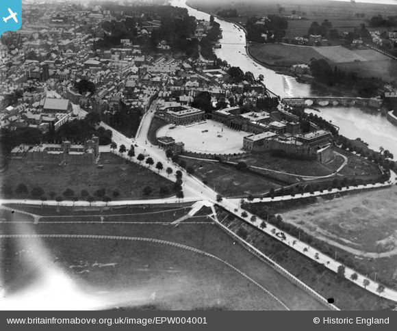
EPW004001 ENGLAND (1920). Chester Castle, Chester, 1920
© Copyright OpenStreetMap contributors and licensed by the OpenStreetMap Foundation. 2025. Cartography is licensed as CC BY-SA.
Nearby Images (12)
Details
| Title | [EPW004001] Chester Castle, Chester, 1920 |
| Reference | EPW004001 |
| Date | July-1920 |
| Link | |
| Place name | CHESTER |
| Parish | CHESTER CASTLE |
| District | |
| Country | ENGLAND |
| Easting / Northing | 340398, 365809 |
| Longitude / Latitude | -2.8920477803922, 53.185745734416 |
| National Grid Reference | SJ404658 |
Pins
 Class31 |
Friday 6th of November 2015 08:54:07 PM | |
 Class31 |
Friday 6th of November 2015 08:52:42 PM | |
 Ramblinjohn |
Tuesday 3rd of July 2012 01:03:12 PM | |
 Ramblinjohn |
Tuesday 3rd of July 2012 01:02:25 PM | |
 Ramblinjohn |
Tuesday 3rd of July 2012 01:00:32 PM |
User Comment Contributions
 BruceR |
Saturday 2nd of February 2013 08:52:36 PM | |
 Robert - Cumbria |
Wednesday 27th of June 2012 05:54:57 PM |


![[EPW004001] Chester Castle, Chester, 1920](http://britainfromabove.org.uk/sites/all/libraries/aerofilms-images/public/100x100/EPW/004/EPW004001.jpg)
![[EPW003092] Chester Castle, Chester, 1920](http://britainfromabove.org.uk/sites/all/libraries/aerofilms-images/public/100x100/EPW/003/EPW003092.jpg)
![[EPW003087] The Castle, Chester, 1920. This image has been produced from a copy-negative.](http://britainfromabove.org.uk/sites/all/libraries/aerofilms-images/public/100x100/EPW/003/EPW003087.jpg)
![[EAW013774] Chester Castle and the city centre, Chester, 1948](http://britainfromabove.org.uk/sites/all/libraries/aerofilms-images/public/100x100/EAW/013/EAW013774.jpg)
![[EPW029882] Chester Castle and Assize Courts, Chester, 1929](http://britainfromabove.org.uk/sites/all/libraries/aerofilms-images/public/100x100/EPW/029/EPW029882.jpg)
![[EAW013773] Grosvenor Bridge, Dee Bridge and the city centre, Chester, 1948](http://britainfromabove.org.uk/sites/all/libraries/aerofilms-images/public/100x100/EAW/013/EAW013773.jpg)
![[EPW036916] Chester Castle and Assize Courts, Chester, 1931](http://britainfromabove.org.uk/sites/all/libraries/aerofilms-images/public/100x100/EPW/036/EPW036916.jpg)
![[EAW013775] Chester Castle, County Hall and St Mary on the Hill Church, Chester, 1948. This image has been produced from a damaged negative.](http://britainfromabove.org.uk/sites/all/libraries/aerofilms-images/public/100x100/EAW/013/EAW013775.jpg)
![[EPW058008] The city, Chester, from the south-west, 1938. This image has been produced from a copy-negative.](http://britainfromabove.org.uk/sites/all/libraries/aerofilms-images/public/100x100/EPW/058/EPW058008.jpg)
![[EPW058005] The Castle, Dee Bridge and the town, Chester, 1938. This image has been produced from a damaged negative.](http://britainfromabove.org.uk/sites/all/libraries/aerofilms-images/public/100x100/EPW/058/EPW058005.jpg)
![[EPW003088] Lower Bridge Street and environs, Chester, 1920. This image has been produced from a copy-negative.](http://britainfromabove.org.uk/sites/all/libraries/aerofilms-images/public/100x100/EPW/003/EPW003088.jpg)
![[EPW011201] The Grosvenor Bridge and the River Dee, Chester, 1924](http://britainfromabove.org.uk/sites/all/libraries/aerofilms-images/public/100x100/EPW/011/EPW011201.jpg)
