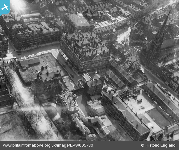
EPW005730 ENGLAND (1921). Barker & Co and Kensington High Street, Kensington, 1921
© Copyright OpenStreetMap contributors and licensed by the OpenStreetMap Foundation. 2025. Cartography is licensed as CC BY-SA.
Nearby Images (14)
Details
| Title | [EPW005730] Barker & Co and Kensington High Street, Kensington, 1921 |
| Reference | EPW005730 |
| Date | March-1921 |
| Link | |
| Place name | KENSINGTON |
| Parish | |
| District | |
| Country | ENGLAND |
| Easting / Northing | 525708, 179741 |
| Longitude / Latitude | -0.1886523362549, 51.502123285509 |
| National Grid Reference | TQ257797 |
Pins
 The Laird |
Thursday 26th of June 2014 03:45:04 PM | |
 The Laird |
Thursday 26th of June 2014 03:41:19 PM |


![[EPW005730] Barker & Co and Kensington High Street, Kensington, 1921](http://britainfromabove.org.uk/sites/all/libraries/aerofilms-images/public/100x100/EPW/005/EPW005730.jpg)
![[EAW022729] Kensington High Street and Kensington Gardens, Kensington, 1949](http://britainfromabove.org.uk/sites/all/libraries/aerofilms-images/public/100x100/EAW/022/EAW022729.jpg)
![[EPW007764] Kensington High Street, St Mary Abbott's Church and environs, Kensington, 1922](http://britainfromabove.org.uk/sites/all/libraries/aerofilms-images/public/100x100/EPW/007/EPW007764.jpg)
![[EPW007761] St Mary Abbott's Church and Kensington High Street and environs, Kensington, 1922](http://britainfromabove.org.uk/sites/all/libraries/aerofilms-images/public/100x100/EPW/007/EPW007761.jpg)
![[EPW007763] Kensington High Street and environs, Kensington, 1922](http://britainfromabove.org.uk/sites/all/libraries/aerofilms-images/public/100x100/EPW/007/EPW007763.jpg)
![[EPW005724] St Mary Abbots Church and environs, Kensington, 1921. This image has been produced from a print.](http://britainfromabove.org.uk/sites/all/libraries/aerofilms-images/public/100x100/EPW/005/EPW005724.jpg)
![[EPW060790] Central London from Holland Park towards the Isle of Dogs, Kensington, from the west, 1939](http://britainfromabove.org.uk/sites/all/libraries/aerofilms-images/public/100x100/EPW/060/EPW060790.jpg)
![[EPW007759] Kensington High Street and environs, Kensington, 1922](http://britainfromabove.org.uk/sites/all/libraries/aerofilms-images/public/100x100/EPW/007/EPW007759.jpg)
![[EPW007762] Kensington High Street and environs, Kensington, 1922](http://britainfromabove.org.uk/sites/all/libraries/aerofilms-images/public/100x100/EPW/007/EPW007762.jpg)
![[EPW007758] Kensington High Street and environs, Kensington, 1922](http://britainfromabove.org.uk/sites/all/libraries/aerofilms-images/public/100x100/EPW/007/EPW007758.jpg)
![[EPW045416] Kensington High Street and environs, Kensington, 1934](http://britainfromabove.org.uk/sites/all/libraries/aerofilms-images/public/100x100/EPW/045/EPW045416.jpg)
![[EPW007756] Kensington High Street and environs, Kensington, 1922](http://britainfromabove.org.uk/sites/all/libraries/aerofilms-images/public/100x100/EPW/007/EPW007756.jpg)
![[EPW007760] Kensington High Street and environs, Kensington, 1922](http://britainfromabove.org.uk/sites/all/libraries/aerofilms-images/public/100x100/EPW/007/EPW007760.jpg)
![[EPW007755] Kensington High Street and environs, Kensington, 1922](http://britainfromabove.org.uk/sites/all/libraries/aerofilms-images/public/100x100/EPW/007/EPW007755.jpg)