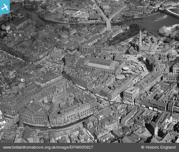
EPW005817 ENGLAND (1921). The Market Hall and environs, Derby, 1921
© Copyright OpenStreetMap contributors and licensed by the OpenStreetMap Foundation. 2025. Cartography is licensed as CC BY-SA.
Nearby Images (12)
Details
| Title | [EPW005817] The Market Hall and environs, Derby, 1921 |
| Reference | EPW005817 |
| Date | March-1921 |
| Link | |
| Place name | DERBY |
| Parish | |
| District | |
| Country | ENGLAND |
| Easting / Northing | 435305, 336242 |
| Longitude / Latitude | -1.4748182699969, 52.922113345125 |
| National Grid Reference | SK353362 |
Pins
 John Wass |
Sunday 5th of November 2017 07:50:57 PM | |
 MB |
Monday 24th of October 2016 12:14:58 PM | |
 MB |
Monday 24th of October 2016 12:14:33 PM | |
 MB |
Monday 24th of October 2016 12:14:05 PM | |
 MB |
Monday 24th of October 2016 12:13:39 PM | |
 Billy Turner |
Sunday 7th of June 2015 09:52:05 PM | |
 Billy Turner |
Sunday 7th of June 2015 09:42:05 PM | |
 Billy Turner |
Sunday 7th of June 2015 09:35:28 PM | |
 Triggy |
Tuesday 2nd of June 2015 06:54:30 PM | |
 Peter Kazmierczak |
Sunday 23rd of November 2014 06:37:44 PM | |
 Peter Kazmierczak |
Sunday 6th of October 2013 03:57:38 PM | |
 Gordy |
Saturday 26th of January 2013 02:36:53 AM | |
 Gordy |
Saturday 26th of January 2013 02:36:08 AM | |
 Gordy |
Saturday 26th of January 2013 02:35:29 AM | |
 Gordy |
Saturday 26th of January 2013 02:34:59 AM | |
 Gordy |
Saturday 26th of January 2013 02:33:54 AM | |
 Gordy |
Saturday 26th of January 2013 02:33:15 AM | |
 Gordy |
Saturday 26th of January 2013 02:31:47 AM | |
 Gordy |
Saturday 26th of January 2013 02:30:56 AM | |
 almoffat |
Saturday 30th of June 2012 06:44:53 PM | |
 almoffat |
Saturday 30th of June 2012 06:39:23 PM | |
 NJ Rippon |
Tuesday 26th of June 2012 02:44:48 PM | |
 NJ Rippon |
Tuesday 26th of June 2012 02:44:14 PM | |
Cox's Shot Tower was pulled down in 1931/2 to make way for the bus station. |
 melgibbs |
Thursday 20th of June 2013 04:23:07 PM |
 NJ Rippon |
Tuesday 26th of June 2012 02:43:47 PM | |
 sdramm |
Monday 25th of June 2012 10:10:10 PM |

![[EPW005817] The Market Hall and environs, Derby, 1921](http://britainfromabove.org.uk/sites/all/libraries/aerofilms-images/public/100x100/EPW/005/EPW005817.jpg)
![[EPW055021] Victoria Street and environs, Derby, 1937](http://britainfromabove.org.uk/sites/all/libraries/aerofilms-images/public/100x100/EPW/055/EPW055021.jpg)
![[EPW055028] The city centre and Exeter Bridge, Derby, 1937](http://britainfromabove.org.uk/sites/all/libraries/aerofilms-images/public/100x100/EPW/055/EPW055028.jpg)
![[EPW005815] Iron Gate and environs, Derby, 1921](http://britainfromabove.org.uk/sites/all/libraries/aerofilms-images/public/100x100/EPW/005/EPW005815.jpg)
![[EAW004658] The city centre, Derby, 1947](http://britainfromabove.org.uk/sites/all/libraries/aerofilms-images/public/100x100/EAW/004/EAW004658.jpg)
![[EAW004662] The city centre, Derby, from the south-west, 1947](http://britainfromabove.org.uk/sites/all/libraries/aerofilms-images/public/100x100/EAW/004/EAW004662.jpg)
![[EAW004660] The city centre, Derby, from the west, 1947](http://britainfromabove.org.uk/sites/all/libraries/aerofilms-images/public/100x100/EAW/004/EAW004660.jpg)
![[EAW015423] The city centre and St Mary's Goods Depot, Derby, 1948. This image has been produced from a print.](http://britainfromabove.org.uk/sites/all/libraries/aerofilms-images/public/100x100/EAW/015/EAW015423.jpg)
![[EPW041813] Riverside Gardens area and environs, Derby, 1933](http://britainfromabove.org.uk/sites/all/libraries/aerofilms-images/public/100x100/EPW/041/EPW041813.jpg)
![[EPW041812] The Cattle Market and bridges over the River, Derby, 1933](http://britainfromabove.org.uk/sites/all/libraries/aerofilms-images/public/100x100/EPW/041/EPW041812.jpg)
![[EPW005816] The Central Library and Wardwick Street, Derby, 1921](http://britainfromabove.org.uk/sites/all/libraries/aerofilms-images/public/100x100/EPW/005/EPW005816.jpg)
![[EAW004663] The city centre, Derby, from the west, 1947](http://britainfromabove.org.uk/sites/all/libraries/aerofilms-images/public/100x100/EAW/004/EAW004663.jpg)
