
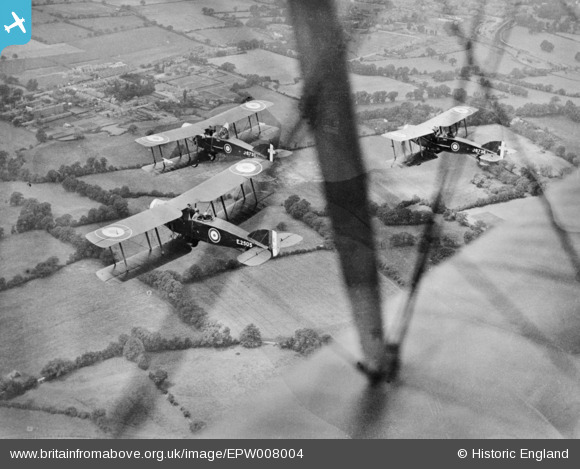
EPW008004 ENGLAND (1922). Three Bristol F.2b aircraft in flight including J6730, J6736 and E3505, Burnt Oak, 1922. This image has been produced from a copy-negative.
© Copyright OpenStreetMap contributors and licensed by the OpenStreetMap Foundation. 2025. Cartography is licensed as CC BY-SA.
Nearby Images (5)
EPW008004

EAW033378

EAW033379

EAW027668
 in flight over the Watling Park area, Burnt Oak, from the west, 1949")
EPW019192

Details
| Title | [EPW008004] Three Bristol F.2b aircraft in flight including J6730, J6736 and E3505, Burnt Oak, 1922. This image has been produced from a copy-negative. |
| Reference | EPW008004 |
| Date | May-1922 |
| Link | |
| Place name | BURNT OAK |
| Parish | |
| District | |
| Country | ENGLAND |
| Easting / Northing | 520554, 191166 |
| Longitude / Latitude | -0.25896243636838, 51.605937415793 |
| National Grid Reference | TQ206912 |
Pins
 J |
Tuesday 21st of April 2020 11:31:44 PM | |
colsouth111 |
Thursday 11th of September 2014 10:39:36 AM | |
colsouth111 |
Thursday 11th of September 2014 10:38:04 AM | |
colsouth111 |
Thursday 11th of September 2014 10:37:05 AM | |
colsouth111 |
Thursday 11th of September 2014 10:35:36 AM | |
colsouth111 |
Thursday 11th of September 2014 10:34:02 AM | |
colsouth111 |
Thursday 11th of September 2014 10:33:09 AM | |
colsouth111 |
Thursday 11th of September 2014 10:32:26 AM | |
colsouth111 |
Thursday 11th of September 2014 10:31:29 AM | |
colsouth111 |
Thursday 11th of September 2014 10:30:38 AM | |
colsouth111 |
Thursday 11th of September 2014 10:29:32 AM |
User Comment Contributions
 Good to see another early shot of Burnt Oak, albeit rather distant as the aircraft are the stars of this picture. Close perusal of the distance allows us to see Burnt Oak before construction of the hospital and the Northern Line to Edgware. Just look at all those surrounding fields! I wonder if there are any other such early Burnt Oak images yet to be released. |
colsouth111 |
Thursday 11th of September 2014 10:48:08 AM |