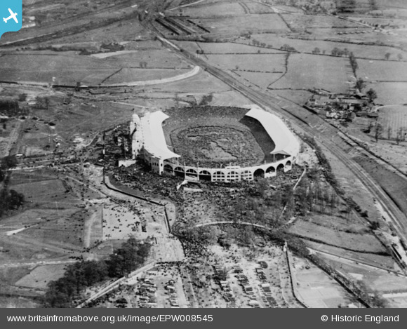
EPW008545 ENGLAND (1923). The British Empire Exhibition Stadium (Wembley Stadium), Wembley Park, 1923. This image has been produced from a copy-negative.
© Copyright OpenStreetMap contributors and licensed by the OpenStreetMap Foundation. 2025. Cartography is licensed as CC BY-SA.
Nearby Images (48)
Details
| Title | [EPW008545] The British Empire Exhibition Stadium (Wembley Stadium), Wembley Park, 1923. This image has been produced from a copy-negative. |
| Reference | EPW008545 |
| Date | 1923 |
| Link | |
| Place name | WEMBLEY PARK |
| Parish | |
| District | |
| Country | ENGLAND |
| Easting / Northing | 519326, 185479 |
| Longitude / Latitude | -0.27862142362685, 51.555082471399 |
| National Grid Reference | TQ193855 |
Pins
 The Laird |
Tuesday 19th of January 2016 05:08:54 PM |


![[EPW046909] Wembley Park, the FA Cup Final between Sheffield Wednesday and West Bromwich Albion, 1935](http://britainfromabove.org.uk/sites/all/libraries/aerofilms-images/public/100x100/EPW/046/EPW046909.jpg)
![[EPW011412] Wembley Park, Boxing Match between Tommy Gibbons and Jack Bloomfield, 1924](http://britainfromabove.org.uk/sites/all/libraries/aerofilms-images/public/100x100/EPW/011/EPW011412.jpg)
![[EPW017636] Wembley Park, The FA Cup Final between Cardiff City and Arsenal, 1927](http://britainfromabove.org.uk/sites/all/libraries/aerofilms-images/public/100x100/EPW/017/EPW017636.jpg)
![[EPW009655] The Empire Stadium, Wembley Park, 1923](http://britainfromabove.org.uk/sites/all/libraries/aerofilms-images/public/100x100/EPW/009/EPW009655.jpg)
![[EPW020862] Wembley Park, The FA Cup Final between Blackburn Rovers and Huddersfield Town, 1928](http://britainfromabove.org.uk/sites/all/libraries/aerofilms-images/public/100x100/EPW/020/EPW020862.jpg)
![[EPW010462] Wembley Park, Empire Day Celebrations in the Empire Stadium, 1924](http://britainfromabove.org.uk/sites/all/libraries/aerofilms-images/public/100x100/EPW/010/EPW010462.jpg)
![[EPW026433] Wembley, FA Cup Final between Bolton Wanderers and Portsmouth, 1929](http://britainfromabove.org.uk/sites/all/libraries/aerofilms-images/public/100x100/EPW/026/EPW026433.jpg)
![[EPW046913] Wembley Park, the FA Cup Final between Sheffield Wednesday and West Bromwich Albion, 1935](http://britainfromabove.org.uk/sites/all/libraries/aerofilms-images/public/100x100/EPW/046/EPW046913.jpg)
![[EPW010456] Wembley Park, Empire Day Celebrations in the Empire Stadium, 1924](http://britainfromabove.org.uk/sites/all/libraries/aerofilms-images/public/100x100/EPW/010/EPW010456.jpg)
![[EAW048878] Wembley Stadium, Wembley Park, 1953](http://britainfromabove.org.uk/sites/all/libraries/aerofilms-images/public/100x100/EAW/048/EAW048878.jpg)
![[EPW026438] Wembley, FA Cup Final between Bolton Wanderers and Portsmouth, 1929](http://britainfromabove.org.uk/sites/all/libraries/aerofilms-images/public/100x100/EPW/026/EPW026438.jpg)
![[EAW014141] The Empire (Wembley) Stadium, Wembley Park, 1948. This image has been produced from a damaged negative.](http://britainfromabove.org.uk/sites/all/libraries/aerofilms-images/public/100x100/EAW/014/EAW014141.jpg)
![[EAW018311] The Empire Stadium, Wembley Park, 1948. This image has been produced from a print.](http://britainfromabove.org.uk/sites/all/libraries/aerofilms-images/public/100x100/EAW/018/EAW018311.jpg)
![[EPW046905] Wembley Park, the FA Cup Final between Sheffield Wednesday and West Bromwich Albion, 1935](http://britainfromabove.org.uk/sites/all/libraries/aerofilms-images/public/100x100/EPW/046/EPW046905.jpg)
![[EPW010461] Wembley Park, Empire Day Celebrations in the Empire Stadium, 1924](http://britainfromabove.org.uk/sites/all/libraries/aerofilms-images/public/100x100/EPW/010/EPW010461.jpg)
![[EPW026431] Wembley, FA Cup Final between Bolton Wanderers and Portsmouth, 1929](http://britainfromabove.org.uk/sites/all/libraries/aerofilms-images/public/100x100/EPW/026/EPW026431.jpg)
![[EAW048879] Wembley Stadium and the Palace of Industry, Wembley Park, 1953](http://britainfromabove.org.uk/sites/all/libraries/aerofilms-images/public/100x100/EAW/048/EAW048879.jpg)
![[EPW034581] The Empire Stadium, Wembley Park, 1930](http://britainfromabove.org.uk/sites/all/libraries/aerofilms-images/public/100x100/EPW/034/EPW034581.jpg)
![[EAW018312] The Empire Stadium, Wembley Park, 1948. This image has been produced from a print.](http://britainfromabove.org.uk/sites/all/libraries/aerofilms-images/public/100x100/EAW/018/EAW018312.jpg)
![[EPW017635] Wembley Park, The FA Cup Final between Cardiff City and Arsenal, 1927](http://britainfromabove.org.uk/sites/all/libraries/aerofilms-images/public/100x100/EPW/017/EPW017635.jpg)
![[EPW010458] Wembley Park, Empire Day Celebrations in the Empire Stadium, 1924](http://britainfromabove.org.uk/sites/all/libraries/aerofilms-images/public/100x100/EPW/010/EPW010458.jpg)
![[EPW046907] Wembley Park, the FA Cup Final between Sheffield Wednesday and West Bromwich Albion, 1935](http://britainfromabove.org.uk/sites/all/libraries/aerofilms-images/public/100x100/EPW/046/EPW046907.jpg)
![[EAW048875] Wembley Stadium and the Palace of Industry, Wembley Park, 1953](http://britainfromabove.org.uk/sites/all/libraries/aerofilms-images/public/100x100/EAW/048/EAW048875.jpg)
![[EAW018313] The Empire Stadium, Wembley Park, 1948. This image has been produced from a print.](http://britainfromabove.org.uk/sites/all/libraries/aerofilms-images/public/100x100/EAW/018/EAW018313.jpg)
![[EPW010459] Wembley Park, Empire Day Celebrations in the Empire Stadium, 1924](http://britainfromabove.org.uk/sites/all/libraries/aerofilms-images/public/100x100/EPW/010/EPW010459.jpg)
![[EPW010457] Wembley Park, Empire Day Celebrations in the Empire Stadium, 1924](http://britainfromabove.org.uk/sites/all/libraries/aerofilms-images/public/100x100/EPW/010/EPW010457.jpg)
![[EPW010460] Wembley Park, Empire Day Celebrations in the Empire Stadium, 1924](http://britainfromabove.org.uk/sites/all/libraries/aerofilms-images/public/100x100/EPW/010/EPW010460.jpg)
![[EAW038566] Wembley Park, the Speedway semi-final of the London Cup (Wembley vs New Cross) at Wembley Stadium, 1951. This image has been produced from a print.](http://britainfromabove.org.uk/sites/all/libraries/aerofilms-images/public/100x100/EAW/038/EAW038566.jpg)
![[EPW008076] The British Empire Exhibition Stadium (Wembley Stadium) under construction, Wembley Park, from the north-west, 1922. This image has been produced from a copy-negative.](http://britainfromabove.org.uk/sites/all/libraries/aerofilms-images/public/100x100/EPW/008/EPW008076.jpg)
![[EPW020341] The Empire Stadium, Wembley Park, 1928](http://britainfromabove.org.uk/sites/all/libraries/aerofilms-images/public/100x100/EPW/020/EPW020341.jpg)
![[EPW026434] Wembley, FA Cup Final between Bolton Wanderers and Portsmouth, 1929](http://britainfromabove.org.uk/sites/all/libraries/aerofilms-images/public/100x100/EPW/026/EPW026434.jpg)
![[EAW017618] Wembley Park, crowds gathering at the Empire Stadium for the opening ceremony of the 1948 London Olympics, 1948. This image has been produced from a print.](http://britainfromabove.org.uk/sites/all/libraries/aerofilms-images/public/100x100/EAW/017/EAW017618.jpg)
![[EPW046910] Wembley Park, the FA Cup Final between Sheffield Wednesday and West Bromwich Albion, from the west, 1935](http://britainfromabove.org.uk/sites/all/libraries/aerofilms-images/public/100x100/EPW/046/EPW046910.jpg)
![[EPW009652] The British Empire Exhibition site, Wembley Park, from the south-west, 1923](http://britainfromabove.org.uk/sites/all/libraries/aerofilms-images/public/100x100/EPW/009/EPW009652.jpg)
![[EAW038567] Wembley Park, the Speedway semi-final of the London Cup (Wembley vs New Cross) at Wembley Stadium, 1951. This image has been produced from a print.](http://britainfromabove.org.uk/sites/all/libraries/aerofilms-images/public/100x100/EAW/038/EAW038567.jpg)
![[EAW017617] Wembley Park, crowds gathering at the Empire Stadium for the opening ceremony of the 1948 London Olympics, from the south, 1948. This image has been produced from a print.](http://britainfromabove.org.uk/sites/all/libraries/aerofilms-images/public/100x100/EAW/017/EAW017617.jpg)
![[EAW017619] Wembley Park, crowds gathering at the Empire Stadium for the opening ceremony of the 1948 London Olympics, 1948. This image has been produced from a print.](http://britainfromabove.org.uk/sites/all/libraries/aerofilms-images/public/100x100/EAW/017/EAW017619.jpg)
![[EPW017623] Wembley Park and Stadium, Wembley, 1927](http://britainfromabove.org.uk/sites/all/libraries/aerofilms-images/public/100x100/EPW/017/EPW017623.jpg)
![[EPW046914] Wembley Park, car parking at the FA Cup Final between Sheffield Wednesday and West Bromwich Albion, from the west, 1935](http://britainfromabove.org.uk/sites/all/libraries/aerofilms-images/public/100x100/EPW/046/EPW046914.jpg)
![[EPW035048] Wembley Park, Wembley Park before the start of the Cup Final between West Bromwich Albion and Birmingham, 1931. This image has been produced from a damaged negative.](http://britainfromabove.org.uk/sites/all/libraries/aerofilms-images/public/100x100/EPW/035/EPW035048.jpg)
![[EPW017625] Wembley Park and Stadium, Wembley, 1927](http://britainfromabove.org.uk/sites/all/libraries/aerofilms-images/public/100x100/EPW/017/EPW017625.jpg)
![[EPW017624] Wembley Park and Stadium, Wembley, 1927](http://britainfromabove.org.uk/sites/all/libraries/aerofilms-images/public/100x100/EPW/017/EPW017624.jpg)
![[EAW017620] Wembley Park, the Empire Stadium car park on the day of the opening ceremony of the 1948 London Olympics, 1948. This image has been produced from a print.](http://britainfromabove.org.uk/sites/all/libraries/aerofilms-images/public/100x100/EAW/017/EAW017620.jpg)
![[EPW046906] Wembley Park, car parking at the FA Cup Final between Sheffield Wednesday and West Bromwich Albion, from the north-west, 1935](http://britainfromabove.org.uk/sites/all/libraries/aerofilms-images/public/100x100/EPW/046/EPW046906.jpg)
![[EPW009602] The British Empire Exhibition site, Wembley Park, 1923](http://britainfromabove.org.uk/sites/all/libraries/aerofilms-images/public/100x100/EPW/009/EPW009602.jpg)
![[EPW046239] The Empire Swimming Pool and Sports Arena and Wembley Stadium, Wembley Park, 1934](http://britainfromabove.org.uk/sites/all/libraries/aerofilms-images/public/100x100/EPW/046/EPW046239.jpg)
![[EPW006967] Wembley Park and Wembley Hill Railway Station, Wembley Park, 1921. This image has been produced from a copy-negative.](http://britainfromabove.org.uk/sites/all/libraries/aerofilms-images/public/100x100/EPW/006/EPW006967.jpg)
![[EPR000224] The Empire Swimming Pool and Sports Arena, Wembley Park, 1934](http://britainfromabove.org.uk/sites/all/libraries/aerofilms-images/public/100x100/EPR/000/EPR000224.jpg)