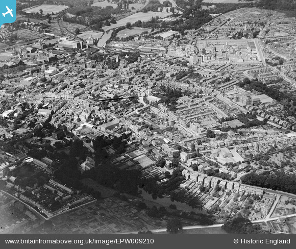
EPW009210 ENGLAND (1923). The town centre, Maidstone, 1923
© Copyright OpenStreetMap contributors and licensed by the OpenStreetMap Foundation. 2025. Cartography is licensed as CC BY-SA.
Nearby Images (5)
Details
| Title | [EPW009210] The town centre, Maidstone, 1923 |
| Reference | EPW009210 |
| Date | 1923 |
| Link | |
| Place name | MAIDSTONE |
| Parish | |
| District | |
| Country | ENGLAND |
| Easting / Northing | 576302, 155837 |
| Longitude / Latitude | 0.52783999410224, 51.273856634304 |
| National Grid Reference | TQ763558 |
Pins
 Stu Giles |
Monday 21st of May 2018 08:58:08 PM | |
 Stu Giles |
Monday 21st of May 2018 08:55:32 PM | |
 Stu Giles |
Monday 21st of May 2018 08:39:43 PM |


![[EPW009210] The town centre, Maidstone, 1923](http://britainfromabove.org.uk/sites/all/libraries/aerofilms-images/public/100x100/EPW/009/EPW009210.jpg)
![[EPW009209] Holy Trinity Church and environs, Maidstone, 1923](http://britainfromabove.org.uk/sites/all/libraries/aerofilms-images/public/100x100/EPW/009/EPW009209.jpg)
![[EPW026073] Holy Trinity Church and environs, Maidstone, 1929](http://britainfromabove.org.uk/sites/all/libraries/aerofilms-images/public/100x100/EPW/026/EPW026073.jpg)
![[EPW005629] The town centre, Maidstone, 1921. This image has been produced from a print.](http://britainfromabove.org.uk/sites/all/libraries/aerofilms-images/public/100x100/EPW/005/EPW005629.jpg)
![[EPW001456] The town, Maidstone, 1920. This image has been produced from a copy-negative.](http://britainfromabove.org.uk/sites/all/libraries/aerofilms-images/public/100x100/EPW/001/EPW001456.jpg)