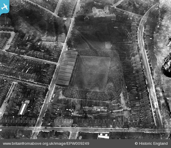
EPW009249 ENGLAND (1923). Arsenal Football Club, Highbury Ground, Highbury, 1923
© Copyright OpenStreetMap contributors and licensed by the OpenStreetMap Foundation. 2025. Cartography is licensed as CC BY-SA.
Nearby Images (13)
Details
| Title | [EPW009249] Arsenal Football Club, Highbury Ground, Highbury, 1923 |
| Reference | EPW009249 |
| Date | 1923 |
| Link | |
| Place name | HIGHBURY |
| Parish | |
| District | |
| Country | ENGLAND |
| Easting / Northing | 531624, 186011 |
| Longitude / Latitude | -0.10111314842379, 51.557128092097 |
| National Grid Reference | TQ316860 |
Pins
 Tim |
Tuesday 8th of September 2020 03:09:16 PM | |
 Merlin1993 |
Friday 25th of July 2014 10:19:02 AM | |
 billyfern |
Saturday 28th of June 2014 11:20:31 PM | |
 billyfern |
Saturday 28th of June 2014 09:05:36 PM | |
 billyfern |
Saturday 28th of June 2014 09:05:15 PM | |
 billyfern |
Saturday 28th of June 2014 09:04:38 PM | |
 billyfern |
Saturday 28th of June 2014 09:04:20 PM | |
 billyfern |
Saturday 28th of June 2014 09:04:06 PM | |
 billyfern |
Saturday 28th of June 2014 09:03:51 PM | |
 billyfern |
Saturday 28th of June 2014 09:03:25 PM | |
 billyfern |
Saturday 28th of June 2014 09:02:41 PM | |
 billyfern |
Saturday 28th of June 2014 09:02:22 PM | |
 billyfern |
Saturday 28th of June 2014 09:02:03 PM | |
 billyfern |
Saturday 28th of June 2014 09:01:43 PM | |
 billyfern |
Saturday 28th of June 2014 09:01:15 PM | |
 billyfern |
Saturday 28th of June 2014 09:00:34 PM |


![[EPW009249] Arsenal Football Club, Highbury Ground, Highbury, 1923](http://britainfromabove.org.uk/sites/all/libraries/aerofilms-images/public/100x100/EPW/009/EPW009249.jpg)
![[EPW009248] Arsenal Football Club, Highbury Ground, Highbury, 1923](http://britainfromabove.org.uk/sites/all/libraries/aerofilms-images/public/100x100/EPW/009/EPW009248.jpg)
![[EPW025837] Highbury, the FA Cup semi-final between Portsmouth and Aston Villa, 1929](http://britainfromabove.org.uk/sites/all/libraries/aerofilms-images/public/100x100/EPW/025/EPW025837.jpg)
![[EPW025838] Highbury, the FA Cup semi-final between Portsmouth and Aston Villa, 1929](http://britainfromabove.org.uk/sites/all/libraries/aerofilms-images/public/100x100/EPW/025/EPW025838.jpg)
![[EPW025836] Highbury, the FA Cup semi-final between Portsmouth and Aston Villa, 1929](http://britainfromabove.org.uk/sites/all/libraries/aerofilms-images/public/100x100/EPW/025/EPW025836.jpg)
![[EPW025835] Highbury, the FA Cup semi-final between Portsmouth and Aston Villa, 1929](http://britainfromabove.org.uk/sites/all/libraries/aerofilms-images/public/100x100/EPW/025/EPW025835.jpg)
![[EPW025834] Highbury, the FA Cup semi-final between Portsmouth and Aston Villa, 1929](http://britainfromabove.org.uk/sites/all/libraries/aerofilms-images/public/100x100/EPW/025/EPW025834.jpg)
![[EAW021413] Highbury Football Stadium (Arsenal Football Club), Highbury, 1949. This image has been produced from a print.](http://britainfromabove.org.uk/sites/all/libraries/aerofilms-images/public/100x100/EAW/021/EAW021413.jpg)
![[EPW009247] Arsenal Football Club, Highbury Ground, Highbury, 1923](http://britainfromabove.org.uk/sites/all/libraries/aerofilms-images/public/100x100/EPW/009/EPW009247.jpg)
![[EAW021414] Highbury Football Stadium (Arsenal Football Club), Highbury, 1949. This image has been produced from a print.](http://britainfromabove.org.uk/sites/all/libraries/aerofilms-images/public/100x100/EAW/021/EAW021414.jpg)
![[EAW021416] Highbury Football Stadium (Arsenal Football Club), Highbury, 1949. This image has been produced from a copy-negative.](http://britainfromabove.org.uk/sites/all/libraries/aerofilms-images/public/100x100/EAW/021/EAW021416.jpg)
![[EAW021415] Highbury Football Stadium (Arsenal Football Club), Highbury, 1949. This image has been produced from a print.](http://britainfromabove.org.uk/sites/all/libraries/aerofilms-images/public/100x100/EAW/021/EAW021415.jpg)
![[EAW021417] Highbury Football Stadium (Arsenal Football Club) and environs, Highbury, 1949. This image has been produced from a print.](http://britainfromabove.org.uk/sites/all/libraries/aerofilms-images/public/100x100/EAW/021/EAW021417.jpg)