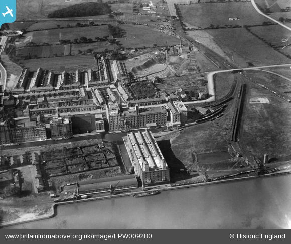
EPW009280 ENGLAND (1923). The Frost Flour Mills, Ellesmere Port, 1923
© Copyright OpenStreetMap contributors and licensed by the OpenStreetMap Foundation. 2024. Cartography is licensed as CC BY-SA.
Nearby Images (19)
Details
| Title | [EPW009280] The Frost Flour Mills, Ellesmere Port, 1923 |
| Reference | EPW009280 |
| Date | 1923 |
| Link | |
| Place name | ELLESMERE PORT |
| Parish | |
| District | |
| Country | ENGLAND |
| Easting / Northing | 340196, 377451 |
| Longitude / Latitude | -2.8972565497271, 53.290370166183 |
| National Grid Reference | SJ402775 |
Pins
 FermePark |
Saturday 7th of September 2019 02:28:15 PM |


![[EPW009280] The Frost Flour Mills, Ellesmere Port, 1923](http://britainfromabove.org.uk/sites/all/libraries/aerofilms-images/public/100x100/EPW/009/EPW009280.jpg)
![[EPW009274] The Frost Flour Mills, Ellesmere Port, 1923](http://britainfromabove.org.uk/sites/all/libraries/aerofilms-images/public/100x100/EPW/009/EPW009274.jpg)
![[EPW009279] The Frost Flour Mills, Ellesmere Port, 1923](http://britainfromabove.org.uk/sites/all/libraries/aerofilms-images/public/100x100/EPW/009/EPW009279.jpg)
![[EPW009277] The Frost Flour Mills, Ellesmere Port, 1923](http://britainfromabove.org.uk/sites/all/libraries/aerofilms-images/public/100x100/EPW/009/EPW009277.jpg)
![[EPW009275] The Frost Flour Mills, Ellesmere Port, 1923](http://britainfromabove.org.uk/sites/all/libraries/aerofilms-images/public/100x100/EPW/009/EPW009275.jpg)
![[EPW009276] The Frost Flour Mills, Ellesmere Port, 1923](http://britainfromabove.org.uk/sites/all/libraries/aerofilms-images/public/100x100/EPW/009/EPW009276.jpg)
![[EPW009278] The Frost Flour Mills, Ellesmere Port, 1923](http://britainfromabove.org.uk/sites/all/libraries/aerofilms-images/public/100x100/EPW/009/EPW009278.jpg)
![[EPW009281] The Frost Flour Mills and environs, Ellesmere Port, 1923](http://britainfromabove.org.uk/sites/all/libraries/aerofilms-images/public/100x100/EPW/009/EPW009281.jpg)
![[EAW043737] The Flour Mills on Lower Mersey Street, Ellesmere Port, 1952. This image was marked by Aerofilms Ltd for photo editing.](http://britainfromabove.org.uk/sites/all/libraries/aerofilms-images/public/100x100/EAW/043/EAW043737.jpg)
![[EAW043731] The Flour Mills on Lower Mersey Street, Ellesmere Port, 1952. This image was marked by Aerofilms Ltd for photo editing.](http://britainfromabove.org.uk/sites/all/libraries/aerofilms-images/public/100x100/EAW/043/EAW043731.jpg)
![[EAW043734] The Flour Mills on Lower Mersey Street, Ellesmere Port, 1952. This image was marked by Aerofilms Ltd for photo editing.](http://britainfromabove.org.uk/sites/all/libraries/aerofilms-images/public/100x100/EAW/043/EAW043734.jpg)
![[EAW043738] The Flour Mills on Lower Mersey Street, Ellesmere Port, 1952. This image was marked by Aerofilms Ltd for photo editing.](http://britainfromabove.org.uk/sites/all/libraries/aerofilms-images/public/100x100/EAW/043/EAW043738.jpg)
![[EAW043732] The Flour Mills on Lower Mersey Street, Ellesmere Port, 1952. This image was marked by Aerofilms Ltd for photo editing.](http://britainfromabove.org.uk/sites/all/libraries/aerofilms-images/public/100x100/EAW/043/EAW043732.jpg)
![[EAW043730] The Flour Mills on Lower Mersey Street, Ellesmere Port, 1952. This image was marked by Aerofilms Ltd for photo editing.](http://britainfromabove.org.uk/sites/all/libraries/aerofilms-images/public/100x100/EAW/043/EAW043730.jpg)
![[EAW043733] The Flour Mills on Lower Mersey Street, Ellesmere Port, 1952. This image was marked by Aerofilms Ltd for photo editing.](http://britainfromabove.org.uk/sites/all/libraries/aerofilms-images/public/100x100/EAW/043/EAW043733.jpg)
![[EPW027841] The Ellesmere Coaling Stage and Flour Mill, Ellesmere Port, 1929](http://britainfromabove.org.uk/sites/all/libraries/aerofilms-images/public/100x100/EPW/027/EPW027841.jpg)
![[EAW043735] The Flour Mills on Lower Mersey Street, Ellesmere Port, 1952. This image was marked by Aerofilms Ltd for photo editing.](http://britainfromabove.org.uk/sites/all/libraries/aerofilms-images/public/100x100/EAW/043/EAW043735.jpg)
![[EAW043736] The Flour Mills on Lower Mersey Street, Ellesmere Port, 1952. This image was marked by Aerofilms Ltd for photo editing.](http://britainfromabove.org.uk/sites/all/libraries/aerofilms-images/public/100x100/EAW/043/EAW043736.jpg)
![[EAW415732] Mount Manisty, Ellesmere Port, 1981](http://britainfromabove.org.uk/sites/all/libraries/aerofilms-images/public/100x100/EAW/415/EAW415732.jpg)