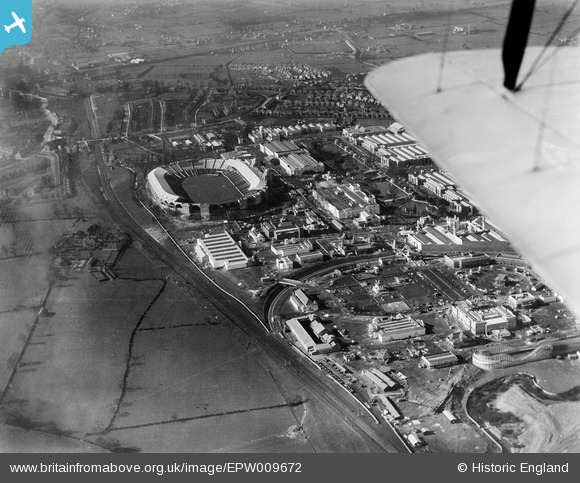
EPW009672 ENGLAND (1923). The British Empire Exhibition site, Wembley Park, 1923
© Copyright OpenStreetMap contributors and licensed by the OpenStreetMap Foundation. 2025. Cartography is licensed as CC BY-SA.
Nearby Images (46)
Details
| Title | [EPW009672] The British Empire Exhibition site, Wembley Park, 1923 |
| Reference | EPW009672 |
| Date | 1923 |
| Link | |
| Place name | WEMBLEY PARK |
| Parish | |
| District | |
| Country | ENGLAND |
| Easting / Northing | 519636, 185591 |
| Longitude / Latitude | -0.27411348104094, 51.55602349541 |
| National Grid Reference | TQ196856 |
Pins
Be the first to add a comment to this image!
User Comment Contributions
 James Crawford |
Tuesday 30th of July 2013 11:49:14 AM |


![[EPW009672] The British Empire Exhibition site, Wembley Park, 1923](http://britainfromabove.org.uk/sites/all/libraries/aerofilms-images/public/100x100/EPW/009/EPW009672.jpg)
![[EPW009651] Pavilions of the British Empire Exhibition under construction, Wembley Park, 1923](http://britainfromabove.org.uk/sites/all/libraries/aerofilms-images/public/100x100/EPW/009/EPW009651.jpg)
![[EPW009653] Pavilions of the British Empire Exhibition under construction, Wembley Park, 1923](http://britainfromabove.org.uk/sites/all/libraries/aerofilms-images/public/100x100/EPW/009/EPW009653.jpg)
![[EPW010845] The British Empire Exhibition, Wembley Park, 1924](http://britainfromabove.org.uk/sites/all/libraries/aerofilms-images/public/100x100/EPW/010/EPW010845.jpg)
![[EPW010844] The British Empire Exhibition, Wembley Park, 1924](http://britainfromabove.org.uk/sites/all/libraries/aerofilms-images/public/100x100/EPW/010/EPW010844.jpg)
![[EPW010737] The British Empire Exhibition, Wembley Park, 1924](http://britainfromabove.org.uk/sites/all/libraries/aerofilms-images/public/100x100/EPW/010/EPW010737.jpg)
![[EPW010846] The British Empire Exhibition, Wembley Park, 1924](http://britainfromabove.org.uk/sites/all/libraries/aerofilms-images/public/100x100/EPW/010/EPW010846.jpg)
![[EPW009671] Pavilions of the British Empire Exhibition under construction, Wembley Park, 1923](http://britainfromabove.org.uk/sites/all/libraries/aerofilms-images/public/100x100/EPW/009/EPW009671.jpg)
![[EPW010847] The British Empire Exhibition, Wembley Park, 1924](http://britainfromabove.org.uk/sites/all/libraries/aerofilms-images/public/100x100/EPW/010/EPW010847.jpg)
![[EPW009544] Adams Bridge and pavilions of the British Empire Exhibition under construction, Wembley Park, 1923](http://britainfromabove.org.uk/sites/all/libraries/aerofilms-images/public/100x100/EPW/009/EPW009544.jpg)
![[EPW009670] The British Empire Exhibition site, Wembley Park, 1923](http://britainfromabove.org.uk/sites/all/libraries/aerofilms-images/public/100x100/EPW/009/EPW009670.jpg)
![[EPW017631] Wembley Park, The FA Cup Final between Cardiff City and Arsenal, 1927](http://britainfromabove.org.uk/sites/all/libraries/aerofilms-images/public/100x100/EPW/017/EPW017631.jpg)
![[EPW022716] Wembley Stadium, Wembley Park, 1928. This image has been produced from a copy-negative.](http://britainfromabove.org.uk/sites/all/libraries/aerofilms-images/public/100x100/EPW/022/EPW022716.jpg)
![[EPW035050] Wembley Park, Wembley Stadium and environs before the start of the Cup Final between West Bromwich Albion and Birmingham, 1931](http://britainfromabove.org.uk/sites/all/libraries/aerofilms-images/public/100x100/EPW/035/EPW035050.jpg)
![[EPW040770] The north-east corner of Wembley Stadium and the Palace of Industry, Wembley Park, 1932. This image has been produced from a damaged negative.](http://britainfromabove.org.uk/sites/all/libraries/aerofilms-images/public/100x100/EPW/040/EPW040770.jpg)
![[EPW011413] Wembley Park, Boxing Match between Tommy Gibbons and Jack Bloomfield, 1924](http://britainfromabove.org.uk/sites/all/libraries/aerofilms-images/public/100x100/EPW/011/EPW011413.jpg)
![[EPW009546] The Canada and Australia Pavilions of the British Empire Exhibition under construction, Wembley Park, 1923](http://britainfromabove.org.uk/sites/all/libraries/aerofilms-images/public/100x100/EPW/009/EPW009546.jpg)
![[EPW009669] The India Pavilion of the British Empire Exhibition, Wembley Park, 1923](http://britainfromabove.org.uk/sites/all/libraries/aerofilms-images/public/100x100/EPW/009/EPW009669.jpg)
![[EPW010726] The British Empire Exhibition, Wembley Park, 1924. This image has been produced from a copy-negative.](http://britainfromabove.org.uk/sites/all/libraries/aerofilms-images/public/100x100/EPW/010/EPW010726.jpg)
![[EPW008279] The British Empire Exhibition Stadium (Wembley Stadium) and site under construction, Wembley Park, 1923. This image has been produced from a copy-negative.](http://britainfromabove.org.uk/sites/all/libraries/aerofilms-images/public/100x100/EPW/008/EPW008279.jpg)
![[EPW017629] Wembley Park, The FA Cup Final between Cardiff City and Arsenal, 1927](http://britainfromabove.org.uk/sites/all/libraries/aerofilms-images/public/100x100/EPW/017/EPW017629.jpg)
![[EPW026436] Wembley, FA Cup Final between Bolton Wanderers and Portsmouth, 1929](http://britainfromabove.org.uk/sites/all/libraries/aerofilms-images/public/100x100/EPW/026/EPW026436.jpg)
![[EAW048874] Wembley Stadium, Wembley Park, 1953](http://britainfromabove.org.uk/sites/all/libraries/aerofilms-images/public/100x100/EAW/048/EAW048874.jpg)
![[EPW011411] Wembley Park, Boxing Match between Tommy Gibbons and Jack Bloomfield, 1924](http://britainfromabove.org.uk/sites/all/libraries/aerofilms-images/public/100x100/EPW/011/EPW011411.jpg)
![[EPW010843] The British Empire Exhibition, Wembley Park, 1924](http://britainfromabove.org.uk/sites/all/libraries/aerofilms-images/public/100x100/EPW/010/EPW010843.jpg)
![[EPW020869] Wembley Park, The FA Cup Final between Blackburn Rovers and Huddersfield Town, 1928](http://britainfromabove.org.uk/sites/all/libraries/aerofilms-images/public/100x100/EPW/020/EPW020869.jpg)
![[EPW011385] Wembley Park, the British Empire Exhibition, 1924. This image has been produced from a copy-negative.](http://britainfromabove.org.uk/sites/all/libraries/aerofilms-images/public/100x100/EPW/011/EPW011385.jpg)
![[EPW015322] Wembley Park, the FA Cup Final between Bolton Wanderers and Manchester City, 1926](http://britainfromabove.org.uk/sites/all/libraries/aerofilms-images/public/100x100/EPW/015/EPW015322.jpg)
![[EPW017634] Wembley Park, The FA Cup Final between Cardiff City and Arsenal, 1927](http://britainfromabove.org.uk/sites/all/libraries/aerofilms-images/public/100x100/EPW/017/EPW017634.jpg)
![[EPW017628] Wembley Park, The FA Cup Final between Cardiff City and Arsenal, 1927](http://britainfromabove.org.uk/sites/all/libraries/aerofilms-images/public/100x100/EPW/017/EPW017628.jpg)
![[EPW017633] Wembley Park, The FA Cup Final between Cardiff City and Arsenal, 1927](http://britainfromabove.org.uk/sites/all/libraries/aerofilms-images/public/100x100/EPW/017/EPW017633.jpg)
![[EPW031457] Wembley Stadium, Wembley Park, 1930](http://britainfromabove.org.uk/sites/all/libraries/aerofilms-images/public/100x100/EPW/031/EPW031457.jpg)
![[EPW009543] The India Pavilion of the British Empire Exhibition under construction, Wembley Park, 1923](http://britainfromabove.org.uk/sites/all/libraries/aerofilms-images/public/100x100/EPW/009/EPW009543.jpg)
![[EPW010454] Wembley Park, Empire Day Celebrations in the Empire Stadium, 1924](http://britainfromabove.org.uk/sites/all/libraries/aerofilms-images/public/100x100/EPW/010/EPW010454.jpg)
![[EPW012731] Wembley Park, the FA Cup Final between Sheffield United and Cardiff City, 1925](http://britainfromabove.org.uk/sites/all/libraries/aerofilms-images/public/100x100/EPW/012/EPW012731.jpg)
![[EPW017637] Wembley Park, The FA Cup Final between Cardiff City and Arsenal, 1927](http://britainfromabove.org.uk/sites/all/libraries/aerofilms-images/public/100x100/EPW/017/EPW017637.jpg)
![[EPW020866] Wembley Park, The FA Cup Final between Blackburn Rovers and Huddersfield Town, 1928](http://britainfromabove.org.uk/sites/all/libraries/aerofilms-images/public/100x100/EPW/020/EPW020866.jpg)
![[EPW025121] Wembley Stadium railway station and environs, Wembley Park, 1928](http://britainfromabove.org.uk/sites/all/libraries/aerofilms-images/public/100x100/EPW/025/EPW025121.jpg)
![[EPW010736] The British Empire Exhibition, Wembley Park, 1924](http://britainfromabove.org.uk/sites/all/libraries/aerofilms-images/public/100x100/EPW/010/EPW010736.jpg)
![[EPW020861] The Empire Stadium and car parking for FA Cup Final Day, Wembley Park, from the north, 1928](http://britainfromabove.org.uk/sites/all/libraries/aerofilms-images/public/100x100/EPW/020/EPW020861.jpg)
![[EPW020342] The Empire Stadium, Wembley, 1928](http://britainfromabove.org.uk/sites/all/libraries/aerofilms-images/public/100x100/EPW/020/EPW020342.jpg)
![[EPW017627] Wembley Park, The FA Cup Final between Cardiff City and Arsenal, 1927](http://britainfromabove.org.uk/sites/all/libraries/aerofilms-images/public/100x100/EPW/017/EPW017627.jpg)
![[EPW046911] Wembley Park, the FA Cup Final between Sheffield Wednesday and West Bromwich Albion, 1935](http://britainfromabove.org.uk/sites/all/libraries/aerofilms-images/public/100x100/EPW/046/EPW046911.jpg)
![[EPW022717] Wembley Stadium, Wembley Park, 1928](http://britainfromabove.org.uk/sites/all/libraries/aerofilms-images/public/100x100/EPW/022/EPW022717.jpg)
![[EPW010842] The British Empire Exhibition, Wembley Park, 1924](http://britainfromabove.org.uk/sites/all/libraries/aerofilms-images/public/100x100/EPW/010/EPW010842.jpg)
