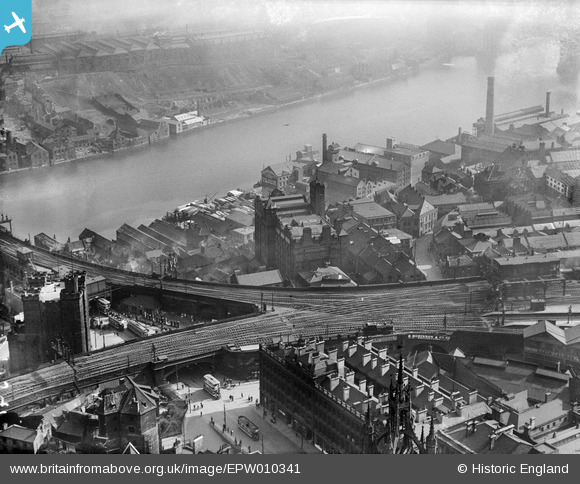
EPW010341 ENGLAND (1924). R. Robinson and Company Works (Turnball Warehouse) and environs, Newcastle upon Tyne, 1924
© Copyright OpenStreetMap contributors and licensed by the OpenStreetMap Foundation. 2024. Cartography is licensed as CC BY-SA.
Nearby Images (20)
Details
| Title | [EPW010341] R. Robinson and Company Works (Turnball Warehouse) and environs, Newcastle upon Tyne, 1924 |
| Reference | EPW010341 |
| Date | April-1924 |
| Link | |
| Place name | NEWCASTLE UPON TYNE |
| Parish | |
| District | |
| Country | ENGLAND |
| Easting / Northing | 424969, 563818 |
| Longitude / Latitude | -1.6099363210222, 54.968282133477 |
| National Grid Reference | NZ250638 |
Pins
 John Wass |
Tuesday 15th of July 2014 08:23:39 PM | |
 John Wass |
Tuesday 15th of July 2014 08:21:53 PM |


![[EPW010341] R. Robinson and Company Works (Turnball Warehouse) and environs, Newcastle upon Tyne, 1924](http://britainfromabove.org.uk/sites/all/libraries/aerofilms-images/public/100x100/EPW/010/EPW010341.jpg)
![[EPW010342] The High Level Bridge and environs, Newcastle upon Tyne, 1924](http://britainfromabove.org.uk/sites/all/libraries/aerofilms-images/public/100x100/EPW/010/EPW010342.jpg)
![[EPW010344] R. Robinsons and Company Works (Turnball Warehouse), Newcastle upon Tyne, 1924](http://britainfromabove.org.uk/sites/all/libraries/aerofilms-images/public/100x100/EPW/010/EPW010344.jpg)
![[EPW010392] R. Robinsons Company and view over the city, Newcastle upon Tyne, 1924](http://britainfromabove.org.uk/sites/all/libraries/aerofilms-images/public/100x100/EPW/010/EPW010392.jpg)
![[EPW010345] R. Robinsons and Company Works (Turnball Warehouse), Newcastle upon Tyne, 1924](http://britainfromabove.org.uk/sites/all/libraries/aerofilms-images/public/100x100/EPW/010/EPW010345.jpg)
![[EPW009980] R. Robinson and Co Works (Turnballs Warehouse), Newcastle upon Tyne, 1924](http://britainfromabove.org.uk/sites/all/libraries/aerofilms-images/public/100x100/EPW/009/EPW009980.jpg)
![[EPW010395] R. Robinsons and Company Works (Turnball Warehouse) and the surrounding city, Newcastle upon Tyne, 1924. This image has been produced from a print.](http://britainfromabove.org.uk/sites/all/libraries/aerofilms-images/public/100x100/EPW/010/EPW010395.jpg)
![[EPW010343] R. Robinsons and Company Works (Turnball Warehouse) and environs, Newcastle upon Tyne, 1924. This image has been produced from a print.](http://britainfromabove.org.uk/sites/all/libraries/aerofilms-images/public/100x100/EPW/010/EPW010343.jpg)
![[EPW010411] The High Level and Swing Bridges and view over the city, Newcastle upon Tyne, 1924](http://britainfromabove.org.uk/sites/all/libraries/aerofilms-images/public/100x100/EPW/010/EPW010411.jpg)
![[EPW009979] The Spillers and Bakers Mill and Wharf, Newcastle upon Tyne, 1924](http://britainfromabove.org.uk/sites/all/libraries/aerofilms-images/public/100x100/EPW/009/EPW009979.jpg)
![[EPW048800] The High Level Bridge, Newcastle Swing Bridge and Tyne Bridge, Newcastle Upon Tyne, 1935. This image has been produced from a copy-negative.](http://britainfromabove.org.uk/sites/all/libraries/aerofilms-images/public/100x100/EPW/048/EPW048800.jpg)
![[EPW010393] The High Level Bridge and Newcastle Swing Bridge, Newcastle upon Tyne, 1924. This image has been produced from a print.](http://britainfromabove.org.uk/sites/all/libraries/aerofilms-images/public/100x100/EPW/010/EPW010393.jpg)
![[EPW009976] The Spillers and Bakers Mill and Wharf, Newcastle upon Tyne, 1924](http://britainfromabove.org.uk/sites/all/libraries/aerofilms-images/public/100x100/EPW/009/EPW009976.jpg)
![[EPW009975] The Spillers and Bakers Mill and Wharf, Newcastle upon Tyne, 1924](http://britainfromabove.org.uk/sites/all/libraries/aerofilms-images/public/100x100/EPW/009/EPW009975.jpg)
![[EPW009978] The Spillers and Bakers Mill and Wharf, Newcastle upon Tyne, 1924](http://britainfromabove.org.uk/sites/all/libraries/aerofilms-images/public/100x100/EPW/009/EPW009978.jpg)
![[EPW019825] St Nicholas' Cathedral and environs, Newcastle upon Tyne, 1927. This image has been produced from a copy-negative.](http://britainfromabove.org.uk/sites/all/libraries/aerofilms-images/public/100x100/EPW/019/EPW019825.jpg)
![[EPW009977] The Spillers and Bakers Mill and Wharf, Newcastle upon Tyne, 1924](http://britainfromabove.org.uk/sites/all/libraries/aerofilms-images/public/100x100/EPW/009/EPW009977.jpg)
![[EAW405203] Bridges over the River Tyne, Newcastle upon Tyne, from the north-east, 1981](http://britainfromabove.org.uk/sites/all/libraries/aerofilms-images/public/100x100/EAW/405/EAW405203.jpg)
![[EAW017459] Carliol Square, Grey Street and Pilgrim Street, Newcastle upon Tyne, 1948. This image has been produced from a print.](http://britainfromabove.org.uk/sites/all/libraries/aerofilms-images/public/100x100/EAW/017/EAW017459.jpg)
![[EPW010391] St John the Baptist's Church, Grainger Street and environs, Newcastle upon Tyne, 1924](http://britainfromabove.org.uk/sites/all/libraries/aerofilms-images/public/100x100/EPW/010/EPW010391.jpg)