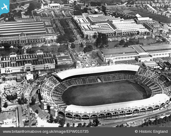
EPW010735 ENGLAND (1924). The British Empire Exhibition, Wembley Park, 1924
© Copyright OpenStreetMap contributors and licensed by the OpenStreetMap Foundation. 2025. Cartography is licensed as CC BY-SA.
Nearby Images (48)
Details
| Title | [EPW010735] The British Empire Exhibition, Wembley Park, 1924 |
| Reference | EPW010735 |
| Date | June-1924 |
| Link | |
| Place name | WEMBLEY PARK |
| Parish | |
| District | |
| Country | ENGLAND |
| Easting / Northing | 519354, 185647 |
| Longitude / Latitude | -0.27816066383169, 51.55658659091 |
| National Grid Reference | TQ194856 |
Pins
Be the first to add a comment to this image!
User Comment Contributions
Image reversed left-right? Canada and CNR pavilions should be to East of Princes Path - the central avenue just North of the Stadium |
 CH |
Tuesday 3rd of June 2014 08:25:20 PM |


![[EPW008076] The British Empire Exhibition Stadium (Wembley Stadium) under construction, Wembley Park, from the north-west, 1922. This image has been produced from a copy-negative.](http://britainfromabove.org.uk/sites/all/libraries/aerofilms-images/public/100x100/EPW/008/EPW008076.jpg)
![[EAW048879] Wembley Stadium and the Palace of Industry, Wembley Park, 1953](http://britainfromabove.org.uk/sites/all/libraries/aerofilms-images/public/100x100/EAW/048/EAW048879.jpg)
![[EPW012752] The British Empire Exhibition, Wembley Park, 1925](http://britainfromabove.org.uk/sites/all/libraries/aerofilms-images/public/100x100/EPW/012/EPW012752.jpg)
![[EPW017623] Wembley Park and Stadium, Wembley, 1927](http://britainfromabove.org.uk/sites/all/libraries/aerofilms-images/public/100x100/EPW/017/EPW017623.jpg)
![[EPW017635] Wembley Park, The FA Cup Final between Cardiff City and Arsenal, 1927](http://britainfromabove.org.uk/sites/all/libraries/aerofilms-images/public/100x100/EPW/017/EPW017635.jpg)
![[EAW038566] Wembley Park, the Speedway semi-final of the London Cup (Wembley vs New Cross) at Wembley Stadium, 1951. This image has been produced from a print.](http://britainfromabove.org.uk/sites/all/libraries/aerofilms-images/public/100x100/EAW/038/EAW038566.jpg)
![[EPW009602] The British Empire Exhibition site, Wembley Park, 1923](http://britainfromabove.org.uk/sites/all/libraries/aerofilms-images/public/100x100/EPW/009/EPW009602.jpg)
![[EPW046905] Wembley Park, the FA Cup Final between Sheffield Wednesday and West Bromwich Albion, 1935](http://britainfromabove.org.uk/sites/all/libraries/aerofilms-images/public/100x100/EPW/046/EPW046905.jpg)
![[EAW048878] Wembley Stadium, Wembley Park, 1953](http://britainfromabove.org.uk/sites/all/libraries/aerofilms-images/public/100x100/EAW/048/EAW048878.jpg)
![[EPW046907] Wembley Park, the FA Cup Final between Sheffield Wednesday and West Bromwich Albion, 1935](http://britainfromabove.org.uk/sites/all/libraries/aerofilms-images/public/100x100/EPW/046/EPW046907.jpg)
![[EAW017618] Wembley Park, crowds gathering at the Empire Stadium for the opening ceremony of the 1948 London Olympics, 1948. This image has been produced from a print.](http://britainfromabove.org.uk/sites/all/libraries/aerofilms-images/public/100x100/EAW/017/EAW017618.jpg)
![[EAW017619] Wembley Park, crowds gathering at the Empire Stadium for the opening ceremony of the 1948 London Olympics, 1948. This image has been produced from a print.](http://britainfromabove.org.uk/sites/all/libraries/aerofilms-images/public/100x100/EAW/017/EAW017619.jpg)
![[EAW018313] The Empire Stadium, Wembley Park, 1948. This image has been produced from a print.](http://britainfromabove.org.uk/sites/all/libraries/aerofilms-images/public/100x100/EAW/018/EAW018313.jpg)
![[EPW017636] Wembley Park, The FA Cup Final between Cardiff City and Arsenal, 1927](http://britainfromabove.org.uk/sites/all/libraries/aerofilms-images/public/100x100/EPW/017/EPW017636.jpg)
![[EPW026431] Wembley, FA Cup Final between Bolton Wanderers and Portsmouth, 1929](http://britainfromabove.org.uk/sites/all/libraries/aerofilms-images/public/100x100/EPW/026/EPW026431.jpg)
![[EPW020862] Wembley Park, The FA Cup Final between Blackburn Rovers and Huddersfield Town, 1928](http://britainfromabove.org.uk/sites/all/libraries/aerofilms-images/public/100x100/EPW/020/EPW020862.jpg)
![[EPW026433] Wembley, FA Cup Final between Bolton Wanderers and Portsmouth, 1929](http://britainfromabove.org.uk/sites/all/libraries/aerofilms-images/public/100x100/EPW/026/EPW026433.jpg)
![[EPW009655] The Empire Stadium, Wembley Park, 1923](http://britainfromabove.org.uk/sites/all/libraries/aerofilms-images/public/100x100/EPW/009/EPW009655.jpg)
![[EPW010456] Wembley Park, Empire Day Celebrations in the Empire Stadium, 1924](http://britainfromabove.org.uk/sites/all/libraries/aerofilms-images/public/100x100/EPW/010/EPW010456.jpg)
![[EPW026438] Wembley, FA Cup Final between Bolton Wanderers and Portsmouth, 1929](http://britainfromabove.org.uk/sites/all/libraries/aerofilms-images/public/100x100/EPW/026/EPW026438.jpg)
![[EPW010462] Wembley Park, Empire Day Celebrations in the Empire Stadium, 1924](http://britainfromabove.org.uk/sites/all/libraries/aerofilms-images/public/100x100/EPW/010/EPW010462.jpg)
![[EPW045706] The Empire Swimming Pool and Sports Arena, Wembley Stadium and environs, Wembley Park, 1934. This image has been produced from a damaged negative.](http://britainfromabove.org.uk/sites/all/libraries/aerofilms-images/public/100x100/EPW/045/EPW045706.jpg)
![[EPW034581] The Empire Stadium, Wembley Park, 1930](http://britainfromabove.org.uk/sites/all/libraries/aerofilms-images/public/100x100/EPW/034/EPW034581.jpg)
![[EAW018311] The Empire Stadium, Wembley Park, 1948. This image has been produced from a print.](http://britainfromabove.org.uk/sites/all/libraries/aerofilms-images/public/100x100/EAW/018/EAW018311.jpg)
![[EPW046239] The Empire Swimming Pool and Sports Arena and Wembley Stadium, Wembley Park, 1934](http://britainfromabove.org.uk/sites/all/libraries/aerofilms-images/public/100x100/EPW/046/EPW046239.jpg)
![[EPW046913] Wembley Park, the FA Cup Final between Sheffield Wednesday and West Bromwich Albion, 1935](http://britainfromabove.org.uk/sites/all/libraries/aerofilms-images/public/100x100/EPW/046/EPW046913.jpg)
![[EPW010461] Wembley Park, Empire Day Celebrations in the Empire Stadium, 1924](http://britainfromabove.org.uk/sites/all/libraries/aerofilms-images/public/100x100/EPW/010/EPW010461.jpg)
![[EPW010459] Wembley Park, Empire Day Celebrations in the Empire Stadium, 1924](http://britainfromabove.org.uk/sites/all/libraries/aerofilms-images/public/100x100/EPW/010/EPW010459.jpg)
![[EAW014141] The Empire (Wembley) Stadium, Wembley Park, 1948. This image has been produced from a damaged negative.](http://britainfromabove.org.uk/sites/all/libraries/aerofilms-images/public/100x100/EAW/014/EAW014141.jpg)
![[EPW017625] Wembley Park and Stadium, Wembley, 1927](http://britainfromabove.org.uk/sites/all/libraries/aerofilms-images/public/100x100/EPW/017/EPW017625.jpg)
![[EAW018312] The Empire Stadium, Wembley Park, 1948. This image has been produced from a print.](http://britainfromabove.org.uk/sites/all/libraries/aerofilms-images/public/100x100/EAW/018/EAW018312.jpg)
![[EPW046910] Wembley Park, the FA Cup Final between Sheffield Wednesday and West Bromwich Albion, from the west, 1935](http://britainfromabove.org.uk/sites/all/libraries/aerofilms-images/public/100x100/EPW/046/EPW046910.jpg)
![[EPW010458] Wembley Park, Empire Day Celebrations in the Empire Stadium, 1924](http://britainfromabove.org.uk/sites/all/libraries/aerofilms-images/public/100x100/EPW/010/EPW010458.jpg)
![[EPW017624] Wembley Park and Stadium, Wembley, 1927](http://britainfromabove.org.uk/sites/all/libraries/aerofilms-images/public/100x100/EPW/017/EPW017624.jpg)
![[EPW010457] Wembley Park, Empire Day Celebrations in the Empire Stadium, 1924](http://britainfromabove.org.uk/sites/all/libraries/aerofilms-images/public/100x100/EPW/010/EPW010457.jpg)
![[EPW010460] Wembley Park, Empire Day Celebrations in the Empire Stadium, 1924](http://britainfromabove.org.uk/sites/all/libraries/aerofilms-images/public/100x100/EPW/010/EPW010460.jpg)
![[EAW038567] Wembley Park, the Speedway semi-final of the London Cup (Wembley vs New Cross) at Wembley Stadium, 1951. This image has been produced from a print.](http://britainfromabove.org.uk/sites/all/libraries/aerofilms-images/public/100x100/EAW/038/EAW038567.jpg)
![[EPW045943] The Empire Pool and Sports Arena, Wembley Park, 1934](http://britainfromabove.org.uk/sites/all/libraries/aerofilms-images/public/100x100/EPW/045/EPW045943.jpg)
![[EPW046914] Wembley Park, car parking at the FA Cup Final between Sheffield Wednesday and West Bromwich Albion, from the west, 1935](http://britainfromabove.org.uk/sites/all/libraries/aerofilms-images/public/100x100/EPW/046/EPW046914.jpg)
![[EPW046906] Wembley Park, car parking at the FA Cup Final between Sheffield Wednesday and West Bromwich Albion, from the north-west, 1935](http://britainfromabove.org.uk/sites/all/libraries/aerofilms-images/public/100x100/EPW/046/EPW046906.jpg)
![[EPW045944] The Empire Pool and Sports Arena, Wembley Park, 1934](http://britainfromabove.org.uk/sites/all/libraries/aerofilms-images/public/100x100/EPW/045/EPW045944.jpg)
![[EPW035048] Wembley Park, Wembley Park before the start of the Cup Final between West Bromwich Albion and Birmingham, 1931. This image has been produced from a damaged negative.](http://britainfromabove.org.uk/sites/all/libraries/aerofilms-images/public/100x100/EPW/035/EPW035048.jpg)
![[EAW018318] The Empire Pool, Wembley Park, 1948. This image has been produced from a print.](http://britainfromabove.org.uk/sites/all/libraries/aerofilms-images/public/100x100/EAW/018/EAW018318.jpg)
![[EAW018317] The Empire Pool, Wembley Park, 1948. This image has been produced from a print.](http://britainfromabove.org.uk/sites/all/libraries/aerofilms-images/public/100x100/EAW/018/EAW018317.jpg)
![[EPW045703] The Empire Swimming Pool and Sports Arena, Wembley Park, 1934](http://britainfromabove.org.uk/sites/all/libraries/aerofilms-images/public/100x100/EPW/045/EPW045703.jpg)
![[EAW018319] The Empire Pool, Wembley Park, 1948. This image has been produced from a print.](http://britainfromabove.org.uk/sites/all/libraries/aerofilms-images/public/100x100/EAW/018/EAW018319.jpg)
![[EPW009652] The British Empire Exhibition site, Wembley Park, from the south-west, 1923](http://britainfromabove.org.uk/sites/all/libraries/aerofilms-images/public/100x100/EPW/009/EPW009652.jpg)
![[EPW009547] The Palace of Industries and pavilions of the British Empire Exhibition under construction, Wembley Park, 1923](http://britainfromabove.org.uk/sites/all/libraries/aerofilms-images/public/100x100/EPW/009/EPW009547.jpg)