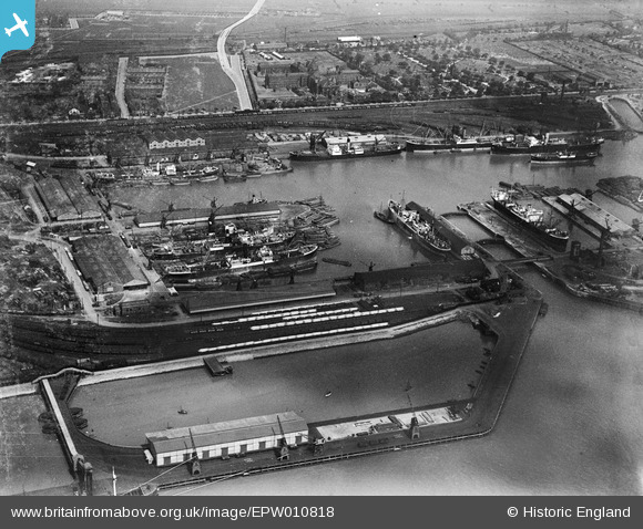
EPW010818 ENGLAND (1924). Alexandra Dock, Kingston upon Hull, 1924
© Copyright OpenStreetMap contributors and licensed by the OpenStreetMap Foundation. 2025. Cartography is licensed as CC BY-SA.
Nearby Images (12)
Details
| Title | [EPW010818] Alexandra Dock, Kingston upon Hull, 1924 |
| Reference | EPW010818 |
| Date | June-1924 |
| Link | |
| Place name | KINGSTON UPON HULL |
| Parish | |
| District | |
| Country | ENGLAND |
| Easting / Northing | 512257, 428851 |
| Longitude / Latitude | -0.29764650615839, 53.743711621109 |
| National Grid Reference | TA123289 |
Pins
 John Wass |
Saturday 1st of August 2015 09:39:35 PM | |
 John Wass |
Monday 10th of November 2014 11:54:23 AM | |
 John Wass |
Monday 10th of November 2014 11:53:52 AM |


![[EPW010818] Alexandra Dock, Kingston upon Hull, 1924](http://britainfromabove.org.uk/sites/all/libraries/aerofilms-images/public/100x100/EPW/010/EPW010818.jpg)
![[EPW036555] Alexandra Dock, Kingston upon Hull, 1931](http://britainfromabove.org.uk/sites/all/libraries/aerofilms-images/public/100x100/EPW/036/EPW036555.jpg)
![[EPW036427] Alexandra Dock and environs, Kingston upon Hull, from the south-west, 1931](http://britainfromabove.org.uk/sites/all/libraries/aerofilms-images/public/100x100/EPW/036/EPW036427.jpg)
![[EAW324975] Alexandra Dock, Kingston upon Hull, 1976](http://britainfromabove.org.uk/sites/all/libraries/aerofilms-images/public/100x100/EAW/324/EAW324975.jpg)
![[EAW004505] Alexandra Dock and environs, Kingston upon Hull, from the west, 1947](http://britainfromabove.org.uk/sites/all/libraries/aerofilms-images/public/100x100/EAW/004/EAW004505.jpg)
![[EPW036392] Boats moored in Alexandra Dock and environs, Kingston upon Hull, from the south-west, 1931](http://britainfromabove.org.uk/sites/all/libraries/aerofilms-images/public/100x100/EPW/036/EPW036392.jpg)
![[EAW046142] West Wharf, Alexandra Dock and the city, Kingston upon Hull, from the south-east, 1952](http://britainfromabove.org.uk/sites/all/libraries/aerofilms-images/public/100x100/EAW/046/EAW046142.jpg)
![[EPW036527] Alexandra Dock, West Wharf and the city, Kingston upon Hull, from the south-east, 1931](http://britainfromabove.org.uk/sites/all/libraries/aerofilms-images/public/100x100/EPW/036/EPW036527.jpg)
![[EPW010808] Alexandra Dock, Kingston upon Hull, from the south-west, 1924](http://britainfromabove.org.uk/sites/all/libraries/aerofilms-images/public/100x100/EPW/010/EPW010808.jpg)
![[EAW046139] Alexandra Dock, Kingston upon Hull, from the north-west, 1952](http://britainfromabove.org.uk/sites/all/libraries/aerofilms-images/public/100x100/EAW/046/EAW046139.jpg)
![[EAW015661] West Wharf and the Southcoates area, Marfleet, from the south, 1948. This image has been produced from a print.](http://britainfromabove.org.uk/sites/all/libraries/aerofilms-images/public/100x100/EAW/015/EAW015661.jpg)
![[EPW036554] West Wharf and Alexandra Dock, Kingston upon Hull, 1931](http://britainfromabove.org.uk/sites/all/libraries/aerofilms-images/public/100x100/EPW/036/EPW036554.jpg)