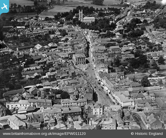
EPW011120 ENGLAND (1924). The High Street, Andover, 1924
© Copyright OpenStreetMap contributors and licensed by the OpenStreetMap Foundation. 2024. Cartography is licensed as CC BY-SA.
Nearby Images (14)
Details
| Title | [EPW011120] The High Street, Andover, 1924 |
| Reference | EPW011120 |
| Date | July-1924 |
| Link | |
| Place name | ANDOVER |
| Parish | ANDOVER |
| District | |
| Country | ENGLAND |
| Easting / Northing | 436474, 145517 |
| Longitude / Latitude | -1.4778219097758, 51.207178125693 |
| National Grid Reference | SU365455 |
Pins
 David960 |
Tuesday 3rd of February 2015 11:44:01 PM |


![[EPW011120] The High Street, Andover, 1924](http://britainfromabove.org.uk/sites/all/libraries/aerofilms-images/public/100x100/EPW/011/EPW011120.jpg)
![[EPW011122] The High Street, Andover, 1924](http://britainfromabove.org.uk/sites/all/libraries/aerofilms-images/public/100x100/EPW/011/EPW011122.jpg)
![[EPW011123] The Town Hall and environs, Andover, 1924](http://britainfromabove.org.uk/sites/all/libraries/aerofilms-images/public/100x100/EPW/011/EPW011123.jpg)
![[EPW011121] The Town Hall and High Street, Andover, 1924](http://britainfromabove.org.uk/sites/all/libraries/aerofilms-images/public/100x100/EPW/011/EPW011121.jpg)
![[EPW016872] The town hall and environs, Andover, 1926](http://britainfromabove.org.uk/sites/all/libraries/aerofilms-images/public/100x100/EPW/016/EPW016872.jpg)
![[EPW011125] The High Street and environs, Andover, 1924](http://britainfromabove.org.uk/sites/all/libraries/aerofilms-images/public/100x100/EPW/011/EPW011125.jpg)
![[EPW023296] The junction of Bridge Street and the High Street, Andover, 1928](http://britainfromabove.org.uk/sites/all/libraries/aerofilms-images/public/100x100/EPW/023/EPW023296.jpg)
![[EPW023294] The High Street and the town centre, Andover, 1928](http://britainfromabove.org.uk/sites/all/libraries/aerofilms-images/public/100x100/EPW/023/EPW023294.jpg)
![[EPW022744] Road-works at the junction of High Street and London Street, Andover, 1928](http://britainfromabove.org.uk/sites/all/libraries/aerofilms-images/public/100x100/EPW/022/EPW022744.jpg)
![[EAW051916] Bridge Street and the town centre, Andover, 1953. This image was marked by Aerofilms Ltd for photo editing.](http://britainfromabove.org.uk/sites/all/libraries/aerofilms-images/public/100x100/EAW/051/EAW051916.jpg)
![[EAW051915] Bridge Street and the town centre, Andover, 1953. This image was marked by Aerofilms Ltd for photo editing.](http://britainfromabove.org.uk/sites/all/libraries/aerofilms-images/public/100x100/EAW/051/EAW051915.jpg)
![[EPW016871] The town centre, Andover, from the east, 1926](http://britainfromabove.org.uk/sites/all/libraries/aerofilms-images/public/100x100/EPW/016/EPW016871.jpg)
![[EAW051914] Bridge Street and the town centre, Andover, 1953. This image was marked by Aerofilms Ltd for photo editing.](http://britainfromabove.org.uk/sites/all/libraries/aerofilms-images/public/100x100/EAW/051/EAW051914.jpg)
![[EPW022737] Bridge Street, Andover, 1928](http://britainfromabove.org.uk/sites/all/libraries/aerofilms-images/public/100x100/EPW/022/EPW022737.jpg)