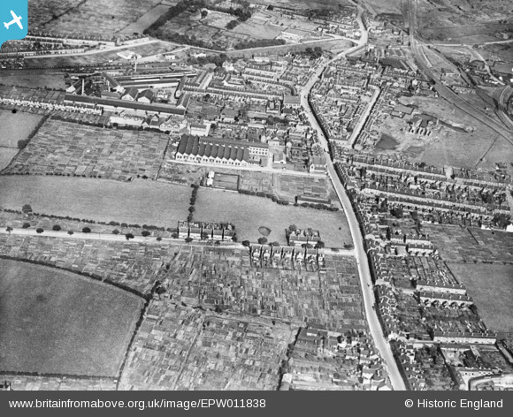
EPW011838 ENGLAND (1924). Chubb and Son's Lock and Safe Co Ltd Works off Wednesfield Road, Wolverhampton, 1924. This image has been produced from a print.
© Copyright OpenStreetMap contributors and licensed by the OpenStreetMap Foundation. 2025. Cartography is licensed as CC BY-SA.
Nearby Images (9)
Details
| Title | [EPW011838] Chubb and Son's Lock and Safe Co Ltd Works off Wednesfield Road, Wolverhampton, 1924. This image has been produced from a print. |
| Reference | EPW011838 |
| Date | September-1924 |
| Link | |
| Place name | WOLVERHAMPTON |
| Parish | |
| District | |
| Country | ENGLAND |
| Easting / Northing | 392511, 299370 |
| Longitude / Latitude | -2.1105629236354, 52.591721458798 |
| National Grid Reference | SO925994 |
Pins
 62haynes |
Thursday 4th of November 2021 03:14:39 AM | |
 GaryGareth |
Thursday 14th of September 2017 12:18:09 AM | |
 GaryGareth |
Thursday 14th of September 2017 12:16:56 AM | |
 GaryGareth |
Thursday 14th of September 2017 12:16:01 AM | |
 GaryGareth |
Thursday 14th of September 2017 12:14:39 AM | |
 Mike |
Monday 14th of September 2015 02:54:48 PM | |
 Mike |
Monday 14th of September 2015 02:54:17 PM | |
 Mike |
Monday 14th of September 2015 02:53:46 PM |


![[EPW011838] Chubb and Son's Lock and Safe Co Ltd Works off Wednesfield Road, Wolverhampton, 1924. This image has been produced from a print.](http://britainfromabove.org.uk/sites/all/libraries/aerofilms-images/public/100x100/EPW/011/EPW011838.jpg)
![[EAW048793] Chubb and Son's Lock and Safe Co Ltd Works off Wednesfield Road and environs, Heath Town, 1953. This image was marked by Aerofilms Ltd for photo editing.](http://britainfromabove.org.uk/sites/all/libraries/aerofilms-images/public/100x100/EAW/048/EAW048793.jpg)
![[EAW048794] Chubb and Son's Lock and Safe Co Ltd Works off Wednesfield Road and environs, Heath Town, 1953. This image was marked by Aerofilms Ltd for photo editing.](http://britainfromabove.org.uk/sites/all/libraries/aerofilms-images/public/100x100/EAW/048/EAW048794.jpg)
![[EAW048798] Chubb and Son's Lock and Safe Co Ltd Works, Heath Town, 1953. This image was marked by Aerofilms Ltd for photo editing.](http://britainfromabove.org.uk/sites/all/libraries/aerofilms-images/public/100x100/EAW/048/EAW048798.jpg)
![[EAW048800] Chubb and Son's Lock and Safe Co Ltd Works off Wednesfield Road and environs, Heath Town, 1953. This image was marked by Aerofilms Ltd for photo editing.](http://britainfromabove.org.uk/sites/all/libraries/aerofilms-images/public/100x100/EAW/048/EAW048800.jpg)
![[EAW048799] Chubb and Son's Lock and Safe Co Ltd Works off Wednesfield Road and environs, Heath Town, 1953. This image was marked by Aerofilms Ltd for photo editing.](http://britainfromabove.org.uk/sites/all/libraries/aerofilms-images/public/100x100/EAW/048/EAW048799.jpg)
![[EAW048795] Chubb and Son's Lock and Safe Co Ltd Works off Wednesfield Road and environs, Heath Town, 1953. This image was marked by Aerofilms Ltd for photo editing.](http://britainfromabove.org.uk/sites/all/libraries/aerofilms-images/public/100x100/EAW/048/EAW048795.jpg)
![[EAW048797] Chubb and Son's Lock and Safe Co Ltd Works off Wednesfield Road and environs, Heath Town, 1953. This image was marked by Aerofilms Ltd for photo editing.](http://britainfromabove.org.uk/sites/all/libraries/aerofilms-images/public/100x100/EAW/048/EAW048797.jpg)
![[EAW048796] Chubb and Son's Lock and Safe Co Ltd Works off Wednesfield Road and environs, Heath Town, 1953. This image was marked by Aerofilms Ltd for photo editing.](http://britainfromabove.org.uk/sites/all/libraries/aerofilms-images/public/100x100/EAW/048/EAW048796.jpg)