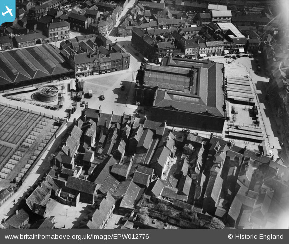
EPW012776 ENGLAND (1925). The Market Hall and Corn Exchange, Doncaster, 1925
© Copyright OpenStreetMap contributors and licensed by the OpenStreetMap Foundation. 2024. Cartography is licensed as CC BY-SA.
Nearby Images (28)
Details
| Title | [EPW012776] The Market Hall and Corn Exchange, Doncaster, 1925 |
| Reference | EPW012776 |
| Date | 15-May-1925 |
| Link | |
| Place name | DONCASTER |
| Parish | |
| District | |
| Country | ENGLAND |
| Easting / Northing | 457582, 403494 |
| Longitude / Latitude | -1.1313203776026, 53.524705669811 |
| National Grid Reference | SE576035 |
Pins
 jonron |
Saturday 5th of August 2023 02:54:13 AM | |
 Retired Railwayman |
Friday 31st of August 2012 12:06:37 AM | |
 Rob Daniels |
Thursday 19th of July 2012 12:31:43 PM | |
 Rob Daniels |
Thursday 19th of July 2012 12:30:52 PM |


![[EPW012776] The Market Hall and Corn Exchange, Doncaster, 1925](http://britainfromabove.org.uk/sites/all/libraries/aerofilms-images/public/100x100/EPW/012/EPW012776.jpg)
![[EPW061937] The Cattle Market and environs, Doncaster, 1939](http://britainfromabove.org.uk/sites/all/libraries/aerofilms-images/public/100x100/EPW/061/EPW061937.jpg)
![[EPW061935] The town centre, Doncaster, 1939](http://britainfromabove.org.uk/sites/all/libraries/aerofilms-images/public/100x100/EPW/061/EPW061935.jpg)
![[EPW061934] High Fishergate and environs, Doncaster, 1939](http://britainfromabove.org.uk/sites/all/libraries/aerofilms-images/public/100x100/EPW/061/EPW061934.jpg)
![[EPW012760] Silver Street and environs, Doncaster, 1925](http://britainfromabove.org.uk/sites/all/libraries/aerofilms-images/public/100x100/EPW/012/EPW012760.jpg)
![[EPW012775] The town centre, Doncaster, 1925](http://britainfromabove.org.uk/sites/all/libraries/aerofilms-images/public/100x100/EPW/012/EPW012775.jpg)
![[EPW012772] St George's Church, Doncaster, 1925](http://britainfromabove.org.uk/sites/all/libraries/aerofilms-images/public/100x100/EPW/012/EPW012772.jpg)
![[EAW044183] The Thomas Hanley and Sons Ltd (J. Rank Ltd) Flour Mill and St George's Church, Doncaster, 1952. This image was marked by Aerofilms Ltd for photo editing.](http://britainfromabove.org.uk/sites/all/libraries/aerofilms-images/public/100x100/EAW/044/EAW044183.jpg)
![[EPW012767] St George's Church, Doncaster, 1925. This image has been produced from a copy-negative.](http://britainfromabove.org.uk/sites/all/libraries/aerofilms-images/public/100x100/EPW/012/EPW012767.jpg)
![[EAW043791] Hanley's Flour Mills and the Cattle Market, Doncaster, 1952. This image was marked by Aerofilms Ltd for photo editing.](http://britainfromabove.org.uk/sites/all/libraries/aerofilms-images/public/100x100/EAW/043/EAW043791.jpg)
![[EAW043788] Hanley's Flour Mills, St George's Church and environs, Doncaster, 1952. This image was marked by Aerofilms Ltd for photo editing.](http://britainfromabove.org.uk/sites/all/libraries/aerofilms-images/public/100x100/EAW/043/EAW043788.jpg)
![[EPW061936] High Street and environs, Doncaster, 1939](http://britainfromabove.org.uk/sites/all/libraries/aerofilms-images/public/100x100/EPW/061/EPW061936.jpg)
![[EAW043792] Hanley's Flour Mills and St George's Church, Doncaster, 1952. This image was marked by Aerofilms Ltd for photo editing.](http://britainfromabove.org.uk/sites/all/libraries/aerofilms-images/public/100x100/EAW/043/EAW043792.jpg)
![[EAW044180] The Thomas Hanley and Sons Ltd (J. Rank Ltd) Flour Mill and environs, Doncaster, 1952. This image was marked by Aerofilms Ltd for photo editing.](http://britainfromabove.org.uk/sites/all/libraries/aerofilms-images/public/100x100/EAW/044/EAW044180.jpg)
![[EPW012756] The High Street, Doncaster, 1925](http://britainfromabove.org.uk/sites/all/libraries/aerofilms-images/public/100x100/EPW/012/EPW012756.jpg)
![[EPW012774] The junction of Baxter Gate and High Street, Doncaster, 1925](http://britainfromabove.org.uk/sites/all/libraries/aerofilms-images/public/100x100/EPW/012/EPW012774.jpg)
![[EAW043790] Hanley's Flour Mills, St George's Church and environs, Doncaster, 1952. This image was marked by Aerofilms Ltd for photo editing.](http://britainfromabove.org.uk/sites/all/libraries/aerofilms-images/public/100x100/EAW/043/EAW043790.jpg)
![[EAW044182] The Thomas Hanley and Sons Ltd (J. Rank Ltd) Flour Mill and St George's Church, Doncaster, 1952. This image was marked by Aerofilms Ltd for photo editing.](http://britainfromabove.org.uk/sites/all/libraries/aerofilms-images/public/100x100/EAW/044/EAW044182.jpg)
![[EAW044184] The Thomas Hanley and Sons Ltd (J. Rank Ltd) Flour Mill and St George's Church, Doncaster, 1952. This image was marked by Aerofilms Ltd for photo editing.](http://britainfromabove.org.uk/sites/all/libraries/aerofilms-images/public/100x100/EAW/044/EAW044184.jpg)
![[EAW043786] Hanley's Flour Mills beside the River Don New Cut, Doncaster, 1952. This image was marked by Aerofilms Ltd for photo editing.](http://britainfromabove.org.uk/sites/all/libraries/aerofilms-images/public/100x100/EAW/043/EAW043786.jpg)
![[EAW044181] The Thomas Hanley and Sons Ltd (J. Rank Ltd) Flour Mill and environs, Doncaster, 1952. This image was marked by Aerofilms Ltd for photo editing.](http://britainfromabove.org.uk/sites/all/libraries/aerofilms-images/public/100x100/EAW/044/EAW044181.jpg)
![[EAW044185] The Thomas Hanley and Sons Ltd (J. Rank Ltd) Flour Mill and environs, Doncaster, 1952. This image was marked by Aerofilms Ltd for photo editing.](http://britainfromabove.org.uk/sites/all/libraries/aerofilms-images/public/100x100/EAW/044/EAW044185.jpg)
![[EAW044186] The Thomas Hanley and Sons Ltd (J. Rank Ltd) Flour Mill, St George's Church and environs, Doncaster, 1952. This image was marked by Aerofilms Ltd for photo editing.](http://britainfromabove.org.uk/sites/all/libraries/aerofilms-images/public/100x100/EAW/044/EAW044186.jpg)
![[EAW044179] The Thomas Hanley and Sons Ltd (J. Rank Ltd) Flour Mill and St George's Church, Doncaster, 1952. This image was marked by Aerofilms Ltd for photo editing.](http://britainfromabove.org.uk/sites/all/libraries/aerofilms-images/public/100x100/EAW/044/EAW044179.jpg)
![[EPW012757] Hanley and Sons Corn Mill, Doncaster, 1925](http://britainfromabove.org.uk/sites/all/libraries/aerofilms-images/public/100x100/EPW/012/EPW012757.jpg)
![[EAW044178] The Thomas Hanley and Sons Ltd (J. Rank Ltd) Flour Mill and environs, Doncaster, 1952. This image was marked by Aerofilms Ltd for photo editing.](http://britainfromabove.org.uk/sites/all/libraries/aerofilms-images/public/100x100/EAW/044/EAW044178.jpg)
![[EAW043785] Hanley's Flour Mills beside the River Don New Cut, Doncaster, 1952. This image was marked by Aerofilms Ltd for photo editing.](http://britainfromabove.org.uk/sites/all/libraries/aerofilms-images/public/100x100/EAW/043/EAW043785.jpg)
![[EAW043787] Hanley's Flour Mills beside the River Don New Cut, Doncaster, 1952. This image was marked by Aerofilms Ltd for photo editing.](http://britainfromabove.org.uk/sites/all/libraries/aerofilms-images/public/100x100/EAW/043/EAW043787.jpg)