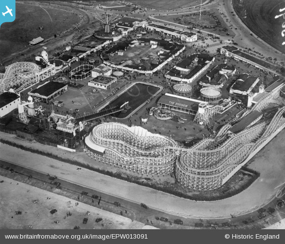
EPW013091 ENGLAND (1925). Pleasureland, Southport, 1925. This image has been produced from a copy-negative.
© Copyright OpenStreetMap contributors and licensed by the OpenStreetMap Foundation. 2025. Cartography is licensed as CC BY-SA.
Nearby Images (13)
Details
| Title | [EPW013091] Pleasureland, Southport, 1925. This image has been produced from a copy-negative. |
| Reference | EPW013091 |
| Date | June-1925 |
| Link | |
| Place name | SOUTHPORT |
| Parish | |
| District | |
| Country | ENGLAND |
| Easting / Northing | 332709, 417386 |
| Longitude / Latitude | -3.0181224081769, 53.648412119061 |
| National Grid Reference | SD327174 |
Pins
Be the first to add a comment to this image!


![[EPW013091] Pleasureland, Southport, 1925. This image has been produced from a copy-negative.](http://britainfromabove.org.uk/sites/all/libraries/aerofilms-images/public/100x100/EPW/013/EPW013091.jpg)
![[EAW038522] Pleasureland, Southport, 1951. This image has been produced from a print.](http://britainfromabove.org.uk/sites/all/libraries/aerofilms-images/public/100x100/EAW/038/EAW038522.jpg)
![[EPW020365] Pleasureland, Southport, 1928](http://britainfromabove.org.uk/sites/all/libraries/aerofilms-images/public/100x100/EPW/020/EPW020365.jpg)
![[EPW020363] Pleasureland, Southport, 1928](http://britainfromabove.org.uk/sites/all/libraries/aerofilms-images/public/100x100/EPW/020/EPW020363.jpg)
![[EPW058497] Pleasureland, Southport, 1938](http://britainfromabove.org.uk/sites/all/libraries/aerofilms-images/public/100x100/EPW/058/EPW058497.jpg)
![[EPW045243] Pleasureland and Princes Park, Southport, 1934](http://britainfromabove.org.uk/sites/all/libraries/aerofilms-images/public/100x100/EPW/045/EPW045243.jpg)
![[EPW020364] Pleasureland, Southport, 1928](http://britainfromabove.org.uk/sites/all/libraries/aerofilms-images/public/100x100/EPW/020/EPW020364.jpg)
![[EPW045244] Princes Park and the seafront, Southport, from the south-west, 1934](http://britainfromabove.org.uk/sites/all/libraries/aerofilms-images/public/100x100/EPW/045/EPW045244.jpg)
![[EPW045246] Victoria Park, Princes Park and environs, Southport, from the south-west, 1934](http://britainfromabove.org.uk/sites/all/libraries/aerofilms-images/public/100x100/EPW/045/EPW045246.jpg)
![[EAW010136] Southport, the Flower Show in Victoria Park, 1947. This image was marked by Aerofilms Ltd for photo editing.](http://britainfromabove.org.uk/sites/all/libraries/aerofilms-images/public/100x100/EAW/010/EAW010136.jpg)
![[EAW010137] Southport, the Flower Show in Victoria Park, 1947. This image was marked by Aerofilms Ltd for photo editing.](http://britainfromabove.org.uk/sites/all/libraries/aerofilms-images/public/100x100/EAW/010/EAW010137.jpg)
![[EAW038520] Pleasureland and the surrounding area, Southport, 1951. This image has been produced from a print.](http://britainfromabove.org.uk/sites/all/libraries/aerofilms-images/public/100x100/EAW/038/EAW038520.jpg)
![[EPW018657] Southport, crowds gathered for the total solar eclipse, 1927](http://britainfromabove.org.uk/sites/all/libraries/aerofilms-images/public/100x100/EPW/018/EPW018657.jpg)