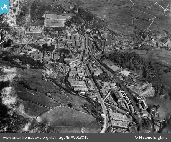
EPW013345 ENGLAND (1925). Bacup Road and environs, Waterfoot, 1925
© Copyright OpenStreetMap contributors and licensed by the OpenStreetMap Foundation. 2025. Cartography is licensed as CC BY-SA.
Details
| Title | [EPW013345] Bacup Road and environs, Waterfoot, 1925 |
| Reference | EPW013345 |
| Date | June-1925 |
| Link | |
| Place name | WATERFOOT |
| Parish | |
| District | |
| Country | ENGLAND |
| Easting / Northing | 383305, 421822 |
| Longitude / Latitude | -2.2528569574032, 53.692350037051 |
| National Grid Reference | SD833218 |
Pins
 ssShaunW1 |
Tuesday 8th of December 2020 07:52:44 PM | |
 ssShaunW1 |
Tuesday 8th of December 2020 07:52:20 PM | |
 ssShaunW1 |
Tuesday 8th of December 2020 07:47:42 PM | |
 ssShaunW1 |
Tuesday 8th of December 2020 07:45:52 PM | |
 ssShaunW1 |
Tuesday 8th of December 2020 07:45:14 PM | |
 wadey |
Monday 24th of November 2014 02:03:48 PM | |
 wadey |
Monday 24th of November 2014 02:03:20 PM | |
 wadey |
Monday 24th of November 2014 02:02:40 PM | |
 guess who |
Monday 9th of July 2012 05:23:41 PM | |
 guess who |
Monday 9th of July 2012 05:22:23 PM | |
 Damian |
Friday 6th of July 2012 04:45:56 PM |
User Comment Contributions
Yes, it is BRGS and it is missing a few more buildings that have appeared since 1925! |
 Ian |
Monday 9th of July 2012 02:36:33 PM |


![[EPW013345] Bacup Road and environs, Waterfoot, 1925](http://britainfromabove.org.uk/sites/all/libraries/aerofilms-images/public/100x100/EPW/013/EPW013345.jpg)
![[EPW013346] Bacup Road and environs, Waterfoot, 1925](http://britainfromabove.org.uk/sites/all/libraries/aerofilms-images/public/100x100/EPW/013/EPW013346.jpg)
![[EPW013347] Bacup Road, the railway line and environs, Waterfoot, 1925](http://britainfromabove.org.uk/sites/all/libraries/aerofilms-images/public/100x100/EPW/013/EPW013347.jpg)