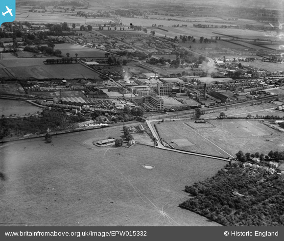
EPW015332 ENGLAND (1926). Gramophone Factories, Hayes, 1926
© Copyright OpenStreetMap contributors and licensed by the OpenStreetMap Foundation. 2025. Cartography is licensed as CC BY-SA.
Nearby Images (24)
Details
| Title | [EPW015332] Gramophone Factories, Hayes, 1926 |
| Reference | EPW015332 |
| Date | 1-June-1926 |
| Link | |
| Place name | HAYES |
| Parish | |
| District | |
| Country | ENGLAND |
| Easting / Northing | 509111, 179494 |
| Longitude / Latitude | -0.42777350315271, 51.503351618726 |
| National Grid Reference | TQ091795 |
Pins
 Class31 |
Monday 7th of October 2013 03:57:24 PM | |
 quanny33 |
Saturday 5th of January 2013 12:27:11 AM | |
at this point hunters grove is finished and minet drive is almost finished. Birchway is still a field |
 quanny33 |
Saturday 5th of January 2013 12:29:45 AM |
 southallboy |
Sunday 26th of August 2012 01:27:49 PM | |
 Mike |
Friday 27th of July 2012 08:58:47 PM | |
 Mike |
Friday 27th of July 2012 08:57:53 PM | |
 Mike |
Friday 27th of July 2012 08:56:12 PM | |
 Mike |
Friday 27th of July 2012 08:54:52 PM |


![[EPW015332] Gramophone Factories, Hayes, 1926](http://britainfromabove.org.uk/sites/all/libraries/aerofilms-images/public/100x100/EPW/015/EPW015332.jpg)
![[EPW031830] The Great Western Railway, Gramophone Company (HMV) factory buildings and environs, Hayes, 1930](http://britainfromabove.org.uk/sites/all/libraries/aerofilms-images/public/100x100/EPW/031/EPW031830.jpg)
![[EPW031827] Gramophone Company (HMV) factory buildings and environs, Hayes, 1930](http://britainfromabove.org.uk/sites/all/libraries/aerofilms-images/public/100x100/EPW/031/EPW031827.jpg)
![[EPW031839] Gramophone Company (HMV) factory buildings and environs, Hayes, 1930](http://britainfromabove.org.uk/sites/all/libraries/aerofilms-images/public/100x100/EPW/031/EPW031839.jpg)
![[EPW031822] Gramophone Company (HMV) factory buildings and environs, Hayes, from the south, 1930](http://britainfromabove.org.uk/sites/all/libraries/aerofilms-images/public/100x100/EPW/031/EPW031822.jpg)
![[EPW031826] Gramophone Company (HMV) factory buildings and environs, Hayes, 1930](http://britainfromabove.org.uk/sites/all/libraries/aerofilms-images/public/100x100/EPW/031/EPW031826.jpg)
![[EPW015335] Gramophone Factories, Hayes, 1926](http://britainfromabove.org.uk/sites/all/libraries/aerofilms-images/public/100x100/EPW/015/EPW015335.jpg)
![[EPW031823] Gramophone Company (HMV) factory buildings and environs, Hayes, 1930](http://britainfromabove.org.uk/sites/all/libraries/aerofilms-images/public/100x100/EPW/031/EPW031823.jpg)
![[EPW037590] The HMV Gramophone Factories, Hayes, 1932](http://britainfromabove.org.uk/sites/all/libraries/aerofilms-images/public/100x100/EPW/037/EPW037590.jpg)
![[EPW031832] The Great Western Railway, Gramophone Company (HMV) factory buildings and environs, Hayes, 1930](http://britainfromabove.org.uk/sites/all/libraries/aerofilms-images/public/100x100/EPW/031/EPW031832.jpg)
![[EPW031825] Gramophone Company (HMV) factory buildings and environs, Hayes, 1930](http://britainfromabove.org.uk/sites/all/libraries/aerofilms-images/public/100x100/EPW/031/EPW031825.jpg)
![[EPW031824] Gramophone Company (HMV) factory buildings and environs, Hayes, 1930](http://britainfromabove.org.uk/sites/all/libraries/aerofilms-images/public/100x100/EPW/031/EPW031824.jpg)
![[EPW015337] Gramophone Factories, Hayes, 1926](http://britainfromabove.org.uk/sites/all/libraries/aerofilms-images/public/100x100/EPW/015/EPW015337.jpg)
![[EPW008028] His Master's Voice Gramophone Works, Hayes, 1922](http://britainfromabove.org.uk/sites/all/libraries/aerofilms-images/public/100x100/EPW/008/EPW008028.jpg)
![[EPW031829] Gramophone Company (HMV) factory buildings and environs, Hayes, from the south-west, 1930](http://britainfromabove.org.uk/sites/all/libraries/aerofilms-images/public/100x100/EPW/031/EPW031829.jpg)
![[EPW015336] Gramophone Factories, Hayes, 1926](http://britainfromabove.org.uk/sites/all/libraries/aerofilms-images/public/100x100/EPW/015/EPW015336.jpg)
![[EPW008027] His Master's Voice Gramophone Works, Hayes, 1922](http://britainfromabove.org.uk/sites/all/libraries/aerofilms-images/public/100x100/EPW/008/EPW008027.jpg)
![[EPW031828] Gramophone Company (HMV) factory buildings and environs, Hayes, from the south-west, 1930](http://britainfromabove.org.uk/sites/all/libraries/aerofilms-images/public/100x100/EPW/031/EPW031828.jpg)
![[EPW031836] Gramophone Company (HMV) factory buildings and environs, Hayes, from the south-west, 1930](http://britainfromabove.org.uk/sites/all/libraries/aerofilms-images/public/100x100/EPW/031/EPW031836.jpg)
![[EPW005151] His Master's Voice Gramophone Factories, Hayes, 1920](http://britainfromabove.org.uk/sites/all/libraries/aerofilms-images/public/100x100/EPW/005/EPW005151.jpg)
![[EPW008026] His Master's Voice Gramophone Works, Hayes, 1922](http://britainfromabove.org.uk/sites/all/libraries/aerofilms-images/public/100x100/EPW/008/EPW008026.jpg)
![[EPW005150] His Master's Voice Gramophone Factories, Hayes, 1920](http://britainfromabove.org.uk/sites/all/libraries/aerofilms-images/public/100x100/EPW/005/EPW005150.jpg)
![[EPW031842] Gramophone Company (HMV) factory buildings and environs, Hayes, 1930](http://britainfromabove.org.uk/sites/all/libraries/aerofilms-images/public/100x100/EPW/031/EPW031842.jpg)
![[EPW037573] The HMV Gramophone Factories, Hayes, from the south, 1932](http://britainfromabove.org.uk/sites/all/libraries/aerofilms-images/public/100x100/EPW/037/EPW037573.jpg)