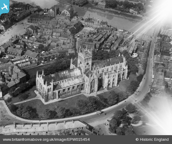
EPW015454 ENGLAND (1926). Selby Abbey, Selby, 1926
© Copyright OpenStreetMap contributors and licensed by the OpenStreetMap Foundation. 2025. Cartography is licensed as CC BY-SA.
Nearby Images (14)
Details
| Title | [EPW015454] Selby Abbey, Selby, 1926 |
| Reference | EPW015454 |
| Date | 4-May-1926 |
| Link | |
| Place name | SELBY |
| Parish | SELBY |
| District | |
| Country | ENGLAND |
| Easting / Northing | 461565, 432367 |
| Longitude / Latitude | -1.0655197199795, 53.783765773352 |
| National Grid Reference | SE616324 |
Pins
 Class31 |
Friday 26th of October 2012 11:12:06 AM | |
 Class31 |
Friday 26th of October 2012 11:11:48 AM | |
 Class31 |
Friday 26th of October 2012 11:11:33 AM | |
 Class31 |
Friday 26th of October 2012 11:11:16 AM | |
 Class31 |
Friday 26th of October 2012 11:10:59 AM | |
 Class31 |
Friday 26th of October 2012 11:10:43 AM | |
 Class31 |
Friday 26th of October 2012 11:10:25 AM | |
 Class31 |
Friday 26th of October 2012 11:10:08 AM | |
 Class31 |
Friday 26th of October 2012 11:09:52 AM |


![[EPW015454] Selby Abbey, Selby, 1926](http://britainfromabove.org.uk/sites/all/libraries/aerofilms-images/public/100x100/EPW/015/EPW015454.jpg)
![[EPW015453] Selby Abbey, Selby, 1926](http://britainfromabove.org.uk/sites/all/libraries/aerofilms-images/public/100x100/EPW/015/EPW015453.jpg)
![[EAW015504] Selby Abbey, Selby, 1948. This image has been produced from a print.](http://britainfromabove.org.uk/sites/all/libraries/aerofilms-images/public/100x100/EAW/015/EAW015504.jpg)
![[EPW015455] Selby Abbey and the Market Place, Selby, 1926](http://britainfromabove.org.uk/sites/all/libraries/aerofilms-images/public/100x100/EPW/015/EPW015455.jpg)
![[EPW040264] Selby Abbey and Selby Railway Station, Selby, 1932](http://britainfromabove.org.uk/sites/all/libraries/aerofilms-images/public/100x100/EPW/040/EPW040264.jpg)
![[EPW015448] Selby Abbey, Selby, 1926](http://britainfromabove.org.uk/sites/all/libraries/aerofilms-images/public/100x100/EPW/015/EPW015448.jpg)
![[EPW040263] Selby Abbey and the town centre, Selby, 1932](http://britainfromabove.org.uk/sites/all/libraries/aerofilms-images/public/100x100/EPW/040/EPW040263.jpg)
![[EPW015451] Selby Abbey, Selby, 1926](http://britainfromabove.org.uk/sites/all/libraries/aerofilms-images/public/100x100/EPW/015/EPW015451.jpg)
![[EAW015505] Selby Abbey and the town centre, Selby, from the north-east, 1948. This image has been produced from a print.](http://britainfromabove.org.uk/sites/all/libraries/aerofilms-images/public/100x100/EAW/015/EAW015505.jpg)
![[EAW015735] The town and River Ouse, Selby, from the west, 1948](http://britainfromabove.org.uk/sites/all/libraries/aerofilms-images/public/100x100/EAW/015/EAW015735.jpg)
![[EPW015450] Micklegate, Selby, 1926](http://britainfromabove.org.uk/sites/all/libraries/aerofilms-images/public/100x100/EPW/015/EPW015450.jpg)
![[EAW043301] Selby Abey and the town centre, Selby, 1952](http://britainfromabove.org.uk/sites/all/libraries/aerofilms-images/public/100x100/EAW/043/EAW043301.jpg)
![[EPW015452] Selby Bridge and the railway swingbridge over the River Ouse, Selby, 1926](http://britainfromabove.org.uk/sites/all/libraries/aerofilms-images/public/100x100/EPW/015/EPW015452.jpg)
![[EAW043302] The town, Selby, 1952](http://britainfromabove.org.uk/sites/all/libraries/aerofilms-images/public/100x100/EAW/043/EAW043302.jpg)