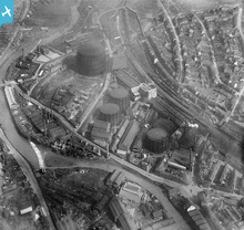
EPW015598 ENGLAND (1926). The Neepsend Gas Works, Sheffield, 1926
© Copyright OpenStreetMap contributors and licensed by the OpenStreetMap Foundation. 2025. Cartography is licensed as CC BY-SA.
Nearby Images (14)
Details
| Title | [EPW015598] The Neepsend Gas Works, Sheffield, 1926 |
| Reference | EPW015598 |
| Date | 4-May-1926 |
| Link | |
| Place name | SHEFFIELD |
| Parish | |
| District | |
| Country | ENGLAND |
| Easting / Northing | 434577, 388843 |
| Longitude / Latitude | -1.4799636176158, 53.395023236828 |
| National Grid Reference | SK346888 |
Pins
 Mick.. |
Monday 7th of June 2021 11:31:48 PM | |
 neddy |
Wednesday 29th of October 2014 12:36:48 PM | |
 Brooky |
Sunday 24th of November 2013 07:58:03 PM | |
 Brooky |
Sunday 24th of November 2013 07:54:21 PM | |
 Brooky |
Sunday 24th of November 2013 07:40:27 PM | |
 Class31 |
Friday 26th of October 2012 04:13:45 PM | |
 Class31 |
Friday 26th of October 2012 04:13:20 PM | |
 Class31 |
Friday 26th of October 2012 04:12:52 PM | |
 Class31 |
Friday 26th of October 2012 04:12:33 PM | |
 Class31 |
Friday 26th of October 2012 04:12:05 PM | |
 Class31 |
Friday 26th of October 2012 04:11:39 PM | |
 Class31 |
Friday 26th of October 2012 04:11:24 PM | |
 Class31 |
Friday 26th of October 2012 04:11:00 PM | |
 Class31 |
Friday 26th of October 2012 04:10:31 PM | |
 Class31 |
Friday 26th of October 2012 04:09:58 PM | |
Packhorse or Steelbank Weir |
 DCRT Karen |
Thursday 4th of August 2016 10:06:56 AM |
 Class31 |
Friday 26th of October 2012 04:09:39 PM |
User Comment Contributions
I was born at 27 Parkwood Road shown on this photo and lived there till 1934.My grandparents lived at no.15 and aunt at no 32.On the 13th Dec.1940 in the Sheffield Blitz, all the even nos were totally gutted by fire bombs dropped to light up the target followed by a landmine on No 15 which wiped out half the street leaving the last half to be pulled down later. The good news is that in 2009 an action committee was formed to develop the whole of Parkwood as a country park as big as the city centre just a mile or two away. Ron Spencer |
 balbus |
Monday 13th of January 2014 07:59:51 PM |
 MM |
Thursday 21st of March 2013 10:31:26 AM |


![[EPW015598] The Neepsend Gas Works, Sheffield, 1926](http://britainfromabove.org.uk/sites/all/libraries/aerofilms-images/public/100x100/EPW/015/EPW015598.jpg)
![[EPW015494] The Neepsend Gas Works, Sheffield, 1926](http://britainfromabove.org.uk/sites/all/libraries/aerofilms-images/public/100x100/EPW/015/EPW015494.jpg)
![[EPW015488] The Neepsend Gas Works, Sheffield, 1926](http://britainfromabove.org.uk/sites/all/libraries/aerofilms-images/public/100x100/EPW/015/EPW015488.jpg)
![[EPW015484] The Neepsend Gas Works, Sheffield, 1926](http://britainfromabove.org.uk/sites/all/libraries/aerofilms-images/public/100x100/EPW/015/EPW015484.jpg)
![[EPW015493] The Neepsend Gas Works, Sheffield, 1926](http://britainfromabove.org.uk/sites/all/libraries/aerofilms-images/public/100x100/EPW/015/EPW015493.jpg)
![[EPW015597] The Neepsend Gas Works, Sheffield, 1926](http://britainfromabove.org.uk/sites/all/libraries/aerofilms-images/public/100x100/EPW/015/EPW015597.jpg)
![[EPW015486] The Neepsend Gas Works, Sheffield, 1926](http://britainfromabove.org.uk/sites/all/libraries/aerofilms-images/public/100x100/EPW/015/EPW015486.jpg)
![[EAW005032] The Hallamshire Steel and File Works alongside the Neepsend Gas Works, Sheffield, 1947](http://britainfromabove.org.uk/sites/all/libraries/aerofilms-images/public/100x100/EAW/005/EAW005032.jpg)
![[EAW005029] The Hallamshire Steel and File Works alongside the Neepsend Gas Works, Sheffield, 1947](http://britainfromabove.org.uk/sites/all/libraries/aerofilms-images/public/100x100/EAW/005/EAW005029.jpg)
![[EAW005028] The Hallamshire Steel and File Works alongside the Neepsend Gas Works, Sheffield, 1947](http://britainfromabove.org.uk/sites/all/libraries/aerofilms-images/public/100x100/EAW/005/EAW005028.jpg)
![[EAW005031] The Hallamshire Steel and File Works alongside the Neepsend Gas Works, Sheffield, 1947](http://britainfromabove.org.uk/sites/all/libraries/aerofilms-images/public/100x100/EAW/005/EAW005031.jpg)
![[EAW005030] The Hallamshire Steel and File Works, Sheffield, 1947](http://britainfromabove.org.uk/sites/all/libraries/aerofilms-images/public/100x100/EAW/005/EAW005030.jpg)
![[EPW057400] Pensitone Road and environs, Sheffield, 1938. This image has been produced from a print.](http://britainfromabove.org.uk/sites/all/libraries/aerofilms-images/public/100x100/EPW/057/EPW057400.jpg)
![[EAW005033] The Hallamshire Steel and File Works, Sheffield, 1947](http://britainfromabove.org.uk/sites/all/libraries/aerofilms-images/public/100x100/EAW/005/EAW005033.jpg)
