
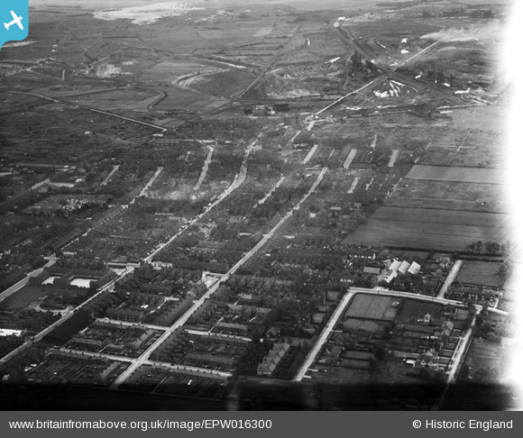
EPW016300 ENGLAND (1926). Frodingham, Scunthorpe, from the south-west, 1926
© Copyright OpenStreetMap contributors and licensed by the OpenStreetMap Foundation. 2024. Cartography is licensed as CC BY-SA.
Nearby Images (2)
EPW016300

EPW012778

Details
| Title | [EPW016300] Frodingham, Scunthorpe, from the south-west, 1926 |
| Reference | EPW016300 |
| Date | 14-July-1926 |
| Link | |
| Place name | SCUNTHORPE |
| Parish | |
| District | |
| Country | ENGLAND |
| Easting / Northing | 489107, 411191 |
| Longitude / Latitude | -0.6536594288301, 53.589477732684 |
| National Grid Reference | SE891112 |
Pins
 Ray Jones |
Tuesday 15th of October 2024 11:41:34 PM | |
Ray Jones |
Tuesday 15th of October 2024 11:40:31 PM | |
Ray Jones |
Tuesday 15th of October 2024 11:38:23 PM | |
Ray Jones |
Tuesday 15th of October 2024 11:37:25 PM | |
Hamst |
Saturday 6th of June 2020 04:54:50 PM | |
DaveH |
Thursday 21st of November 2019 05:12:47 PM | |
DaveH |
Thursday 21st of November 2019 05:06:21 PM | |
DaveH |
Thursday 21st of November 2019 05:01:47 PM | |
DaveH |
Thursday 21st of November 2019 05:01:17 PM | |
angus |
Sunday 30th of June 2013 04:48:52 PM | |
angus |
Sunday 30th of June 2013 04:47:40 PM | |
flyover |
Tuesday 22nd of January 2013 11:07:41 PM | |
Felix |
Sunday 21st of October 2012 03:08:24 PM | |
nickd48 |
Thursday 26th of July 2012 10:18:36 PM | |
nickd48 |
Thursday 26th of July 2012 10:17:50 PM |