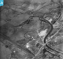
EPW016447 ENGLAND (1926). The River Irk passing under the Rochdale Canal and the railway line, Chadderton, 1926
© Copyright OpenStreetMap contributors and licensed by the OpenStreetMap Foundation. 2025. Cartography is licensed as CC BY-SA.
Details
| Title | [EPW016447] The River Irk passing under the Rochdale Canal and the railway line, Chadderton, 1926 |
| Reference | EPW016447 |
| Date | 6-August-1926 |
| Link | |
| Place name | CHADDERTON |
| Parish | |
| District | |
| Country | ENGLAND |
| Easting / Northing | 389002, 406336 |
| Longitude / Latitude | -2.1660253810598, 53.553293740312 |
| National Grid Reference | SD890063 |
Pins
 keith |
Friday 22nd of May 2015 03:43:18 PM | |
 Alan Tinker |
Friday 6th of March 2015 08:15:44 AM | |
 Mike Taylor |
Thursday 24th of July 2014 12:05:42 PM | |
 Allan |
Friday 8th of November 2013 10:49:17 PM | |
The Duke of Bridgewater pub must have been a private residence after the pub closed. I knew a lad who lived there - we must have both been about 13 in 1960-61 and he drowned in the canal close to the house. I don't remember his name. |
 Mike T. |
Monday 25th of July 2016 12:18:23 AM |
 Geoff Wellens |
Friday 19th of October 2012 07:22:03 PM | |
 Geoff Wellens |
Friday 19th of October 2012 07:18:44 PM | |
 eddief |
Monday 17th of September 2012 03:26:53 PM | |
 eddief |
Monday 17th of September 2012 03:25:43 PM | |
 eddief |
Monday 17th of September 2012 03:25:01 PM | |
 eddief |
Monday 17th of September 2012 03:23:28 PM | |
 Geoff Wellens |
Friday 3rd of August 2012 06:34:43 PM | |
Another great photo Geoff-thanks for posting. |
 Cabby |
Tuesday 29th of July 2014 06:58:26 AM |
 Geoff Wellens |
Friday 3rd of August 2012 06:27:19 PM | |
This is an incident I had never heard of before Geoff. many thanks for this information and a great photo. |
 Cabby |
Tuesday 29th of July 2014 06:55:56 AM |
 Al Roach |
Monday 16th of July 2012 10:56:29 AM | |
 Al Roach |
Monday 16th of July 2012 10:55:49 AM | |
 Al Roach |
Monday 16th of July 2012 10:54:36 AM | |
 Al Roach |
Monday 16th of July 2012 10:50:11 AM | |
 Al Roach |
Monday 16th of July 2012 10:41:59 AM | |
 Al Roach |
Monday 16th of July 2012 10:40:46 AM |
User Comment Contributions
This is the point where the canal burst in 1927 and flooded Middleton town centre with the loss of 3 lives. The repair was poorly done since the same area failed just after the canal was reopened in 2002 resulting in a repair that cost a lot of money. This is also the point where the 1793 line was planned to continue northwards in more or less a straight line up the hill. The line with the sharp bend to the west was the original line of 1791 and was in the end the one used. |
 Frank S |
Sunday 3rd of March 2013 03:02:32 PM |


