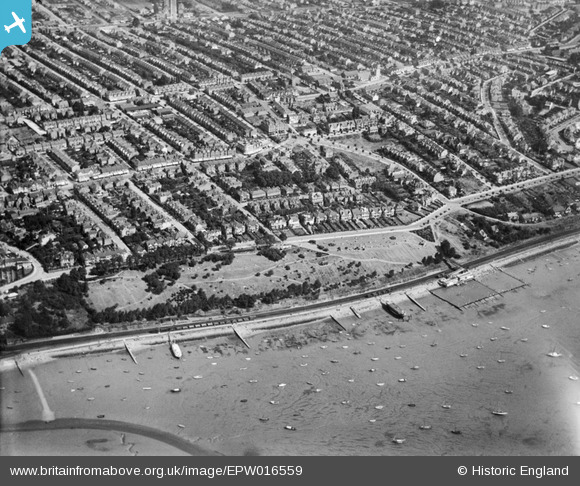
EPW016559 ENGLAND (1926). Leigh Cliffs and surrounding housing, Leigh-on-Sea, 1926
© Copyright OpenStreetMap contributors and licensed by the OpenStreetMap Foundation. 2025. Cartography is licensed as CC BY-SA.
Nearby Images (11)
Details
| Title | [EPW016559] Leigh Cliffs and surrounding housing, Leigh-on-Sea, 1926 |
| Reference | EPW016559 |
| Date | 26-August-1926 |
| Link | |
| Place name | LEIGH-ON-SEA |
| Parish | LEIGH-ON-SEA |
| District | |
| Country | ENGLAND |
| Easting / Northing | 584483, 185694 |
| Longitude / Latitude | 0.66053818650876, 51.539472232566 |
| National Grid Reference | TQ845857 |


![[EPW016559] Leigh Cliffs and surrounding housing, Leigh-on-Sea, 1926](http://britainfromabove.org.uk/sites/all/libraries/aerofilms-images/public/100x100/EPW/016/EPW016559.jpg)
![[EAW053098] Cliff Parade and Avenue Road, Leigh-on-Sea, 1954](http://britainfromabove.org.uk/sites/all/libraries/aerofilms-images/public/100x100/EAW/053/EAW053098.jpg)
![[EPW037011] Leigh Gardens and environs, Leigh-on-Sea, 1931](http://britainfromabove.org.uk/sites/all/libraries/aerofilms-images/public/100x100/EPW/037/EPW037011.jpg)
![[EPW058503] Cliff Parade and environs, Leigh-on-Sea, 1938. This image was marked by Aerofilms Ltd for photo editing.](http://britainfromabove.org.uk/sites/all/libraries/aerofilms-images/public/100x100/EPW/058/EPW058503.jpg)
![[EAW024657] Leigh Cliffs and the town, Leigh-on-Sea, from the south, 1949](http://britainfromabove.org.uk/sites/all/libraries/aerofilms-images/public/100x100/EAW/024/EAW024657.jpg)
![[EAW024656] The town and waterfront, Leigh-on-Sea, from the south-east, 1949](http://britainfromabove.org.uk/sites/all/libraries/aerofilms-images/public/100x100/EAW/024/EAW024656.jpg)
![[EPW036708] Leigh Cliffs Recreation Ground and the town, Leigh-on-Sea, from the south, 1931](http://britainfromabove.org.uk/sites/all/libraries/aerofilms-images/public/100x100/EPW/036/EPW036708.jpg)
![[EPW037012] Leigh Gardens and environs, Leigh-on-Sea, from the south, 1931](http://britainfromabove.org.uk/sites/all/libraries/aerofilms-images/public/100x100/EPW/037/EPW037012.jpg)
![[EPW036737] The Leigh Cliffs Recreation Ground, St Clement's Church and environs, Leigh-on-Sea, 1931](http://britainfromabove.org.uk/sites/all/libraries/aerofilms-images/public/100x100/EPW/036/EPW036737.jpg)
![[EPW037014] The Bathing Pool, Cliff Parade and environs, Leigh-on-Sea, from the south, 1931](http://britainfromabove.org.uk/sites/all/libraries/aerofilms-images/public/100x100/EPW/037/EPW037014.jpg)
![[EPW040972] The Leigh Cliffs outdoor Bathing Pool, Cliff Parade and the town, Leigh-on-Sea, from the south-east, 1933](http://britainfromabove.org.uk/sites/all/libraries/aerofilms-images/public/100x100/EPW/040/EPW040972.jpg)
