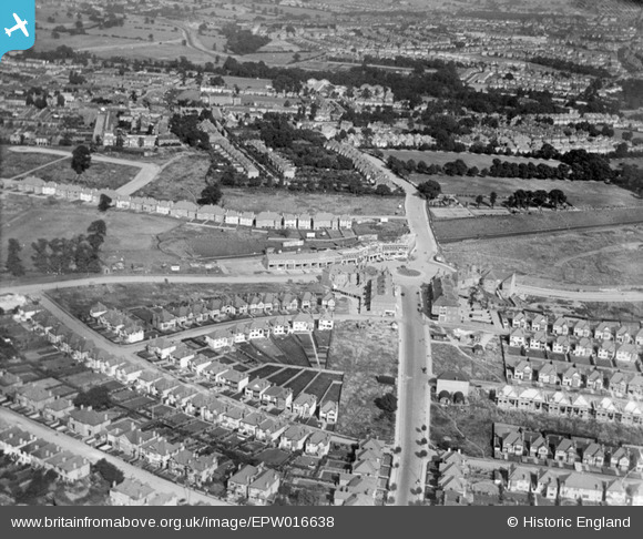
EPW016638 ENGLAND (1926). Central Circus and environs, Hendon, 1926
© Copyright OpenStreetMap contributors and licensed by the OpenStreetMap Foundation. 2024. Cartography is licensed as CC BY-SA.
Nearby Images (15)
Details
| Title | [EPW016638] Central Circus and environs, Hendon, 1926 |
| Reference | EPW016638 |
| Date | August-1926 |
| Link | |
| Place name | HENDON |
| Parish | |
| District | |
| Country | ENGLAND |
| Easting / Northing | 522915, 188665 |
| Longitude / Latitude | -0.22575868979813, 51.582947814416 |
| National Grid Reference | TQ229887 |
Pins
 Class31 |
Sunday 23rd of September 2012 10:26:02 PM | |
 NthLondonBoy |
Wednesday 29th of August 2012 03:52:28 PM | |
 Jim Rea |
Monday 27th of August 2012 02:58:45 PM | |
 JC |
Saturday 21st of July 2012 12:36:21 AM | |
 JC |
Saturday 21st of July 2012 12:34:09 AM | |
 JC |
Saturday 21st of July 2012 12:32:37 AM | |
 JC |
Saturday 21st of July 2012 12:31:35 AM | |
 JC |
Saturday 21st of July 2012 12:31:10 AM | |
This was known as Butchers Lane, which ran from Brent Street to The Burrough's, Hendon. Butcher's Lane was renamed to honour Queen Victoria around the same time that Queen's Park (now Hendon Park was opened c 1903) |
 Jim Rea |
Monday 27th of August 2012 02:55:50 PM |
 JC |
Saturday 21st of July 2012 12:30:36 AM |


![[EPW016638] Central Circus and environs, Hendon, 1926](http://britainfromabove.org.uk/sites/all/libraries/aerofilms-images/public/100x100/EPW/016/EPW016638.jpg)
![[EPW031656] Central Circus and Queen's Road, Hendon, from the west, 1930](http://britainfromabove.org.uk/sites/all/libraries/aerofilms-images/public/100x100/EPW/031/EPW031656.jpg)
![[EPW016523] Central Circus and environs, Hendon, 1926](http://britainfromabove.org.uk/sites/all/libraries/aerofilms-images/public/100x100/EPW/016/EPW016523.jpg)
![[EPW016521] Central Circus and environs, Hendon, 1926](http://britainfromabove.org.uk/sites/all/libraries/aerofilms-images/public/100x100/EPW/016/EPW016521.jpg)
![[EPW008746] Construction of Hendon Central Station and the Central Circus, Hendon, 1923. This image has been produced from a copy-negative.](http://britainfromabove.org.uk/sites/all/libraries/aerofilms-images/public/100x100/EPW/008/EPW008746.jpg)
![[EPW031659] Central Circus, Hendon, 1930](http://britainfromabove.org.uk/sites/all/libraries/aerofilms-images/public/100x100/EPW/031/EPW031659.jpg)
![[EPW038717] Hendon Central Station and the Central Circus, Hendon, 1932](http://britainfromabove.org.uk/sites/all/libraries/aerofilms-images/public/100x100/EPW/038/EPW038717.jpg)
![[EPW009348] The Central Circus under construction, Hendon, 1923. This image has been produced from a print.](http://britainfromabove.org.uk/sites/all/libraries/aerofilms-images/public/100x100/EPW/009/EPW009348.jpg)
![[EPW031652] Hendon Central Railway Station and Central Circus, Hendon, 1930](http://britainfromabove.org.uk/sites/all/libraries/aerofilms-images/public/100x100/EPW/031/EPW031652.jpg)
![[EPW016520] Central Circus and environs, Hendon, 1926](http://britainfromabove.org.uk/sites/all/libraries/aerofilms-images/public/100x100/EPW/016/EPW016520.jpg)
![[EPW009537] The Central Circus under construction, Hendon, 1923. This image has been produced from a copy-negative.](http://britainfromabove.org.uk/sites/all/libraries/aerofilms-images/public/100x100/EPW/009/EPW009537.jpg)
![[EPR000516] Central Circus, Hendon, 1935](http://britainfromabove.org.uk/sites/all/libraries/aerofilms-images/public/100x100/EPR/000/EPR000516.jpg)
![[EPW040430] Housing development around Hendon Central, Hendon, from the south, 1932](http://britainfromabove.org.uk/sites/all/libraries/aerofilms-images/public/100x100/EPW/040/EPW040430.jpg)
![[EPW031654] Watford Way and Central Circus, Hendon, from the north, 1930](http://britainfromabove.org.uk/sites/all/libraries/aerofilms-images/public/100x100/EPW/031/EPW031654.jpg)
![[EPW016522] Central Circus and Vivian Avenue, Hendon, 1926](http://britainfromabove.org.uk/sites/all/libraries/aerofilms-images/public/100x100/EPW/016/EPW016522.jpg)