
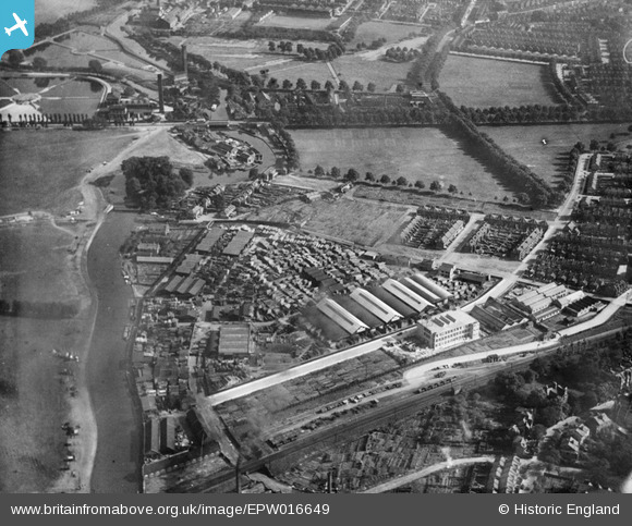
EPW016649 ENGLAND (1926). Leaside Wharf Timber Mills, Lea Bridge, 1926
© Copyright OpenStreetMap contributors and licensed by the OpenStreetMap Foundation. 2025. Cartography is licensed as CC BY-SA.
Nearby Images (2)
EPW016649

EPW016650

Details
| Title | [EPW016649] Leaside Wharf Timber Mills, Lea Bridge, 1926 |
| Reference | EPW016649 |
| Date | August-1926 |
| Link | |
| Place name | LEA BRIDGE |
| Parish | |
| District | |
| Country | ENGLAND |
| Easting / Northing | 535267, 186835 |
| Longitude / Latitude | -0.048272316439329, 51.563671590303 |
| National Grid Reference | TQ353868 |
Pins
 Dank |
Wednesday 1st of January 2020 04:13:52 PM | |
Chris Hevey |
Monday 20th of January 2014 11:56:21 AM | |
Chris Hevey |
Monday 20th of January 2014 11:55:48 AM | |
Chris Hevey |
Monday 20th of January 2014 11:54:33 AM | |
Chris Hevey |
Monday 20th of January 2014 11:53:36 AM | |
Chris Hevey |
Monday 20th of January 2014 11:51:35 AM | |
Chris Hevey |
Monday 20th of January 2014 11:50:29 AM | |
Chris Hevey |
Monday 20th of January 2014 11:46:11 AM | |
Chris Hevey |
Monday 20th of January 2014 11:46:10 AM | |
 8-2007.JPG) Keith |
Friday 13th of July 2012 11:20:25 PM | |
This pin is on the site of the ice rink. The basketball area was to the north. And while the actions of the local authority and Olympic committee were lazy, other options were available, the land used was very low grade open space, as you say on bomb damage landfill, not a pristine marsh was often publicised. Sadly it was replaced with more of the same a year or so later. |
hackneyglyn |
Thursday 31st of December 2015 10:04:32 AM |
Keith |
Friday 13th of July 2012 11:14:30 PM | |
Keith |
Friday 13th of July 2012 11:13:41 PM | |
Keith |
Friday 13th of July 2012 11:10:15 PM | |
Millfields Road. |
gBr |
Monday 6th of March 2017 09:42:41 PM |