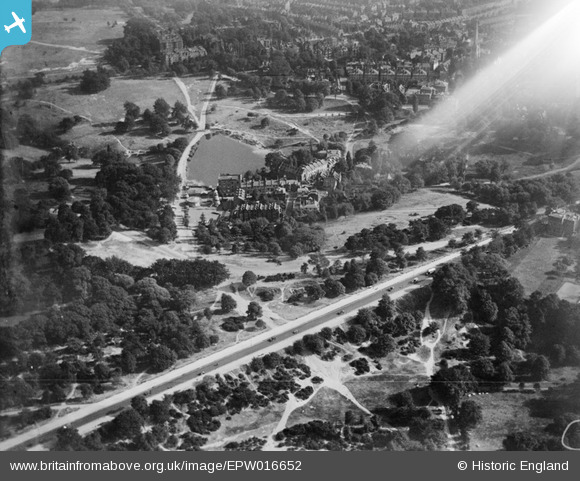
EPW016652 ENGLAND (1926). The Hampstead Pond and the Vale of Health, Hampstead Heath, 1926
© Copyright OpenStreetMap contributors and licensed by the OpenStreetMap Foundation. 2025. Cartography is licensed as CC BY-SA.
Nearby Images (15)
Details
| Title | [EPW016652] The Hampstead Pond and the Vale of Health, Hampstead Heath, 1926 |
| Reference | EPW016652 |
| Date | August-1926 |
| Link | |
| Place name | HAMPSTEAD HEATH |
| Parish | |
| District | |
| Country | ENGLAND |
| Easting / Northing | 526474, 186525 |
| Longitude / Latitude | -0.17518381948491, 51.562926267652 |
| National Grid Reference | TQ265865 |


![[EPW016652] The Hampstead Pond and the Vale of Health, Hampstead Heath, 1926](http://britainfromabove.org.uk/sites/all/libraries/aerofilms-images/public/100x100/EPW/016/EPW016652.jpg)
![[EPW056652] Vale of Health, Hampstead, 1938](http://britainfromabove.org.uk/sites/all/libraries/aerofilms-images/public/100x100/EPW/056/EPW056652.jpg)
![[EPW000815] Spaniards Road, Vale of Heath, Hampstead, 1920](http://britainfromabove.org.uk/sites/all/libraries/aerofilms-images/public/100x100/EPW/000/EPW000815.jpg)
![[EAW000612] Vale of Health, Hampstead Ponds and Hampstead Heath, Hampstead, 1946](http://britainfromabove.org.uk/sites/all/libraries/aerofilms-images/public/100x100/EAW/000/EAW000612.jpg)
![[EPW009353] Whitestone pond and environs, Hampstead, 1923](http://britainfromabove.org.uk/sites/all/libraries/aerofilms-images/public/100x100/EPW/009/EPW009353.jpg)
![[EPW000430] Whitestone Pond, Hampstead, from the north, 1920](http://britainfromabove.org.uk/sites/all/libraries/aerofilms-images/public/100x100/EPW/000/EPW000430.jpg)
![[EPW026948] Spaniard's Road and funfair on Hampstead Heath, Hampstead, 1929](http://britainfromabove.org.uk/sites/all/libraries/aerofilms-images/public/100x100/EPW/026/EPW026948.jpg)
![[EPW013228] Vale of Health and East Heath, Hampstead Heath, 1925. This image has been produced from a copy-negative.](http://britainfromabove.org.uk/sites/all/libraries/aerofilms-images/public/100x100/EPW/013/EPW013228.jpg)
![[EPW005126] Spaniards Road, Hampstead, 1920](http://britainfromabove.org.uk/sites/all/libraries/aerofilms-images/public/100x100/EPW/005/EPW005126.jpg)
![[EPW028171] Spaniard's Road and Whitestone Pond, Hampstead Heath, from the north, 1929](http://britainfromabove.org.uk/sites/all/libraries/aerofilms-images/public/100x100/EPW/028/EPW028171.jpg)
![[EPW000818] Whitestone Pond, Hampstead, 1920](http://britainfromabove.org.uk/sites/all/libraries/aerofilms-images/public/100x100/EPW/000/EPW000818.jpg)
![[EPW005118] Spaniards Road and environs, Hampstead Heath, 1920](http://britainfromabove.org.uk/sites/all/libraries/aerofilms-images/public/100x100/EPW/005/EPW005118.jpg)
![[EPW028170] Whitestone Pond, Hampstead Heath, 1929](http://britainfromabove.org.uk/sites/all/libraries/aerofilms-images/public/100x100/EPW/028/EPW028170.jpg)
![[EPW056655] Whitestone Pond and environs, Hampstead Heath, 1938](http://britainfromabove.org.uk/sites/all/libraries/aerofilms-images/public/100x100/EPW/056/EPW056655.jpg)
![[EPW026949] Whitestone Pond and environs, Hampstead Heath, 1929. This image has been produce from a damaged print.](http://britainfromabove.org.uk/sites/all/libraries/aerofilms-images/public/100x100/EPW/026/EPW026949.jpg)

