
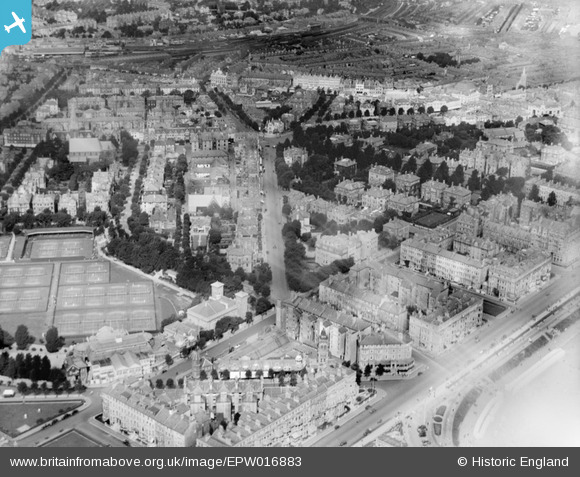
EPW016883 ENGLAND (1926). Cornfield Terrace and Chiswick Place, Eastbourne, 1926
© Copyright OpenStreetMap contributors and licensed by the OpenStreetMap Foundation. 2025. Cartography is licensed as CC BY-SA.
Nearby Images (8)
EPW016883

EAW006141

EAW022969

EAW006140

EAW006143

EAW006139

EAW022971

EAW006142

Details
| Title | [EPW016883] Cornfield Terrace and Chiswick Place, Eastbourne, 1926 |
| Reference | EPW016883 |
| Date | August-1926 |
| Link | |
| Place name | EASTBOURNE |
| Parish | |
| District | |
| Country | ENGLAND |
| Easting / Northing | 561275, 98604 |
| Longitude / Latitude | 0.2871195920553, 50.764013356568 |
| National Grid Reference | TV613986 |
Pins
 E J Moore |
Monday 26th of April 2021 03:59:05 PM | |
Mikeo1938 |
Tuesday 11th of December 2012 08:07:41 PM | |
Mikeo1938 |
Tuesday 11th of December 2012 08:02:56 PM | |
Mikeo1938 |
Tuesday 11th of December 2012 08:00:29 PM | |
Mikeo1938 |
Tuesday 11th of December 2012 07:55:00 PM |
User Comment Contributions
The imposing white building in the distance with the dome and columns was the original Barclays Bank (probably Lewes Old Bank in 1926), at the corner of Terminus Road and Junction Road. How clearly it stands out from the air – and no wonder it was singled out (and destroyed) by the pilot of a German fighter-bomber on 7 March 1943. The first turning on the left from the seafront is Carlisle Road - note the tower of the Devonshire Baths and the glass roof of the two swimming baths. Via Google Street View, one can see where the ornamental turret used to be above the first shop on the right - what it pity it was removed! |
Mikeo1938 |
Tuesday 26th of June 2012 08:41:39 PM |