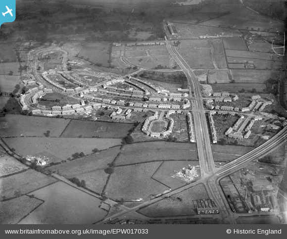
EPW017033 ENGLAND (1926). The Pype Hayes and Tyburn Road area, Tyburn, 1926
© Copyright OpenStreetMap contributors and licensed by the OpenStreetMap Foundation. 2025. Cartography is licensed as CC BY-SA.
Nearby Images (3)
EPW017033

EPW017035

EPW017034

Details
| Title | [EPW017033] The Pype Hayes and Tyburn Road area, Tyburn, 1926 |
| Reference | EPW017033 |
| Date | 6-October-1926 |
| Link | |
| Place name | TYBURN |
| Parish | |
| District | |
| Country | ENGLAND |
| Easting / Northing | 412545, 291323 |
| Longitude / Latitude | -1.815098172019, 52.519278924682 |
| National Grid Reference | SP125913 |
Pins
 Fay |
Thursday 10th of January 2019 11:47:54 AM | |
 frothy |
Thursday 5th of October 2017 07:57:32 AM | |
NanetB |
Tuesday 5th of January 2016 07:37:20 PM | |
PennyB |
Sunday 12th of October 2014 02:34:04 PM | |
 Class31 |
Wednesday 31st of October 2012 10:08:24 AM | |
Class31 |
Wednesday 31st of October 2012 10:07:49 AM | |
Class31 |
Wednesday 31st of October 2012 10:07:26 AM | |
Class31 |
Wednesday 31st of October 2012 10:06:51 AM | |
Class31 |
Wednesday 31st of October 2012 10:06:26 AM | |
Class31 |
Wednesday 31st of October 2012 10:06:05 AM | |
Class31 |
Wednesday 31st of October 2012 10:05:37 AM | |
Class31 |
Wednesday 31st of October 2012 10:05:21 AM | |
Class31 |
Wednesday 31st of October 2012 10:05:05 AM | |
frothy |
Monday 22nd of October 2012 07:28:16 PM | |
frothy |
Monday 22nd of October 2012 07:26:37 PM | |
frothy |
Monday 22nd of October 2012 07:24:36 PM | |
frothy |
Monday 22nd of October 2012 07:22:35 PM | |
 Brasspot |
Tuesday 26th of June 2012 06:29:03 PM | |
Brasspot |
Tuesday 26th of June 2012 06:27:44 PM | |
Brasspot |
Tuesday 26th of June 2012 06:27:12 PM | |
Brasspot |
Tuesday 26th of June 2012 06:26:35 PM | |
I'd rather have the Norton |
frothy |
Monday 26th of August 2013 12:45:58 PM |