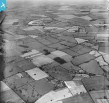
EPW017454 ENGLAND (1927). Countryside around Davenport Green from Etrop Green now on the site of the airport, Manchester International Airport, from the south-east, 1927
© Copyright OpenStreetMap contributors and licensed by the OpenStreetMap Foundation. 2024. Cartography is licensed as CC BY-SA.
Details
| Title | [EPW017454] Countryside around Davenport Green from Etrop Green now on the site of the airport, Manchester International Airport, from the south-east, 1927 |
| Reference | EPW017454 |
| Date | 8-March-1927 |
| Link | |
| Place name | MANCHESTER INTERNATIONAL AIRPORT |
| Parish | RINGWAY |
| District | |
| Country | ENGLAND |
| Easting / Northing | 381075, 385954 |
| Longitude / Latitude | -2.2844624251592, 53.369845660709 |
| National Grid Reference | SJ811860 |
Pins
 John Ellis |
Sunday 21st of October 2012 04:26:39 PM | |
 David Hartley |
Saturday 21st of July 2012 09:00:33 PM | |
 David Hartley |
Saturday 21st of July 2012 08:59:13 PM | |
Is that the same as Newall Green Farm - now sadly decaying? |
 John Ellis |
Sunday 21st of October 2012 04:28:13 PM |
 John Ellis |
Monday 9th of July 2012 07:10:00 AM | |
 John Ellis |
Monday 9th of July 2012 07:05:14 AM | |
 John Ellis |
Monday 2nd of July 2012 08:47:27 PM | |
 John Ellis |
Monday 2nd of July 2012 08:42:51 PM | |
 John Ellis |
Monday 2nd of July 2012 08:39:59 PM | |
 John Ellis |
Monday 2nd of July 2012 08:39:22 PM | |
 John Ellis |
Monday 2nd of July 2012 08:35:44 PM | |
 John Ellis |
Monday 2nd of July 2012 07:31:56 AM | |
 John Ellis |
Monday 2nd of July 2012 07:31:08 AM | |
 John Ellis |
Monday 2nd of July 2012 07:30:25 AM | |
 John Ellis |
Monday 2nd of July 2012 07:28:42 AM | |
 John Ellis |
Monday 2nd of July 2012 07:27:43 AM | |
 John Ellis |
Monday 2nd of July 2012 07:26:43 AM | |
 John Ellis |
Monday 2nd of July 2012 07:25:26 AM | |
 John Ellis |
Monday 2nd of July 2012 07:24:51 AM | |
 John Ellis |
Monday 2nd of July 2012 07:23:58 AM | |
 John Ellis |
Monday 2nd of July 2012 07:23:14 AM | |
 John Ellis |
Monday 2nd of July 2012 07:22:35 AM | |
 John Ellis |
Monday 2nd of July 2012 07:21:23 AM | |
 John Ellis |
Monday 2nd of July 2012 07:20:43 AM | |
 John Ellis |
Monday 2nd of July 2012 07:19:45 AM | |
 John Ellis |
Monday 2nd of July 2012 07:17:46 AM | |
 John Ellis |
Monday 2nd of July 2012 07:17:06 AM | |
 John Ellis |
Monday 2nd of July 2012 07:16:14 AM | |
 John Ellis |
Monday 2nd of July 2012 07:15:26 AM | |
 John Ellis |
Monday 2nd of July 2012 07:14:51 AM | |
 John Ellis |
Monday 2nd of July 2012 07:14:11 AM | |
 John Ellis |
Monday 2nd of July 2012 07:13:28 AM | |
 John Ellis |
Monday 2nd of July 2012 07:12:49 AM |
User Comment Contributions
 IanPlant |
Tuesday 18th of February 2014 09:24:15 PM |


