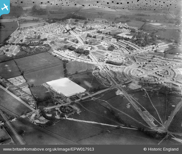
EPW017913 ENGLAND (1927). Housing Estate under construction, Low Hill, 1927
© Copyright OpenStreetMap contributors and licensed by the OpenStreetMap Foundation. 2025. Cartography is licensed as CC BY-SA.
Nearby Images (11)
Details
| Title | [EPW017913] Housing Estate under construction, Low Hill, 1927 |
| Reference | EPW017913 |
| Date | 11-May-1927 |
| Link | |
| Place name | LOW HILL |
| Parish | |
| District | |
| Country | ENGLAND |
| Easting / Northing | 392269, 301102 |
| Longitude / Latitude | -2.1141761321033, 52.607290149056 |
| National Grid Reference | SJ923011 |
Pins
Be the first to add a comment to this image!


![[EPW017913] Housing Estate under construction, Low Hill, 1927](http://britainfromabove.org.uk/sites/all/libraries/aerofilms-images/public/100x100/EPW/017/EPW017913.jpg)
![[EPW017919] Housing Estate under construction, Low Hill, from the south-west, 1927](http://britainfromabove.org.uk/sites/all/libraries/aerofilms-images/public/100x100/EPW/017/EPW017919.jpg)
![[EPW017918] Housing Estate under construction, Low Hill, 1927](http://britainfromabove.org.uk/sites/all/libraries/aerofilms-images/public/100x100/EPW/017/EPW017918.jpg)
![[EPW021036] Alfred Herbet Ltd Steel Works and Humphreys Road, Wolverhampton, 1928](http://britainfromabove.org.uk/sites/all/libraries/aerofilms-images/public/100x100/EPW/021/EPW021036.jpg)
![[EPW021035] Alfred Herbet Ltd Steel Works, Wolverhampton, 1928](http://britainfromabove.org.uk/sites/all/libraries/aerofilms-images/public/100x100/EPW/021/EPW021035.jpg)
![[EPW021039] Alfred Herbet Ltd Steel Works, Wolverhampton, 1928](http://britainfromabove.org.uk/sites/all/libraries/aerofilms-images/public/100x100/EPW/021/EPW021039.jpg)
![[EPW021033] Alfred Herbet Ltd Steel Works, Wolverhampton, 1928](http://britainfromabove.org.uk/sites/all/libraries/aerofilms-images/public/100x100/EPW/021/EPW021033.jpg)
![[EPW021038] Alfred Herbet Ltd Steel Works, Wolverhampton, 1928](http://britainfromabove.org.uk/sites/all/libraries/aerofilms-images/public/100x100/EPW/021/EPW021038.jpg)
![[EPW021037] Alfred Herbet Ltd Steel Works, Wolverhampton, 1928](http://britainfromabove.org.uk/sites/all/libraries/aerofilms-images/public/100x100/EPW/021/EPW021037.jpg)
![[EPW021034] Alfred Herbet Ltd Steel Works and Fourth Avenue, Wolverhampton, 1928](http://britainfromabove.org.uk/sites/all/libraries/aerofilms-images/public/100x100/EPW/021/EPW021034.jpg)
![[EPW021041] Alfred Herbet Ltd Steel Works, Wolverhampton, 1928](http://britainfromabove.org.uk/sites/all/libraries/aerofilms-images/public/100x100/EPW/021/EPW021041.jpg)