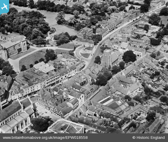
EPW018558 ENGLAND (1927). All Saints Church, the war memorial, and environs, Colchester, 1927
© Copyright OpenStreetMap contributors and licensed by the OpenStreetMap Foundation. 2025. Cartography is licensed as CC BY-SA.
Nearby Images (35)
Details
| Title | [EPW018558] All Saints Church, the war memorial, and environs, Colchester, 1927 |
| Reference | EPW018558 |
| Date | 20-June-1927 |
| Link | |
| Place name | COLCHESTER |
| Parish | |
| District | |
| Country | ENGLAND |
| Easting / Northing | 599883, 225215 |
| Longitude / Latitude | 0.90500779333958, 51.889155696254 |
| National Grid Reference | TL999252 |
Pins
 PrezAlan |
Saturday 14th of March 2015 03:03:49 PM | |
 woodsy007 |
Monday 17th of November 2014 08:53:57 PM | |
 woodsy007 |
Monday 17th of November 2014 08:52:42 PM | |
 MB |
Sunday 7th of October 2012 11:32:46 PM | |
 MB |
Sunday 7th of October 2012 11:30:48 PM | |
 MB |
Sunday 7th of October 2012 11:29:12 PM | |
 MB |
Sunday 7th of October 2012 11:28:45 PM | |
 MB |
Sunday 7th of October 2012 11:28:21 PM | |
 MB |
Sunday 7th of October 2012 11:24:30 PM | |
 MB |
Sunday 7th of October 2012 11:23:51 PM | |
More recently a museum |
 MB |
Sunday 7th of October 2012 11:29:40 PM |
 MB |
Sunday 7th of October 2012 11:20:47 PM | |
 MB |
Sunday 7th of October 2012 11:20:22 PM | |
 MB |
Sunday 7th of October 2012 11:13:54 PM | |
 MB |
Sunday 7th of October 2012 11:13:03 PM | |
 MB |
Sunday 7th of October 2012 11:12:31 PM | |
 MB |
Sunday 7th of October 2012 11:11:30 PM |


![[EPW018558] All Saints Church, the war memorial, and environs, Colchester, 1927](http://britainfromabove.org.uk/sites/all/libraries/aerofilms-images/public/100x100/EPW/018/EPW018558.jpg)
![[EAW029729] The High Street and town, Colchester, 1950](http://britainfromabove.org.uk/sites/all/libraries/aerofilms-images/public/100x100/EAW/029/EAW029729.jpg)
![[EPW016543] Colchester Castle and the town, Colchester, 1926](http://britainfromabove.org.uk/sites/all/libraries/aerofilms-images/public/100x100/EPW/016/EPW016543.jpg)
![[EAW013999] The High Street and town, Colchester, from the north-east, 1948](http://britainfromabove.org.uk/sites/all/libraries/aerofilms-images/public/100x100/EAW/013/EAW013999.jpg)
![[EAW014003] Cowdray Crescent and the Castle, Colchester, from the south-east, 1948](http://britainfromabove.org.uk/sites/all/libraries/aerofilms-images/public/100x100/EAW/014/EAW014003.jpg)
![[EPW018549] Colchester Castle and the town centre, Colchester, 1927](http://britainfromabove.org.uk/sites/all/libraries/aerofilms-images/public/100x100/EPW/018/EPW018549.jpg)
![[EAW014006] The Castle and environs, Colchester, 1948](http://britainfromabove.org.uk/sites/all/libraries/aerofilms-images/public/100x100/EAW/014/EAW014006.jpg)
![[EAW008093] Colchester Castle, Colchester, 1947. This image has been produced from a print.](http://britainfromabove.org.uk/sites/all/libraries/aerofilms-images/public/100x100/EAW/008/EAW008093.jpg)
![[EAW008094] Colchester Castle, Colchester, 1947. This image has been produced from a print marked by Aerofilms Ltd for photo editing.](http://britainfromabove.org.uk/sites/all/libraries/aerofilms-images/public/100x100/EAW/008/EAW008094.jpg)
![[EAW008091] Colchester Castle, Colchester, 1947](http://britainfromabove.org.uk/sites/all/libraries/aerofilms-images/public/100x100/EAW/008/EAW008091.jpg)
![[EAW037253] The Castle Museum, High Street and town centre, Colchester, 1951. This image has been produced from a print.](http://britainfromabove.org.uk/sites/all/libraries/aerofilms-images/public/100x100/EAW/037/EAW037253.jpg)
![[EAW029734] The Castle, Colchester, 1950](http://britainfromabove.org.uk/sites/all/libraries/aerofilms-images/public/100x100/EAW/029/EAW029734.jpg)
![[EAW014005] The Castle and environs, Colchester, 1948](http://britainfromabove.org.uk/sites/all/libraries/aerofilms-images/public/100x100/EAW/014/EAW014005.jpg)
![[EAW014002] The High Street, Colchester, 1948](http://britainfromabove.org.uk/sites/all/libraries/aerofilms-images/public/100x100/EAW/014/EAW014002.jpg)
![[EAW014009] The Castle and environs, Colchester, 1948. This image has been produced from a damaged negative.](http://britainfromabove.org.uk/sites/all/libraries/aerofilms-images/public/100x100/EAW/014/EAW014009.jpg)
![[EAW015360] The town, Colchester, 1948](http://britainfromabove.org.uk/sites/all/libraries/aerofilms-images/public/100x100/EAW/015/EAW015360.jpg)
![[EAW014004] The Castle and Castle Park, Colchester, 1948](http://britainfromabove.org.uk/sites/all/libraries/aerofilms-images/public/100x100/EAW/014/EAW014004.jpg)
![[EAW014007] The Castle and environs, Colchester, 1948](http://britainfromabove.org.uk/sites/all/libraries/aerofilms-images/public/100x100/EAW/014/EAW014007.jpg)
![[EAW008095] Colchester Castle, Colchester, 1947. This image has been produced from a print.](http://britainfromabove.org.uk/sites/all/libraries/aerofilms-images/public/100x100/EAW/008/EAW008095.jpg)
![[EAW037254] The Castle Museum, High Street and town centre, Colchester, 1951. This image has been produced from a print.](http://britainfromabove.org.uk/sites/all/libraries/aerofilms-images/public/100x100/EAW/037/EAW037254.jpg)
![[EPW058740] The town centre, Colchester, 1938](http://britainfromabove.org.uk/sites/all/libraries/aerofilms-images/public/100x100/EPW/058/EPW058740.jpg)
![[EAW008092] Colchester Castle, Colchester, 1947. This image has been produced from a print.](http://britainfromabove.org.uk/sites/all/libraries/aerofilms-images/public/100x100/EAW/008/EAW008092.jpg)
![[EAW037499] The town centre, Colchester, 1951. This image has been produced from a print.](http://britainfromabove.org.uk/sites/all/libraries/aerofilms-images/public/100x100/EAW/037/EAW037499.jpg)
![[EAW014008] The Castle and environs, Colchester, 1948. This image has been produced from a damaged negative.](http://britainfromabove.org.uk/sites/all/libraries/aerofilms-images/public/100x100/EAW/014/EAW014008.jpg)
![[EAW037491] The High Street and Colchester Castle, Colchester, 1951. This image has been produced from a print.](http://britainfromabove.org.uk/sites/all/libraries/aerofilms-images/public/100x100/EAW/037/EAW037491.jpg)
![[EPW018546] The town around East Hill, Colchester, 1927](http://britainfromabove.org.uk/sites/all/libraries/aerofilms-images/public/100x100/EPW/018/EPW018546.jpg)
![[EAW037495] The town centre, Colchester, 1951. This image has been produced from a print.](http://britainfromabove.org.uk/sites/all/libraries/aerofilms-images/public/100x100/EAW/037/EAW037495.jpg)
![[EAW037498] The town centre, Colchester, 1951. This image has been produced from a print.](http://britainfromabove.org.uk/sites/all/libraries/aerofilms-images/public/100x100/EAW/037/EAW037498.jpg)
![[EAW014010] The town, Colchester, from the north-east, 1948. This image has been produced from a damaged negative.](http://britainfromabove.org.uk/sites/all/libraries/aerofilms-images/public/100x100/EAW/014/EAW014010.jpg)
![[EPW018550] Colchester Castle, Castle Park, and the town centre, Colchester, 1927](http://britainfromabove.org.uk/sites/all/libraries/aerofilms-images/public/100x100/EPW/018/EPW018550.jpg)
![[EAW024677] The High Street and town, Colchester, from the west, 1949](http://britainfromabove.org.uk/sites/all/libraries/aerofilms-images/public/100x100/EAW/024/EAW024677.jpg)
![[EAW029728] Osborne Street, St John's Street and the town, Colchester, 1950](http://britainfromabove.org.uk/sites/all/libraries/aerofilms-images/public/100x100/EAW/029/EAW029728.jpg)
![[EAW029730] The town, Colchester, 1950](http://britainfromabove.org.uk/sites/all/libraries/aerofilms-images/public/100x100/EAW/029/EAW029730.jpg)
![[EAW056122] The town centre, Colchester, 1954](http://britainfromabove.org.uk/sites/all/libraries/aerofilms-images/public/100x100/EAW/056/EAW056122.jpg)