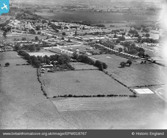
EPW018767 ENGLAND (1927). The Watling Estate, Edgware, 1927
© Copyright OpenStreetMap contributors and licensed by the OpenStreetMap Foundation. 2025. Cartography is licensed as CC BY-SA.
Nearby Images (27)
Details
| Title | [EPW018767] The Watling Estate, Edgware, 1927 |
| Reference | EPW018767 |
| Date | 8-July-1927 |
| Link | |
| Place name | EDGWARE |
| Parish | |
| District | |
| Country | ENGLAND |
| Easting / Northing | 519820, 190462 |
| Longitude / Latitude | -0.26979820139092, 51.59976638374 |
| National Grid Reference | TQ198905 |
Pins
 Danish A |
Wednesday 29th of November 2017 12:39:09 AM | |
 Danish A |
Wednesday 29th of November 2017 12:35:56 AM | |
 simes188 |
Sunday 24th of November 2013 10:38:52 PM | |
 Class31 |
Wednesday 22nd of August 2012 09:42:53 AM | |
 Class31 |
Wednesday 22nd of August 2012 09:41:53 AM |
User Comment Contributions
View looking east. |
 Class31 |
Wednesday 22nd of August 2012 09:43:20 AM |


![[EPW018767] The Watling Estate, Edgware, 1927](http://britainfromabove.org.uk/sites/all/libraries/aerofilms-images/public/100x100/EPW/018/EPW018767.jpg)
![[EPW018771] Construction of the Watling Estate, Edgware, 1927](http://britainfromabove.org.uk/sites/all/libraries/aerofilms-images/public/100x100/EPW/018/EPW018771.jpg)
![[EPW018774] Construction of the Watling Estate, Edgware, 1927](http://britainfromabove.org.uk/sites/all/libraries/aerofilms-images/public/100x100/EPW/018/EPW018774.jpg)
![[EPW034799] Stag Lane Aerodrome, Edgware Road and environs, Little Stanmore, from the south-east, 1931. This image has been produced from a damaged negative.](http://britainfromabove.org.uk/sites/all/libraries/aerofilms-images/public/100x100/EPW/034/EPW034799.jpg)
![[EPW018773] Construction of the Watling Estate, Edgware, 1927](http://britainfromabove.org.uk/sites/all/libraries/aerofilms-images/public/100x100/EPW/018/EPW018773.jpg)
![[EPW018772] Construction of the Watling Estate, Edgware, 1927](http://britainfromabove.org.uk/sites/all/libraries/aerofilms-images/public/100x100/EPW/018/EPW018772.jpg)
![[EPW018769] Construction of the Watling Estate, Edgware, 1927](http://britainfromabove.org.uk/sites/all/libraries/aerofilms-images/public/100x100/EPW/018/EPW018769.jpg)
![[EPW018766] Construction of the Watling Estate, Edgware, 1927](http://britainfromabove.org.uk/sites/all/libraries/aerofilms-images/public/100x100/EPW/018/EPW018766.jpg)
![[EPW018768] Construction of the Watling Estate, Edgware, 1927](http://britainfromabove.org.uk/sites/all/libraries/aerofilms-images/public/100x100/EPW/018/EPW018768.jpg)
![[EPW017584] Argyll Gardens and Kenmore Gardens under construction, Little Stanmore, 1927](http://britainfromabove.org.uk/sites/all/libraries/aerofilms-images/public/100x100/EPW/017/EPW017584.jpg)
![[EPW022362] Stag Lane Aerodrome, Little Stanmore, from the north-east, 1928](http://britainfromabove.org.uk/sites/all/libraries/aerofilms-images/public/100x100/EPW/022/EPW022362.jpg)
![[EPW017583] Stag Lane, Queensbury, 1927](http://britainfromabove.org.uk/sites/all/libraries/aerofilms-images/public/100x100/EPW/017/EPW017583.jpg)
![[EPW015845] DH9A J7028 "Stag" undergoing flight trials at Stag Lane, Little Stanmore, 1926](http://britainfromabove.org.uk/sites/all/libraries/aerofilms-images/public/100x100/EPW/015/EPW015845.jpg)
![[EPW015848] DH9A J7028 "Stag" undergoing flight trials at Stag Lane, Little Stanmore, 1926](http://britainfromabove.org.uk/sites/all/libraries/aerofilms-images/public/100x100/EPW/015/EPW015848.jpg)
![[EPW015847] DH9A J7028 "Stag" undergoing flight trials at Stag Lane, Little Stanmore, 1926](http://britainfromabove.org.uk/sites/all/libraries/aerofilms-images/public/100x100/EPW/015/EPW015847.jpg)
![[EPW015850] DH9A J7028 "Stag" undergoing flight trials at Stag Lane, Little Stanmore, 1926](http://britainfromabove.org.uk/sites/all/libraries/aerofilms-images/public/100x100/EPW/015/EPW015850.jpg)
![[EPW015851] DH9A J7028 "Stag" undergoing flight trials at Stag Lane, Little Stanmore, 1926](http://britainfromabove.org.uk/sites/all/libraries/aerofilms-images/public/100x100/EPW/015/EPW015851.jpg)
![[EPW015849] DH9A J7028 "Stag" undergoing flight trials at Stag Lane, Little Stanmore, 1926](http://britainfromabove.org.uk/sites/all/libraries/aerofilms-images/public/100x100/EPW/015/EPW015849.jpg)
![[EPW031546] Stag Lane Aerodrome and surroundings, Little Stanmore, from the south, 1930](http://britainfromabove.org.uk/sites/all/libraries/aerofilms-images/public/100x100/EPW/031/EPW031546.jpg)
![[EPW015852] DH9A J7028 "Stag" undergoing flight trials at Stag Lane, Little Stanmore, 1926](http://britainfromabove.org.uk/sites/all/libraries/aerofilms-images/public/100x100/EPW/015/EPW015852.jpg)
![[EPW018770] Construction of the Watling Estate, Queensbury, from the south, 1927](http://britainfromabove.org.uk/sites/all/libraries/aerofilms-images/public/100x100/EPW/018/EPW018770.jpg)
![[EPW030056] The Youth of Britain at Stag Lane Aerodrome following Sir Alan Cobham's tour of Britain, 1929](http://britainfromabove.org.uk/sites/all/libraries/aerofilms-images/public/100x100/EPW/030/EPW030056.jpg)
![[EPW032891] The de Havilland Works at Stag Lane Aerodrome, Queensbury, from the north-east, 1930](http://britainfromabove.org.uk/sites/all/libraries/aerofilms-images/public/100x100/EPW/032/EPW032891.jpg)
![[EPW025691] Stag Lane Aerodrome, Little Stanmore, 1929](http://britainfromabove.org.uk/sites/all/libraries/aerofilms-images/public/100x100/EPW/025/EPW025691.jpg)
![[EPW019193] Barnfield Road and the Redhill Institution, Burnt Oak, 1927](http://britainfromabove.org.uk/sites/all/libraries/aerofilms-images/public/100x100/EPW/019/EPW019193.jpg)
![[EPW030057] Little Stanmore, Sir Alan Cobham finishes his 21 weeks' flying tour of Britain at Stag Lane Aerodrome, 1929](http://britainfromabove.org.uk/sites/all/libraries/aerofilms-images/public/100x100/EPW/030/EPW030057.jpg)
![[EPW030058] Little Stanmore, Sir Alan Cobham finishes his 21 weeks' flying tour of Britain at Stag Lane Aerodrome, 1929](http://britainfromabove.org.uk/sites/all/libraries/aerofilms-images/public/100x100/EPW/030/EPW030058.jpg)