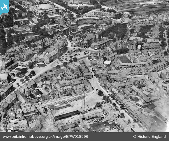
EPW018996 ENGLAND (1927). The Market Place, Town Hall and environs, Buxton, 1927
© Copyright OpenStreetMap contributors and licensed by the OpenStreetMap Foundation. 2025. Cartography is licensed as CC BY-SA.
Nearby Images (12)
Details
| Title | [EPW018996] The Market Place, Town Hall and environs, Buxton, 1927 |
| Reference | EPW018996 |
| Date | 25-July-1927 |
| Link | |
| Place name | BUXTON |
| Parish | |
| District | |
| Country | ENGLAND |
| Easting / Northing | 405841, 373205 |
| Longitude / Latitude | -1.9124380081979, 53.255542184186 |
| National Grid Reference | SK058732 |
Pins
 Maitland |
Friday 28th of November 2014 05:11:45 PM | |
 Peter |
Monday 12th of November 2012 08:03:49 PM | |
+ up until the 1970's, the building had the largest unsupported dome in the world. |
 Ray(T) |
Wednesday 2nd of October 2013 01:11:41 PM |
 Class31 |
Tuesday 30th of October 2012 11:12:07 PM | |
 Class31 |
Tuesday 30th of October 2012 11:11:24 PM | |
 Class31 |
Tuesday 30th of October 2012 11:10:46 PM |


![[EPW018996] The Market Place, Town Hall and environs, Buxton, 1927](http://britainfromabove.org.uk/sites/all/libraries/aerofilms-images/public/100x100/EPW/018/EPW018996.jpg)
![[EPW023810] The Buxton Hydropathic Hotel and environs, Buxton, 1928](http://britainfromabove.org.uk/sites/all/libraries/aerofilms-images/public/100x100/EPW/023/EPW023810.jpg)
![[EPW023807] The Buxton Hydropathic Hotel, Buxton, 1928](http://britainfromabove.org.uk/sites/all/libraries/aerofilms-images/public/100x100/EPW/023/EPW023807.jpg)
![[EPW023808] The Buxton Hydropathic Hotel and Buxton Gardens, Buxton, 1928](http://britainfromabove.org.uk/sites/all/libraries/aerofilms-images/public/100x100/EPW/023/EPW023808.jpg)
![[EPW023811] The Buxton Hydropathic Hotel and environs, Buxton, 1928](http://britainfromabove.org.uk/sites/all/libraries/aerofilms-images/public/100x100/EPW/023/EPW023811.jpg)
![[EPW023809] The Buxton Hydropathic Hotel and environs, Buxton, 1928](http://britainfromabove.org.uk/sites/all/libraries/aerofilms-images/public/100x100/EPW/023/EPW023809.jpg)
![[EPW023814] The Buxton Hydropathic Hotel and environs, Buxton, 1928](http://britainfromabove.org.uk/sites/all/libraries/aerofilms-images/public/100x100/EPW/023/EPW023814.jpg)
![[EPW023840] Buxton Hydro, Buxton Gardens and environs, Buxton, 1928](http://britainfromabove.org.uk/sites/all/libraries/aerofilms-images/public/100x100/EPW/023/EPW023840.jpg)
![[EPW023812] The Buxton Hydropathic Hotel and environs, Buxton, 1928](http://britainfromabove.org.uk/sites/all/libraries/aerofilms-images/public/100x100/EPW/023/EPW023812.jpg)
![[EPW023813] The town centre, Buxton, 1928](http://britainfromabove.org.uk/sites/all/libraries/aerofilms-images/public/100x100/EPW/023/EPW023813.jpg)
![[EPW034109] Buxton Gardens, the Buxton Hydro and Higher Buxton, Buxton, 1930](http://britainfromabove.org.uk/sites/all/libraries/aerofilms-images/public/100x100/EPW/034/EPW034109.jpg)
![[EPW018995] Buxton Gardens, Buxton, 1927. This image has been produced from a damaged print.](http://britainfromabove.org.uk/sites/all/libraries/aerofilms-images/public/100x100/EPW/018/EPW018995.jpg)