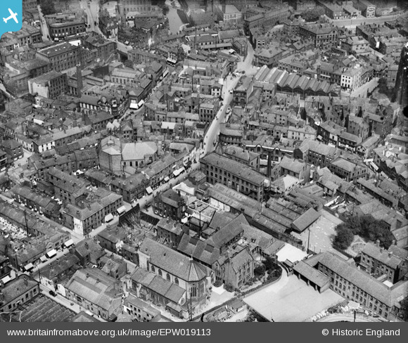
EPW019113 ENGLAND (1927). St Petersgate, Stockport, 1927
© Copyright OpenStreetMap contributors and licensed by the OpenStreetMap Foundation. 2025. Cartography is licensed as CC BY-SA.
Nearby Images (5)
Details
| Title | [EPW019113] St Petersgate, Stockport, 1927 |
| Reference | EPW019113 |
| Date | 4-August-1927 |
| Link | |
| Place name | STOCKPORT |
| Parish | |
| District | |
| Country | ENGLAND |
| Easting / Northing | 389626, 390410 |
| Longitude / Latitude | -2.1560792023229, 53.410140372857 |
| National Grid Reference | SJ896904 |
Pins
 John Ellis |
Tuesday 7th of August 2012 10:28:07 PM | |
 John Ellis |
Tuesday 7th of August 2012 10:26:00 PM | |
 John Ellis |
Tuesday 7th of August 2012 10:25:30 PM | |
 totoro |
Monday 25th of June 2012 05:15:45 PM | |
 totoro |
Monday 25th of June 2012 04:59:07 PM | |
 totoro |
Monday 25th of June 2012 04:37:58 PM | |
 totoro |
Monday 25th of June 2012 04:33:23 PM | |
 totoro |
Monday 25th of June 2012 04:27:43 PM | |
 totoro |
Monday 25th of June 2012 04:25:16 PM | |
 totoro |
Monday 25th of June 2012 04:22:25 PM | |
 totoro |
Monday 25th of June 2012 04:19:25 PM | |
 totoro |
Monday 25th of June 2012 04:16:54 PM | |
 totoro |
Monday 25th of June 2012 04:15:50 PM |


![[EPW019113] St Petersgate, Stockport, 1927](http://britainfromabove.org.uk/sites/all/libraries/aerofilms-images/public/100x100/EPW/019/EPW019113.jpg)
![[EPW019112] The High Street and environs, Stockport, 1927](http://britainfromabove.org.uk/sites/all/libraries/aerofilms-images/public/100x100/EPW/019/EPW019112.jpg)
![[EPW019111] St Mary's Church and the Unicorn Brewery, Stockport, 1927](http://britainfromabove.org.uk/sites/all/libraries/aerofilms-images/public/100x100/EPW/019/EPW019111.jpg)
![[EPW013110] The River Mersey between Lancashire Bridge and Mersey Bridge, Stockport, 1925. This image has been produced from a copy-negative.](http://britainfromabove.org.uk/sites/all/libraries/aerofilms-images/public/100x100/EPW/013/EPW013110.jpg)
![[EPW013108] Adlington Square Mills, Stockport, 1925. This image has been produced from a print.](http://britainfromabove.org.uk/sites/all/libraries/aerofilms-images/public/100x100/EPW/013/EPW013108.jpg)