
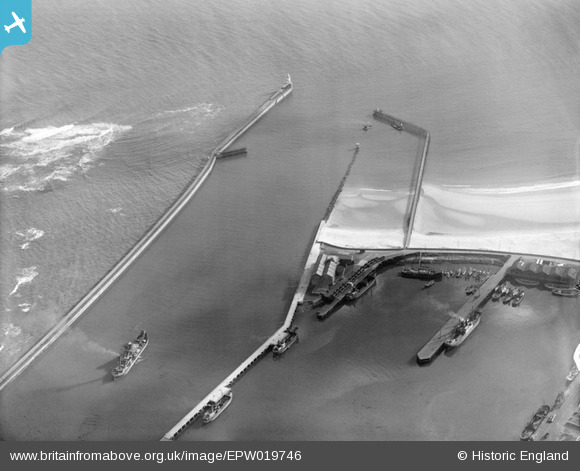
EPW019746 ENGLAND (1927). The harbour entrance, Blyth, 1927
© Copyright OpenStreetMap contributors and licensed by the OpenStreetMap Foundation. 2025. Cartography is licensed as CC BY-SA.
Nearby Images (6)
EPW019746

EPW048836

EPW048822

EPW019751

EAW052312

EPW048837

Details
| Title | [EPW019746] The harbour entrance, Blyth, 1927 |
| Reference | EPW019746 |
| Date | 18-October-1927 |
| Link | |
| Place name | BLYTH |
| Parish | BLYTH |
| District | |
| Country | ENGLAND |
| Easting / Northing | 432488, 580682 |
| Longitude / Latitude | -1.4905598849111, 55.11940212411 |
| National Grid Reference | NZ325807 |
Pins
 Erlbon |
Tuesday 2nd of June 2020 10:38:03 AM | |
Gerald Pile |
Tuesday 5th of May 2015 02:07:54 PM |
User Comment Contributions
The photograph shows the fairway and the two basins which form the South Harbour. The east basin has been home to Royal Northumberland Yacht Club for over a century. When this picture was taken in 1927, the Club's Headquarters vessel was an ex-Admiralty concrete tug called the Cretehatch which is moored to a dolphin. Members' yachts were on moorings in the vicinity. The photograph also shows the 'Ice House' snuggled into the corner of the east basin, and the 'German Sheds' in the West Basin. |
Bruce |
Wednesday 3rd of February 2016 04:05:40 PM |
Thanks for that Bruce - My Grandfather served as stoker on the Cretehatch in January/February 1921 - presumably just after it was built. |
Ray(T) |
Wednesday 3rd of February 2016 04:05:40 PM |