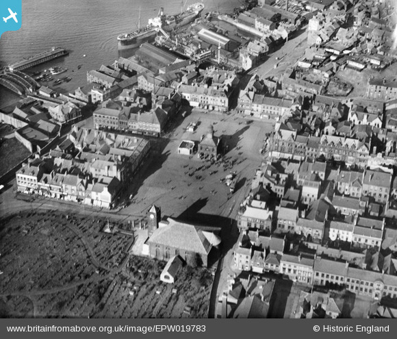
EPW019783 ENGLAND (1927). The Market Place, St Hilda's Church and the waterfront, South Shields, 1927
© Copyright OpenStreetMap contributors and licensed by the OpenStreetMap Foundation. 2025. Cartography is licensed as CC BY-SA.
Details
| Title | [EPW019783] The Market Place, St Hilda's Church and the waterfront, South Shields, 1927 |
| Reference | EPW019783 |
| Date | 20-October-1927 |
| Link | |
| Place name | SOUTH SHIELDS |
| Parish | |
| District | |
| Country | ENGLAND |
| Easting / Northing | 436060, 567133 |
| Longitude / Latitude | -1.4362642404327, 54.997394358033 |
| National Grid Reference | NZ361671 |
Pins
 Laura |
Sunday 22nd of January 2017 03:01:43 PM | |
 Caro Barnsley |
Friday 25th of July 2014 12:10:18 PM | |
 Caro Barnsley |
Friday 25th of July 2014 09:13:24 AM | |
 Caro Barnsley |
Friday 25th of July 2014 09:11:48 AM | |
 Caro Barnsley |
Friday 25th of July 2014 09:11:02 AM | |
 N Dunn |
Saturday 7th of December 2013 02:55:20 PM | |
 N Dunn |
Saturday 14th of September 2013 01:17:17 PM | |
 N Dunn |
Saturday 14th of September 2013 01:15:12 PM | |
 SC |
Tuesday 15th of January 2013 02:41:52 PM | |
 SC |
Tuesday 15th of January 2013 02:36:11 PM | |
 SC |
Tuesday 15th of January 2013 02:33:20 PM | |
 SC |
Tuesday 15th of January 2013 02:31:58 PM |


![[EPW019783] The Market Place, St Hilda's Church and the waterfront, South Shields, 1927](http://britainfromabove.org.uk/sites/all/libraries/aerofilms-images/public/100x100/EPW/019/EPW019783.jpg)
![[EPW019781] Thrift Street and Graving Docks, South Shields, 1927](http://britainfromabove.org.uk/sites/all/libraries/aerofilms-images/public/100x100/EPW/019/EPW019781.jpg)
![[EAW014535] Harton Low Staithes, South Shields, 1948. This image has been produced from a print.](http://britainfromabove.org.uk/sites/all/libraries/aerofilms-images/public/100x100/EAW/014/EAW014535.jpg)
![[EPW019784] North Street and South Shields Railway Station, South Shields, 1927](http://britainfromabove.org.uk/sites/all/libraries/aerofilms-images/public/100x100/EPW/019/EPW019784.jpg)


