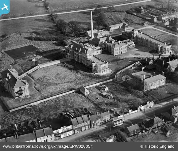
EPW020054 ENGLAND (1927). Redhill County Hospital, Burnt Oak, 1927
© Copyright OpenStreetMap contributors and licensed by the OpenStreetMap Foundation. 2025. Cartography is licensed as CC BY-SA.
Nearby Images (27)
Details
| Title | [EPW020054] Redhill County Hospital, Burnt Oak, 1927 |
| Reference | EPW020054 |
| Date | 4-November-1927 |
| Link | |
| Place name | BURNT OAK |
| Parish | |
| District | |
| Country | ENGLAND |
| Easting / Northing | 519750, 191061 |
| Longitude / Latitude | -0.27060393400273, 51.605165235679 |
| National Grid Reference | TQ198911 |
Pins
 John Wass |
Friday 20th of May 2016 04:27:21 PM |


![[EPW020054] Redhill County Hospital, Burnt Oak, 1927](http://britainfromabove.org.uk/sites/all/libraries/aerofilms-images/public/100x100/EPW/020/EPW020054.jpg)
![[EPW020056] Redhill County Hospital and High Road, Burnt Oak, 1927](http://britainfromabove.org.uk/sites/all/libraries/aerofilms-images/public/100x100/EPW/020/EPW020056.jpg)
![[EAW028467] The Edgware General Hospital and the surrounding residential area, Burnt Oak, 1950](http://britainfromabove.org.uk/sites/all/libraries/aerofilms-images/public/100x100/EAW/028/EAW028467.jpg)
![[EPW020055] Redhill County Hospital, Burnt Oak, 1927](http://britainfromabove.org.uk/sites/all/libraries/aerofilms-images/public/100x100/EPW/020/EPW020055.jpg)
![[EPW001354] The Union Schools, Burnt Oak, 1920](http://britainfromabove.org.uk/sites/all/libraries/aerofilms-images/public/100x100/EPW/001/EPW001354.jpg)
![[EPW020058] Redhill County Hospital, Burnt Oak, 1927](http://britainfromabove.org.uk/sites/all/libraries/aerofilms-images/public/100x100/EPW/020/EPW020058.jpg)
![[EPW001355] The High Road, Burnt Oak, 1920](http://britainfromabove.org.uk/sites/all/libraries/aerofilms-images/public/100x100/EPW/001/EPW001355.jpg)
![[EPW020061] Redhill County Hospital, Burnt Oak, 1927](http://britainfromabove.org.uk/sites/all/libraries/aerofilms-images/public/100x100/EPW/020/EPW020061.jpg)
![[EPW020060] Redhill County Hospital and Musical Instrument Works, Burnt Oak, 1927](http://britainfromabove.org.uk/sites/all/libraries/aerofilms-images/public/100x100/EPW/020/EPW020060.jpg)
![[EPW020059] Redhill County Hospital and Musical Instrument Works, Burnt Oak, 1927](http://britainfromabove.org.uk/sites/all/libraries/aerofilms-images/public/100x100/EPW/020/EPW020059.jpg)
![[EPW015981] The Redhill County Hospital under construction and the Musical Instrument Works, Burnt Oak, 1926](http://britainfromabove.org.uk/sites/all/libraries/aerofilms-images/public/100x100/EPW/015/EPW015981.jpg)
![[EPW020062] Redhill County Hospital, Burnt Oak, 1927](http://britainfromabove.org.uk/sites/all/libraries/aerofilms-images/public/100x100/EPW/020/EPW020062.jpg)
![[EPW020057] Redhill County Hospital and Musical Instrument Works, Burnt Oak, 1927](http://britainfromabove.org.uk/sites/all/libraries/aerofilms-images/public/100x100/EPW/020/EPW020057.jpg)
![[EAW028461] The Edgware General Hospital and the surrounding residential area, Burnt Oak, 1950](http://britainfromabove.org.uk/sites/all/libraries/aerofilms-images/public/100x100/EAW/028/EAW028461.jpg)
![[EAW028459] The Edgware General Hospital and the surrounding residential area, Burnt Oak, 1950](http://britainfromabove.org.uk/sites/all/libraries/aerofilms-images/public/100x100/EAW/028/EAW028459.jpg)
![[EAW028466] The Edgware General Hospital and the surrounding residential area, Burnt Oak, 1950](http://britainfromabove.org.uk/sites/all/libraries/aerofilms-images/public/100x100/EAW/028/EAW028466.jpg)
![[EAW028463] The Edgware General Hospital and the surrounding residential area, Burnt Oak, 1950](http://britainfromabove.org.uk/sites/all/libraries/aerofilms-images/public/100x100/EAW/028/EAW028463.jpg)
![[EAW028464] The Edgware General Hospital and the surrounding residential area, Burnt Oak, 1950](http://britainfromabove.org.uk/sites/all/libraries/aerofilms-images/public/100x100/EAW/028/EAW028464.jpg)
![[EPW016826] The Hawkes and Co. Musical Instrument Works, Burnt Oak, 1926](http://britainfromabove.org.uk/sites/all/libraries/aerofilms-images/public/100x100/EPW/016/EPW016826.jpg)
![[EPW016825] The Hawkes and Co. Musical Instrument Works, Burnt Oak, 1926](http://britainfromabove.org.uk/sites/all/libraries/aerofilms-images/public/100x100/EPW/016/EPW016825.jpg)
![[EAW028465] The Edgware General Hospital and the surrounding residential area, Burnt Oak, 1950](http://britainfromabove.org.uk/sites/all/libraries/aerofilms-images/public/100x100/EAW/028/EAW028465.jpg)
![[EAW028460] The Edgware General Hospital and the surrounding residential area, Burnt Oak, 1950](http://britainfromabove.org.uk/sites/all/libraries/aerofilms-images/public/100x100/EAW/028/EAW028460.jpg)
![[EPW016827] The Hawkes and Co. Musical Instrument Works, Burnt Oak, 1926](http://britainfromabove.org.uk/sites/all/libraries/aerofilms-images/public/100x100/EPW/016/EPW016827.jpg)
![[EAW028462] The Edgware General Hospital and the surrounding residential area, Burnt Oak, 1950](http://britainfromabove.org.uk/sites/all/libraries/aerofilms-images/public/100x100/EAW/028/EAW028462.jpg)
![[EPW015339] Redhill County Hospital under construction, Burnt Oak, 1926](http://britainfromabove.org.uk/sites/all/libraries/aerofilms-images/public/100x100/EPW/015/EPW015339.jpg)
![[EPW009356] A DH53 in flight over Bacon Lane and the Edgware Road, Little Stanmore, 1923](http://britainfromabove.org.uk/sites/all/libraries/aerofilms-images/public/100x100/EPW/009/EPW009356.jpg)
![[EPW001352] North Road, South Road and East Road, Burnt Oak, 1920](http://britainfromabove.org.uk/sites/all/libraries/aerofilms-images/public/100x100/EPW/001/EPW001352.jpg)