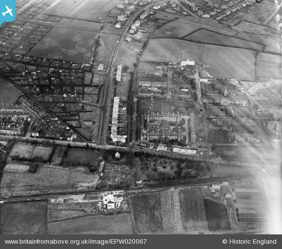
EPW020067 ENGLAND (1927). Public Assistance Institution (City General Hospital), Hartshill, 1927
© Copyright OpenStreetMap contributors and licensed by the OpenStreetMap Foundation. 2025. Cartography is licensed as CC BY-SA.
Details
| Title | [EPW020067] Public Assistance Institution (City General Hospital), Hartshill, 1927 |
| Reference | EPW020067 |
| Date | November-1927 |
| Link | |
| Place name | HARTSHILL |
| Parish | |
| District | |
| Country | ENGLAND |
| Easting / Northing | 385552, 345238 |
| Longitude / Latitude | -2.2153276925418, 53.003955484712 |
| National Grid Reference | SJ856452 |
Pins
 Tony W |
Tuesday 2nd of March 2021 10:38:14 AM | |
 Tony W |
Tuesday 2nd of March 2021 10:37:44 AM | |
 Tony W |
Tuesday 2nd of March 2021 10:37:34 AM | |
 Tony W |
Tuesday 2nd of March 2021 10:36:54 AM | |
 Tony W |
Tuesday 2nd of March 2021 10:36:36 AM | |
 Tony W |
Tuesday 2nd of March 2021 10:36:11 AM | |
 Tony W |
Tuesday 2nd of March 2021 10:35:54 AM |


![[EPW020067] Public Assistance Institution (City General Hospital), Hartshill, 1927](http://britainfromabove.org.uk/sites/all/libraries/aerofilms-images/public/100x100/EPW/020/EPW020067.jpg)
![[EPW041805] The City General Hospital, Stoke-on-Trent, 1933](http://britainfromabove.org.uk/sites/all/libraries/aerofilms-images/public/100x100/EPW/041/EPW041805.jpg)