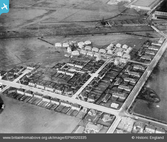
EPW020335 ENGLAND (1928). Noel Road and Moat Place, Acton, 1928
© Copyright OpenStreetMap contributors and licensed by the OpenStreetMap Foundation. 2024. Cartography is licensed as CC BY-SA.
Nearby Images (18)
Details
| Title | [EPW020335] Noel Road and Moat Place, Acton, 1928 |
| Reference | EPW020335 |
| Date | February-1928 |
| Link | |
| Place name | ACTON |
| Parish | |
| District | |
| Country | ENGLAND |
| Easting / Northing | 519819, 181497 |
| Longitude / Latitude | -0.27286855770067, 51.519186315575 |
| National Grid Reference | TQ198815 |
Pins
Be the first to add a comment to this image!


![[EPW020335] Noel Road and Moat Place, Acton, 1928](http://britainfromabove.org.uk/sites/all/libraries/aerofilms-images/public/100x100/EPW/020/EPW020335.jpg)
![[EPW020334] Norman Way, Acton, 1928](http://britainfromabove.org.uk/sites/all/libraries/aerofilms-images/public/100x100/EPW/020/EPW020334.jpg)
![[EPW020337] Walton Way, Acton, 1928](http://britainfromabove.org.uk/sites/all/libraries/aerofilms-images/public/100x100/EPW/020/EPW020337.jpg)
![[EPW020338] Norman Way, Acton, 1928](http://britainfromabove.org.uk/sites/all/libraries/aerofilms-images/public/100x100/EPW/020/EPW020338.jpg)
![[EPW020332] Walton Way and Public Playing Fields, Acton, 1928](http://britainfromabove.org.uk/sites/all/libraries/aerofilms-images/public/100x100/EPW/020/EPW020332.jpg)
![[EPW020336] Walton Way, Acton, 1928](http://britainfromabove.org.uk/sites/all/libraries/aerofilms-images/public/100x100/EPW/020/EPW020336.jpg)
![[EPW020857] Norman Way and environs, Acton, 1928](http://britainfromabove.org.uk/sites/all/libraries/aerofilms-images/public/100x100/EPW/020/EPW020857.jpg)
![[EPW020333] Norman Way and Public Playing Fields, Acton, 1928](http://britainfromabove.org.uk/sites/all/libraries/aerofilms-images/public/100x100/EPW/020/EPW020333.jpg)
![[EPW021148] Noel Road and Acton Housing Estate, Acton, 1928](http://britainfromabove.org.uk/sites/all/libraries/aerofilms-images/public/100x100/EPW/021/EPW021148.jpg)
![[EPW020331] Westfields Road and Public Playing Fields, Acton, 1928](http://britainfromabove.org.uk/sites/all/libraries/aerofilms-images/public/100x100/EPW/020/EPW020331.jpg)
![[EPW021151] Acton Housing Estate and Automobile Works, Acton, 1928](http://britainfromabove.org.uk/sites/all/libraries/aerofilms-images/public/100x100/EPW/021/EPW021151.jpg)
![[EPW020880] Housing development at Noel Road, Acton, 1928](http://britainfromabove.org.uk/sites/all/libraries/aerofilms-images/public/100x100/EPW/020/EPW020880.jpg)
![[EPW020881] Housing development at Noel Road, Acton, 1928](http://britainfromabove.org.uk/sites/all/libraries/aerofilms-images/public/100x100/EPW/020/EPW020881.jpg)
![[EPW020878] Housing development at Noel Road, Acton, 1928](http://britainfromabove.org.uk/sites/all/libraries/aerofilms-images/public/100x100/EPW/020/EPW020878.jpg)
![[EPW021154] Acton Housing Estate, Acton, from the south-east, 1928](http://britainfromabove.org.uk/sites/all/libraries/aerofilms-images/public/100x100/EPW/021/EPW021154.jpg)
![[EPW020882] Housing development at Noel Road and environs, Acton, 1928](http://britainfromabove.org.uk/sites/all/libraries/aerofilms-images/public/100x100/EPW/020/EPW020882.jpg)