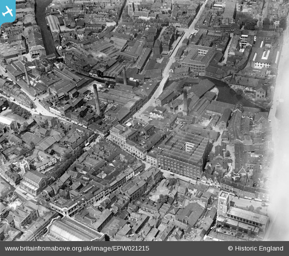
EPW021215 ENGLAND (1928). Duke's Palace Bridge and environs, Norwich, 1928
© Copyright OpenStreetMap contributors and licensed by the OpenStreetMap Foundation. 2025. Cartography is licensed as CC BY-SA.
Nearby Images (6)
Details
| Title | [EPW021215] Duke's Palace Bridge and environs, Norwich, 1928 |
| Reference | EPW021215 |
| Date | May-1928 |
| Link | |
| Place name | NORWICH |
| Parish | |
| District | |
| Country | ENGLAND |
| Easting / Northing | 622953, 308794 |
| Longitude / Latitude | 1.2949378574794, 52.630673454163 |
| National Grid Reference | TG230088 |
Pins
 Chris Lambert |
Sunday 26th of April 2015 03:59:55 PM | |
 Chris Lambert |
Sunday 26th of April 2015 03:58:58 PM | |
 Chris Lambert |
Sunday 5th of April 2015 03:57:00 PM | |
 Chris Lambert |
Sunday 5th of April 2015 03:55:40 PM | |
 Massingham |
Wednesday 12th of November 2014 09:08:49 PM | |
 Massingham |
Wednesday 12th of November 2014 09:02:53 PM | |
 Massingham |
Wednesday 12th of November 2014 08:59:48 PM | |
 Class31 |
Wednesday 5th of September 2012 10:20:10 PM | |
 Class31 |
Wednesday 5th of September 2012 10:17:44 PM | |
 Class31 |
Wednesday 5th of September 2012 10:17:05 PM | |
 Class31 |
Wednesday 5th of September 2012 10:15:32 PM |


![[EPW021215] Duke's Palace Bridge and environs, Norwich, 1928](http://britainfromabove.org.uk/sites/all/libraries/aerofilms-images/public/100x100/EPW/021/EPW021215.jpg)
![[EPW039747] Norwich Castle, Norwich Cathedral and the city centre, Norwich, 1932](http://britainfromabove.org.uk/sites/all/libraries/aerofilms-images/public/100x100/EPW/039/EPW039747.jpg)
![[EAW036846] The city centre, Norwich, 1951. This image has been produced from a print.](http://britainfromabove.org.uk/sites/all/libraries/aerofilms-images/public/100x100/EAW/036/EAW036846.jpg)
![[EAW036848] The city centre, Norwich, 1951. This image has been produced from a print.](http://britainfromabove.org.uk/sites/all/libraries/aerofilms-images/public/100x100/EAW/036/EAW036848.jpg)
![[EAW005080] City Hall, the Fire Station and environs, Norwich, 1947](http://britainfromabove.org.uk/sites/all/libraries/aerofilms-images/public/100x100/EAW/005/EAW005080.jpg)
![[EAW008141] Norwich Castle and environs, Norwich, 1947. This image was marked by Aerofilms Ltd for photo editing.](http://britainfromabove.org.uk/sites/all/libraries/aerofilms-images/public/100x100/EAW/008/EAW008141.jpg)