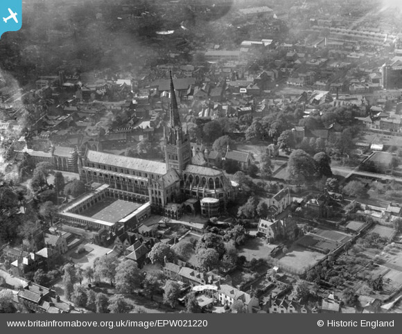
EPW021220 ENGLAND (1928). Norwich Cathedral, Norwich, 1928
© Copyright OpenStreetMap contributors and licensed by the OpenStreetMap Foundation. 2024. Cartography is licensed as CC BY-SA.
Nearby Images (32)
Details
| Title | [EPW021220] Norwich Cathedral, Norwich, 1928 |
| Reference | EPW021220 |
| Date | May-1928 |
| Link | |
| Place name | NORWICH |
| Parish | |
| District | |
| Country | ENGLAND |
| Easting / Northing | 623493, 308939 |
| Longitude / Latitude | 1.3030020112875, 52.631752912415 |
| National Grid Reference | TG235089 |
Pins
 Chris Lambert |
Sunday 12th of April 2015 04:28:50 PM | |
 Chris Lambert |
Sunday 12th of April 2015 04:27:20 PM | |
 Chris Lambert |
Sunday 12th of April 2015 04:25:07 PM | |
 Alan McFaden |
Friday 19th of July 2013 06:54:21 PM | |
 Alan McFaden |
Friday 19th of July 2013 06:53:41 PM |


![[EPW021220] Norwich Cathedral, Norwich, 1928](http://britainfromabove.org.uk/sites/all/libraries/aerofilms-images/public/100x100/EPW/021/EPW021220.jpg)
![[EAW001931] The Cathedral of the Holy and Undivided Trinity, Norwich, 1946](http://britainfromabove.org.uk/sites/all/libraries/aerofilms-images/public/100x100/EAW/001/EAW001931.jpg)
![[EPW006608] The Holy and Undivided Trinity Cathedral, Norwich, 1921](http://britainfromabove.org.uk/sites/all/libraries/aerofilms-images/public/100x100/EPW/006/EPW006608.jpg)
![[EAW005079] The Cathedral of the Holy and Undivided Trinity and environs, Norwich, 1947](http://britainfromabove.org.uk/sites/all/libraries/aerofilms-images/public/100x100/EAW/005/EAW005079.jpg)
![[EAW005078] The Cathedral of the Holy and Undivided Trinity, Norwich, 1947](http://britainfromabove.org.uk/sites/all/libraries/aerofilms-images/public/100x100/EAW/005/EAW005078.jpg)
![[EPW006607] The Holy and Undivided Trinity Cathedral, Norwich, 1921](http://britainfromabove.org.uk/sites/all/libraries/aerofilms-images/public/100x100/EPW/006/EPW006607.jpg)
![[EPW006606] The Holy and Undivided Trinity Cathedral and environs, Norwich, 1921](http://britainfromabove.org.uk/sites/all/libraries/aerofilms-images/public/100x100/EPW/006/EPW006606.jpg)
![[EAW008201] The Cathedral of the Holy and Undivided Trinity and environs, Norwich, 1947](http://britainfromabove.org.uk/sites/all/libraries/aerofilms-images/public/100x100/EAW/008/EAW008201.jpg)
![[EAW036852] The Cathedral of the Holy and Undivided Trinity, Norwich, 1951. This image has been produced from a print.](http://britainfromabove.org.uk/sites/all/libraries/aerofilms-images/public/100x100/EAW/036/EAW036852.jpg)
![[EPW021205] Holy Trinity Cathedral, Norwich, 1928](http://britainfromabove.org.uk/sites/all/libraries/aerofilms-images/public/100x100/EPW/021/EPW021205.jpg)
![[EAW001934] The Cathedral of the Holy and Undivided Trinity, Norwich, 1946](http://britainfromabove.org.uk/sites/all/libraries/aerofilms-images/public/100x100/EAW/001/EAW001934.jpg)
![[EPW021211] Holy Trinity Cathedral, Norwich, 1928](http://britainfromabove.org.uk/sites/all/libraries/aerofilms-images/public/100x100/EPW/021/EPW021211.jpg)
![[EAW002894] Norwich Cathedral and the city centre, Norwich, from the east, 1946](http://britainfromabove.org.uk/sites/all/libraries/aerofilms-images/public/100x100/EAW/002/EAW002894.jpg)
![[EAW036838] The Cathedral of the Holy and Undivided Trinity, Norwich, 1951. This image has been produced from a print marked by Aerofilms Ltd for photo editing.](http://britainfromabove.org.uk/sites/all/libraries/aerofilms-images/public/100x100/EAW/036/EAW036838.jpg)
![[EAW036855] The Cathedral of the Holy and Undivided Trinity, Norwich, 1951. This image has been produced from a print.](http://britainfromabove.org.uk/sites/all/libraries/aerofilms-images/public/100x100/EAW/036/EAW036855.jpg)
![[EAW036841] The Cathedral of the Holy and Undivided Trinity, Norwich, 1951. This image has been produced from a print marked by Aerofilms Ltd for photo editing.](http://britainfromabove.org.uk/sites/all/libraries/aerofilms-images/public/100x100/EAW/036/EAW036841.jpg)
![[EAW036854] The Cathedral of the Holy and Undivided Trinity, Norwich, 1951. This image has been produced from a print.](http://britainfromabove.org.uk/sites/all/libraries/aerofilms-images/public/100x100/EAW/036/EAW036854.jpg)
![[EAW002892] Norwich Cathedral, Norwich, 1946](http://britainfromabove.org.uk/sites/all/libraries/aerofilms-images/public/100x100/EAW/002/EAW002892.jpg)
![[EAW001933] The Cathedral of the Holy and Undivided Trinity, Norwich, 1946](http://britainfromabove.org.uk/sites/all/libraries/aerofilms-images/public/100x100/EAW/001/EAW001933.jpg)
![[EAW036840] The Cathedral of the Holy and Undivided Trinity, Norwich, 1951. This image has been produced from a print marked by Aerofilms Ltd for photo editing.](http://britainfromabove.org.uk/sites/all/libraries/aerofilms-images/public/100x100/EAW/036/EAW036840.jpg)
![[EAW036834] The Cathedral's Upper Close and environs, Norwich, 1951. This image has been produced from a print marked by Aerofilms Ltd for photo editing.](http://britainfromabove.org.uk/sites/all/libraries/aerofilms-images/public/100x100/EAW/036/EAW036834.jpg)
![[EAW036839] The Cathedral of the Holy and Undivided Trinity, Norwich, 1951. This image has been produced from a print marked by Aerofilms Ltd for photo editing.](http://britainfromabove.org.uk/sites/all/libraries/aerofilms-images/public/100x100/EAW/036/EAW036839.jpg)
![[EAW001932] The Cathedral of the Holy and Undivided Trinity, Norwich, 1946](http://britainfromabove.org.uk/sites/all/libraries/aerofilms-images/public/100x100/EAW/001/EAW001932.jpg)
![[EPW039748] Norwich Cathedral and Cloisters, Norwich, 1932](http://britainfromabove.org.uk/sites/all/libraries/aerofilms-images/public/100x100/EPW/039/EPW039748.jpg)
![[EAW036851] The Cathedral of the Holy and Undivided Trinity, Norwich, 1951. This image has been produced from a print.](http://britainfromabove.org.uk/sites/all/libraries/aerofilms-images/public/100x100/EAW/036/EAW036851.jpg)
![[EAW036850] The Cathedral of the Holy and Undivided Trinity, Norwich, 1951. This image has been produced from a print.](http://britainfromabove.org.uk/sites/all/libraries/aerofilms-images/public/100x100/EAW/036/EAW036850.jpg)
![[EAW036849] The Cathedral Close and environs, Norwich, 1951. This image has been produced from a print.](http://britainfromabove.org.uk/sites/all/libraries/aerofilms-images/public/100x100/EAW/036/EAW036849.jpg)
![[EPW021218] Holy Trinity Cathedral, Norwich, 1928](http://britainfromabove.org.uk/sites/all/libraries/aerofilms-images/public/100x100/EPW/021/EPW021218.jpg)
![[EAW036837] The Cathedral Close and environs, Norwich, 1951. This image has been produced from a print marked by Aerofilms Ltd for photo editing.](http://britainfromabove.org.uk/sites/all/libraries/aerofilms-images/public/100x100/EAW/036/EAW036837.jpg)
![[EPW039222] The British Gas Light Co. Works at St Martin at Palace Plain and environs, Norwich, 1932](http://britainfromabove.org.uk/sites/all/libraries/aerofilms-images/public/100x100/EPW/039/EPW039222.jpg)
![[EAW001952] Bally and Haldinstein Ltd Boot and Shoe Manufactory and environs, Norwich, 1946](http://britainfromabove.org.uk/sites/all/libraries/aerofilms-images/public/100x100/EAW/001/EAW001952.jpg)
![[EAW001950] Bally and Haldinstein Ltd Boot and Shoe Manufactory, Norwich, 1946](http://britainfromabove.org.uk/sites/all/libraries/aerofilms-images/public/100x100/EAW/001/EAW001950.jpg)

