
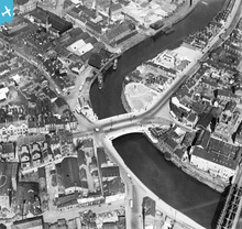
EPW021589 ENGLAND (1928). Warrington Bridge, Warrington, 1928

© Copyright OpenStreetMap contributors and licensed by the OpenStreetMap Foundation. 2025. Cartography is licensed as CC BY-SA.
Nearby Images (9)
EPW021589

EPW005004

EPW005010

EPW034303

EPW034308

EPW034305

EPW034306

EPW034309

EPW034311

Details
| Title | [EPW021589] Warrington Bridge, Warrington, 1928 |
| Reference | EPW021589 |
| Date | June-1928 |
| Link | |
| Place name | WARRINGTON |
| Parish | |
| District | |
| Country | ENGLAND |
| Easting / Northing | 360778, 387827 |
| Longitude / Latitude | -2.5897668792653, 53.385565583165 |
| National Grid Reference | SJ608878 |
Pins
 Bottom Yard |
Friday 15th of November 2024 02:55:29 PM | |
robert |
Tuesday 21st of May 2024 05:36:34 PM | |
Bottom Yard |
Wednesday 7th of June 2023 12:39:48 PM | |
Bottom Yard |
Wednesday 7th of June 2023 12:18:02 PM | |
Bottom Yard |
Wednesday 7th of June 2023 12:14:43 PM | |
SAB |
Saturday 2nd of April 2022 11:09:33 AM | |
NeilRobertson |
Sunday 19th of September 2021 08:24:10 AM | |
 Ginger79 |
Monday 8th of March 2021 09:36:44 PM | |
gareth |
Saturday 26th of October 2019 03:29:17 PM | |
yossel |
Thursday 9th of August 2012 02:24:00 PM |
User Comment Contributions
Bishops Wharf just beyond bridge |
boatmanckp |
Friday 20th of July 2012 12:47:36 PM |
 Boats used the river Mersey here. |
Frank S |
Saturday 30th of June 2012 11:19:36 AM |